
$1,750
/ Month
2335 Seventh St Unit B
Berkeley, CA 94710
Favorites
2335 Seventh St Unit B

Favorites
Check Back Soon for Upcoming Availability
| Beds | Baths | Average SF |
|---|---|---|
| 1 Bedroom 1 Bedroom 1 Br | 1 Bath 1 Bath 1 Ba | — |
About This Property
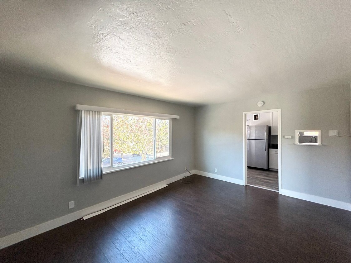
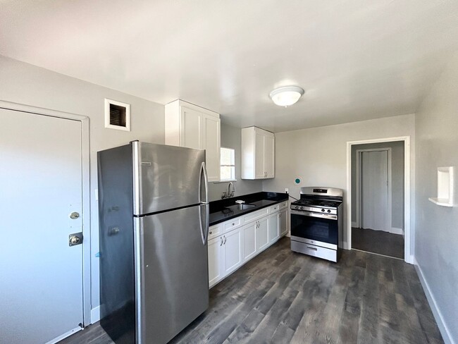
If you're moving to Berkeley, CA, this great property could be your new rental. Located at 2335 Seventh St in Berkeley, this apartment unit for rent is convenient to nearby destinations. With this great space, you'll feel right at home. Reach out to see everything this home offers.
2335 Seventh St is an apartment community located in Alameda County and the 94710 ZIP Code.
2335 Seventh St,
Berkeley,
CA
94710
Southwest Berkeley is bounded by University Avenue to the north, Sacramento Street to the East, Alcatraz Avenue to the south and the San Francisco Bay to the west. Southwest Berkeley comprises a fascinating mix of the educational and the industrial. Less dense than the more inland parts of Berkeley, Southwest Berkeley has a diverse mix of apartment and home rentals that will delight students and families alike. Convenient access to the illustrious university make this a great option for students and staff, but any renter will love the restaurant and retail options that make this walkable locale so convenient.
Learn more about living in Southwest BerkeleyBelow are rent ranges for similar nearby apartments
| Beds | Average Size | Lowest | Typical | Premium |
|---|---|---|---|---|
| Studio Studio Studio | 373-375 Sq Ft | $1,795 | $2,392 | $4,090 |
| 1 Bed 1 Bed 1 Bed | 692 Sq Ft | $1,450 | $2,626 | $3,640 |
| 2 Beds 2 Beds 2 Beds | 989-991 Sq Ft | $2,050 | $3,628 | $6,359 |
| 3 Beds 3 Beds 3 Beds | 1330 Sq Ft | $3,975 | $4,507 | $5,000 |
| 4 Beds 4 Beds 4 Beds | 1824 Sq Ft | $6,414 | $6,936 | $8,500 |
Education
| Colleges & Universities | Distance | ||
|---|---|---|---|
| Colleges & Universities | Distance | ||
| Drive: | 5 min | 1.8 mi | |
| Drive: | 10 min | 3.1 mi | |
| Drive: | 12 min | 4.7 mi | |
| Drive: | 10 min | 5.9 mi |
2335 Seventh St Unit B is within 5 minutes or 1.8 miles from Berkeley City College. It is also near UC Berkeley and Samuel Merritt University.
Transportation options available in Berkeley include North Berkeley, located 1.4 miles from 2335 Seventh St Unit B. 2335 Seventh St Unit B is near Metro Oakland International, located 16.3 miles or 24 minutes away, and San Francisco International, located 23.9 miles or 37 minutes away.
| Transit / Subway | Distance | ||
|---|---|---|---|
| Transit / Subway | Distance | ||
|
|
Drive: | 4 min | 1.4 mi |
|
|
Drive: | 6 min | 1.9 mi |
|
|
Drive: | 6 min | 2.1 mi |
|
|
Drive: | 12 min | 3.8 mi |
|
|
Drive: | 12 min | 4.9 mi |
| Commuter Rail | Distance | ||
|---|---|---|---|
| Commuter Rail | Distance | ||
|
|
Drive: | 3 min | 1.2 mi |
| Drive: | 5 min | 1.8 mi | |
| Drive: | 12 min | 7.1 mi | |
|
|
Drive: | 13 min | 7.8 mi |
| Drive: | 18 min | 11.5 mi |
| Airports | Distance | ||
|---|---|---|---|
| Airports | Distance | ||
|
Metro Oakland International
|
Drive: | 24 min | 16.3 mi |
|
San Francisco International
|
Drive: | 37 min | 23.9 mi |
Walkability Near 2335 Seventh St Berkeley, CA 94710
Getting Around
 What do Walkability, Transit, Drivability, and Bikeability mean?
Walkability measures the walking distance to day-to-day needs.
Transit measures access to public transportation.
Drivability measures congestion, parking availability, and access to major roads.
Bikeability measures the suitability for cycling.
How It Works
What do Walkability, Transit, Drivability, and Bikeability mean?
Walkability measures the walking distance to day-to-day needs.
Transit measures access to public transportation.
Drivability measures congestion, parking availability, and access to major roads.
Bikeability measures the suitability for cycling.
How It Works
Moderately Walkable
Walkability
70
/ 100
Good Public Transit
Transit
60
/ 100
Very Drivable
Drivability
80
/ 100
Very Bikeable
Bikeability
80
/ 100
Scores provided by
-
Soundscore™
-
/ 100
Traffic
-Airport
-Businesses
-Scores provided by
HowLoud What is a Sound Score Rating? A Sound Score Rating aggregates noise caused by vehicle traffic, airplane traffic and local sources. How It WorksTime and distance from 2335 Seventh St Unit B.
| Shopping Centers | Distance | ||
|---|---|---|---|
| Shopping Centers | Distance | ||
| Walk: | 9 min | 0.5 mi | |
| Walk: | 11 min | 0.6 mi | |
| Drive: | 4 min | 1.4 mi |
2335 Seventh St Unit B has 3 shopping centers within 1.4 miles, which is about a 4-minute drive. The miles and minutes will be for the farthest away property.
| Parks and Recreation | Distance | ||
|---|---|---|---|
| Parks and Recreation | Distance | ||
|
Strawberry Creek Park
|
Walk: | 13 min | 0.7 mi |
|
McLaughlin Eastshore State Park
|
Walk: | 23 min | 1.2 mi |
|
Shorebird Nature Center
|
Drive: | 4 min | 1.5 mi |
|
Cedar-Rose Park
|
Drive: | 4 min | 1.5 mi |
|
San Francisco Bay Trail (at Emeryville)
|
Drive: | 4 min | 1.6 mi |
2335 Seventh St Unit B has 5 parks within 1.6 miles, including Strawberry Creek Park, McLaughlin Eastshore State Park, and Cedar-Rose Park.
| Hospitals | Distance | ||
|---|---|---|---|
| Hospitals | Distance | ||
| Drive: | 8 min | 2.7 mi | |
| Drive: | 8 min | 2.9 mi | |
| Drive: | 9 min | 5.8 mi |
2335 Seventh St Unit B has 3 hospitals within 5.8 miles, the nearest is Alta Bates Summit Medical Center - Alta Bates Campus which is 2.7 miles away and a 8 minute drive.
| Military Bases | Distance | ||
|---|---|---|---|
| Military Bases | Distance | ||
| Drive: | 13 min | 6.1 mi | |
| Drive: | 15 min | 6.9 mi | |
| Drive: | 18 min | 9.9 mi |
2335 Seventh St Unit B has 3 military bases within 9.9 miles, the nearest is Military Reservation which is 6.1 miles away and a 13 minute drive.
You May Also Like
Similar Rentals Nearby
-
-
1 Bed$3,042+2 Beds$5,130Total Monthly Price12 Month LeaseTotal Monthly Price NewPrices include base rent and required monthly fees. Variable costs based on usage may apply.Specials
Pets Allowed Fitness Center In Unit Washer & Dryer Stainless Steel Appliances Business Center Package Service Elevator
-
1 Bed$2,785+Total Monthly PriceTotal Monthly Price NewPrices include base rent and required monthly fees of $5. Variable costs based on usage may apply.Base Rent:1 Bed$2,779+2 Months Free
Pets Allowed Fitness Center In Unit Washer & Dryer Walk-In Closets Stainless Steel Appliances Hardwood Floors EV Charging
-
-
-
-
-
-
-


What Are Walk Score®, Transit Score®, and Bike Score® Ratings?
Walk Score® measures the walkability of any address. Transit Score® measures access to public transit. Bike Score® measures the bikeability of any address.
What is a Sound Score Rating?
A Sound Score Rating aggregates noise caused by vehicle traffic, airplane traffic and local sources.

2335 Seventh St
Berkeley, CA 94710