
-
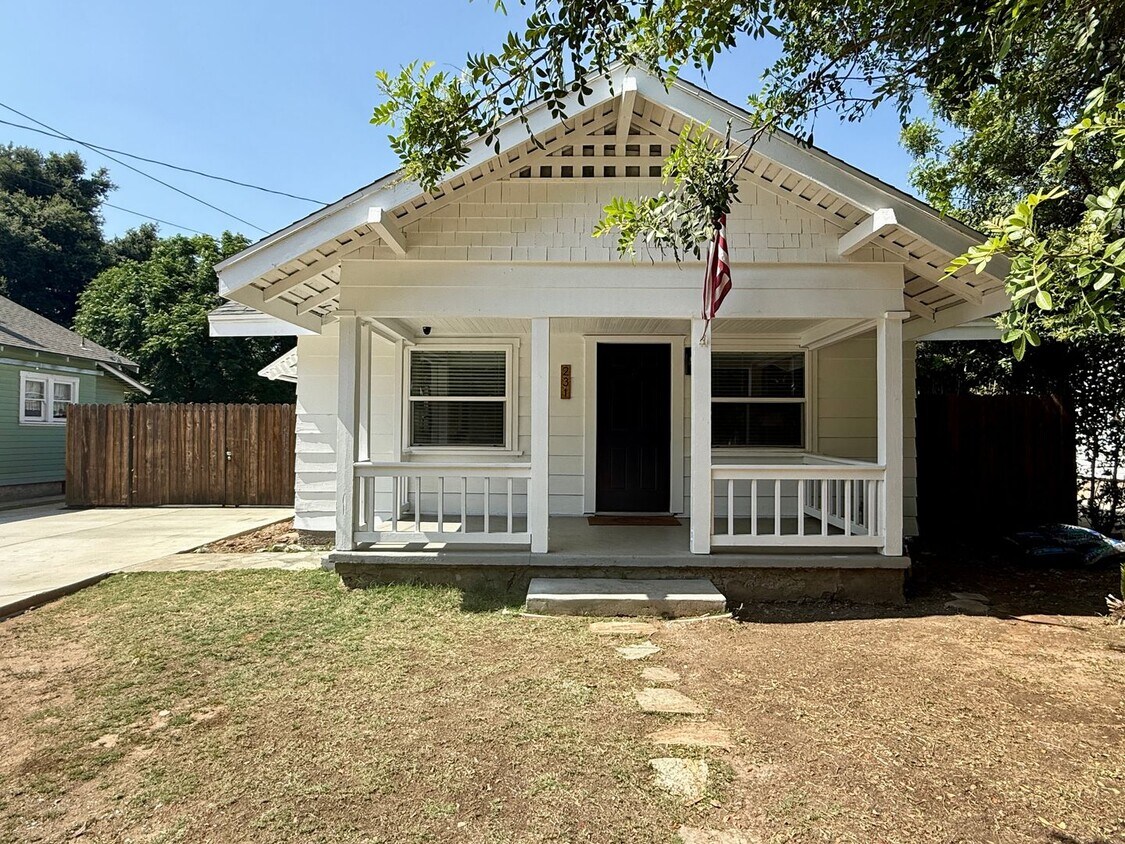
Charming 2 bedroom 1 Bathroom

$3,250 / Month
231 W Railway St
San Dimas, CA 91773
Today
Favorites
714-519-5795
-
Bedrooms
2
-
Bathrooms
1
-
Square Feet
800 sq ft
-
Available
Available Now
231 W Railway St

Favorites
About This Home
Available Now
2 bedroom, 1 bath in San Dimas
231 W Railway St is a house located in Los Angeles County and the 91773 ZIP Code. This area is served by the Bonita Unified attendance zone.
* Price shown is base rent and may not include non-optional fees and utilities.
Price, availability, fees, and any applicable rent special are subject to change without notice.
* Square footage definitions vary. Displayed square footage is approximate.
Contact
- Listed by Progressive Property Management, Inc. | Progressive Property Management, Inc.
- Phone Number
- Contact
Location
Get Directions
Just a little over 30 miles east from Downtown Los Angeles, the Bonita neighborhood encompasses the whole northern part of the city of San Dimas and parts of La Verne. The Bonita neighborhood sits at the base of the San Gabriel Mountains, giving residents a beautiful mountain backdrop to enjoy. Being so close to both the mountains and just a quick drive away from Downtown LA, this neighborhood has seen a steady growth through the years. This popular suburb attracts many families due to the Bonita Unified School District which includes 14 schools and serves over 10,000 students. A number of classically LA apartments and a few single-family homes means there’s something for everyone in Bonita.
Learn more about living in Bonita
Education
| Colleges & Universities | Distance | ||
|---|---|---|---|
| Colleges & Universities | Distance | ||
| Drive: | 4 min | 2.7 mi | |
| Drive: | 10 min | 5.6 mi | |
| Drive: | 11 min | 6.6 mi | |
| Drive: | 11 min | 7.4 mi |
231 W Railway St is within 4 minutes or 2.7 miles from University of La Verne. It is also near DeVry University-California and Cal Poly Pomona.
Schools


Public Elementary School
Grades K-5
493 Students
Attendance Zone
Public Elementary & Middle School
Grades K-8
608 Students
Nearby
Public Middle School
Grades 6-8
912 Students
Attendance Zone
Public High School
Grades 9-12
1,251 Students
Attendance Zone
Private Elementary & Middle School
Grades PK-7
70 Students
Nearby
Private Elementary School
Grades PK-3
96 Students
Nearby
Private High School
Grades 9-12
836 Students
Nearby
School data provided by
 The GreatSchools Rating helps parents compare schools within a state based on a variety of school quality indicators and provides a helpful picture of how effectively each school serves all of its students. Ratings are on a scale of 1 (below average) to 10 (above average) and can include test scores, college readiness, academic progress, advanced courses, equity, discipline and attendance data. We also advise parents to visit schools, consider other information on school performance and programs, and consider family needs as part of the school selection process.
View GreatSchools Rating Methodology
Data provided by GreatSchools.org © 2025. All rights reserved.
View GreatSchools Rating Methodology
Data provided by GreatSchools.org © 2025. All rights reserved.
Transportation options available in San Dimas include Apu / Citrus College Station, located 7.1 miles from 231 W Railway St. 231 W Railway St is near Ontario International, located 14.3 miles or 21 minutes away, and Long Beach (Daugherty Field), located 36.0 miles or 48 minutes away.
| Transit / Subway | Distance | ||
|---|---|---|---|
| Transit / Subway | Distance | ||
| Drive: | 11 min | 7.1 mi | |
| Drive: | 10 min | 7.6 mi | |
| Drive: | 12 min | 8.9 mi | |
| Drive: | 14 min | 11.3 mi |
| Commuter Rail | Distance | ||
|---|---|---|---|
| Commuter Rail | Distance | ||
| Drive: | 8 min | 4.3 mi | |
| Drive: | 9 min | 5.7 mi | |
| Drive: | 10 min | 6.0 mi | |
| Drive: | 10 min | 6.2 mi | |
| Drive: | 12 min | 7.2 mi |
| Airports | Distance | ||
|---|---|---|---|
| Airports | Distance | ||
|
Ontario International
|
Drive: | 21 min | 14.3 mi |
|
Long Beach (Daugherty Field)
|
Drive: | 48 min | 36.0 mi |
Time and distance from 231 W Railway St.
| Shopping Centers | Distance | ||
|---|---|---|---|
| Shopping Centers | Distance | ||
| Walk: | 6 min | 0.3 mi | |
| Walk: | 7 min | 0.4 mi | |
| Walk: | 8 min | 0.4 mi |
231 W Railway St has 3 shopping centers within 0.4 mile, which is about a 8-minute walk. The miles and minutes will be for the farthest away property.
| Parks and Recreation | Distance | ||
|---|---|---|---|
| Parks and Recreation | Distance | ||
|
San Dimas Canyon Nature Center
|
Drive: | 5 min | 2.7 mi |
|
Frank G. Bonelli Regional Park
|
Drive: | 8 min | 4.3 mi |
|
Covina Park
|
Drive: | 9 min | 5.6 mi |
|
Alf Museum of Paleontology
|
Drive: | 10 min | 5.8 mi |
|
Rancho Santa Ana Botanic Garden
|
Drive: | 11 min | 6.6 mi |
231 W Railway St has 5 parks within 6.6 miles, including San Dimas Canyon Nature Center, Frank G. Bonelli Regional Park, and Alf Museum of Paleontology.
| Hospitals | Distance | ||
|---|---|---|---|
| Hospitals | Distance | ||
| Drive: | 2 min | 1.8 mi | |
| Drive: | 6 min | 3.7 mi | |
| Drive: | 7 min | 3.9 mi |
231 W Railway St has 3 hospitals within 3.9 miles, the nearest is San Dimas Community Hospital which is 1.8 miles away and a 2 minute drive.
| Military Bases | Distance | ||
|---|---|---|---|
| Military Bases | Distance | ||
| Drive: | 45 min | 34.2 mi |
231 W Railway St is 34.2 miles and a 45 minute drive from Los Alamitos Army Airfield.
You May Also Like
Similar Rentals Nearby


What Are Walk Score®, Transit Score®, and Bike Score® Ratings?
Walk Score® measures the walkability of any address. Transit Score® measures access to public transit. Bike Score® measures the bikeability of any address.
What is a Sound Score Rating?
A Sound Score Rating aggregates noise caused by vehicle traffic, airplane traffic and local sources
231 W Railway St
San Dimas, CA 91773