
$3,800 / Month
2308 Defoors Ferry Rd NW
Atlanta, GA 30318
2 Weeks Ago
Favorites
2308 Defoors Ferry Rd NW

Favorites
Check Back Soon for Upcoming Availability
| Beds | Baths | Average SF |
|---|---|---|
| 4 Bedrooms 4 Bedrooms 4 Br | 3.5 Baths 3.5 Baths 3.5 Ba | — |
Fees and Policies
The fees below are based on community-supplied data and may exclude additional fees and utilities.
- Parking
-
Garage--
About This Property
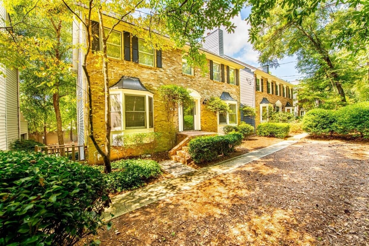
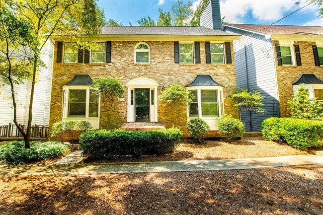
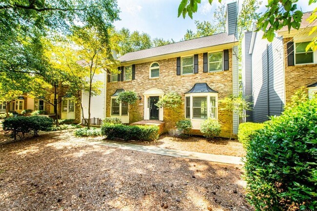
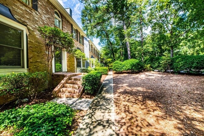
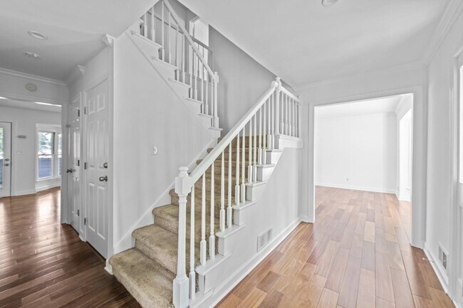
Amazing Location. Close to all the restaurants & shops at Westside Provisions District and Atlantic Station. This home features natural hardwoods throughout the main level, updated kitchen and bathrooms. Fresh paint throughout the house. Master bedroom features a fireplace and custom closet design. Frameless shower and soaking tub in huge master suite bathroom. Large screen porch to entertain. Newly roof. Fully finished lower level with a full bath. This home is a must-see!
2308 Defoors Ferry Rd NW is a house located in Fulton County and the 30318 ZIP Code. This area is served by the Atlanta Public Schools attendance zone.
House Features
Dishwasher
Microwave
Refrigerator
Double Vanities
- Double Vanities
- Dishwasher
- Microwave
- Refrigerator
Location
Get Directions
The Upper West Side (or the Upper Westside) refers to the northwestern portion of Atlanta situated between I-75 and I-285. The Upper West Side is brimming with an array of historic neighborhoods, including larger communities like Riverside, Bolton, and Whittier Mill Village. The region is also convenient to neighboring Vinings and Buckhead, which are both teeming with various area employers.
The Upper West Side is a region on the rise, with plenty of new development in the works in addition to community mainstays such as B’s Cracklin’ Barbeque and assorted breweries like Scofflaw Brewing Company, Atlanta Brewing Company, and Second Self Beer Company.
The community is also home to Whittier Mill Park, the former site of Whittier Cotton Mill offering historic ruins and scenic trails to explore alongside the Chattahoochee River. The Upper West Side’s convenient locale, growing amenities, and overall peaceful atmosphere makes it a top choice for renters in the Atlanta area.
Learn more about living in Upper West SideBelow are rent ranges for similar nearby apartments
| Beds | Average Size | Lowest | Typical | Premium |
|---|---|---|---|---|
| Studio Studio Studio | 563-564 Sq Ft | $1,075 | $2,063 | $10,000 |
| 1 Bed 1 Bed 1 Bed | 776 Sq Ft | $930 | $2,326 | $10,000 |
| 2 Beds 2 Beds 2 Beds | 1146-1147 Sq Ft | $924 | $2,752 | $11,040 |
| 3 Beds 3 Beds 3 Beds | 1466 Sq Ft | $925 | $2,835 | $8,129 |
| 4 Beds 4 Beds 4 Beds | 1585-1586 Sq Ft | $684 | $1,787 | $19,999 |
Amenities
- Double Vanities
- Dishwasher
- Microwave
- Refrigerator
Education
| Colleges & Universities | Distance | ||
|---|---|---|---|
| Colleges & Universities | Distance | ||
| Drive: | 11 min | 4.4 mi | |
| Drive: | 13 min | 6.1 mi | |
| Drive: | 13 min | 6.1 mi | |
| Drive: | 13 min | 6.5 mi |
2308 Defoors Ferry Rd NW is within 11 minutes or 4.4 miles from Georgia Tech. It is also near Clark Atlanta University and Georgia State University.
Schools


Public Elementary School
Grades PK-5
553 Students
Nearby
Public Elementary School
Grades PK-5
865 Students
Attendance Zone
Public Middle School
Grades 6-8
1,548 Students
Attendance Zone
Public High School
Grades 9-12
2,316 Students
Attendance Zone
Private Elementary School
Grades PK-6
345 Students
Nearby
Private Middle & High School
Grades 6-12
215 Students
Nearby
School data provided by
 The GreatSchools Rating helps parents compare schools within a state based on a variety of school quality indicators and provides a helpful picture of how effectively each school serves all of its students. Ratings are on a scale of 1 (below average) to 10 (above average) and can include test scores, college readiness, academic progress, advanced courses, equity, discipline and attendance data. We also advise parents to visit schools, consider other information on school performance and programs, and consider family needs as part of the school selection process.
View GreatSchools Rating Methodology
Data provided by GreatSchools.org © 2025. All rights reserved.
View GreatSchools Rating Methodology
Data provided by GreatSchools.org © 2025. All rights reserved.
Transportation options available in Atlanta include Bankhead, located 4.2 miles from 2308 Defoors Ferry Rd NW. 2308 Defoors Ferry Rd NW is near Hartsfield - Jackson Atlanta International, located 16.0 miles or 27 minutes away.
| Transit / Subway | Distance | ||
|---|---|---|---|
| Transit / Subway | Distance | ||
|
|
Drive: | 9 min | 4.2 mi |
|
|
Drive: | 10 min | 4.6 mi |
|
|
Drive: | 11 min | 4.9 mi |
|
|
Drive: | 11 min | 5.2 mi |
|
|
Drive: | 11 min | 5.3 mi |
| Commuter Rail | Distance | ||
|---|---|---|---|
| Commuter Rail | Distance | ||
|
|
Drive: | 8 min | 3.4 mi |
| Airports | Distance | ||
|---|---|---|---|
| Airports | Distance | ||
|
Hartsfield - Jackson Atlanta International
|
Drive: | 27 min | 16.0 mi |
Time and distance from 2308 Defoors Ferry Rd NW.
| Shopping Centers | Distance | ||
|---|---|---|---|
| Shopping Centers | Distance | ||
| Walk: | 14 min | 0.7 mi | |
| Walk: | 18 min | 0.9 mi | |
| Drive: | 4 min | 1.5 mi |
2308 Defoors Ferry Rd NW has 3 shopping centers within 1.5 miles, which is about a 4-minute walk. The miles and minutes will be for the farthest away property.
| Parks and Recreation | Distance | ||
|---|---|---|---|
| Parks and Recreation | Distance | ||
|
Piedmont Park
|
Drive: | 11 min | 5.1 mi |
|
Georgia Conservancy
|
Drive: | 12 min | 5.3 mi |
|
Atlanta Botanical Garden
|
Drive: | 12 min | 5.4 mi |
|
Atlanta History Center
|
Drive: | 12 min | 5.9 mi |
|
Chastain Park
|
Drive: | 20 min | 7.4 mi |
2308 Defoors Ferry Rd NW has 5 parks within 7.4 miles, including Atlanta History Center, Georgia Conservancy, and Piedmont Park.
| Hospitals | Distance | ||
|---|---|---|---|
| Hospitals | Distance | ||
| Drive: | 7 min | 2.9 mi | |
| Drive: | 11 min | 5.4 mi | |
| Drive: | 13 min | 6.6 mi |
2308 Defoors Ferry Rd NW has 3 hospitals within 6.6 miles, the nearest is Piedmont Hospital which is 2.9 miles away and a 7 minute drive.
| Military Bases | Distance | ||
|---|---|---|---|
| Military Bases | Distance | ||
| Drive: | 20 min | 9.4 mi | |
| Drive: | 23 min | 10.7 mi |
2308 Defoors Ferry Rd NW is 9.4 miles from Fort McPherson, and is convenient to other military bases, including Dobbins Air Force Base.
You May Also Like
Similar Rentals Nearby


What Are Walk Score®, Transit Score®, and Bike Score® Ratings?
Walk Score® measures the walkability of any address. Transit Score® measures access to public transit. Bike Score® measures the bikeability of any address.
What is a Sound Score Rating?
A Sound Score Rating aggregates noise caused by vehicle traffic, airplane traffic and local sources

2308 Defoors Ferry Rd NW
Atlanta, GA 30318