
The Equestrian At Pelham Parkway
1680 Pelham Pkwy S,
Bronx, NY 10461
$1,850 - $2,900
Studio - 2 Beds
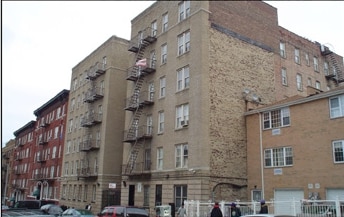
2300 Loring Pl N is ready to be your home. This community is located on Loring Pl N. in Bronx. The professional leasing team is ready to help match you with your perfect new apartment. 2300 Loring Pl N offers a variety of available amenities and features including: smoke free options, convenient on-site parking options, and high-speed internet access. At 2300 Loring Pl N you'll feel right at home. Stop by the community today.
2300 Loring Pl N is an apartment community located in Bronx County and the 10468 ZIP Code. This area is served by the New York City Geographic District #10 attendance zone.
High Speed Internet Access
Refrigerator
Smoke Free
Oven
University Heights is a historic neighborhood in the Bronx. As its name implies, University Heights was once home to New York University. Today, Bronx Community College is located in NYU’s old buildings, and many of them have earned a National Historic Landmark designation. The Hall of Fame for Great Americans is also located in University Heights. Like many New York neighborhoods, University Heights has multiple bus stops, several subway stations, and apartments and condos available for rent. Parks and greenways are located throughout University Heights, adding a pop of greenery in this urban neighborhood. University Woods overlooks the Harlem River while Roberto Clemente State Park is a popular spot for swimming.
Learn more about living in University HeightsCompare neighborhood and city base rent averages by bedroom.
| University Heights | Bronx, NY | |
|---|---|---|
| Studio | $1,275 | $1,630 |
| 1 Bedroom | $1,650 | $1,634 |
| 2 Bedrooms | $1,871 | $2,101 |
| 3 Bedrooms | $2,108 | $2,370 |
| Colleges & Universities | Distance | ||
|---|---|---|---|
| Colleges & Universities | Distance | ||
| Walk: | 10 min | 0.5 mi | |
| Walk: | 10 min | 0.6 mi | |
| Drive: | 5 min | 1.4 mi | |
| Drive: | 4 min | 1.4 mi |


Transportation options available in Bronx include Fordham Road (4 Line), located 0.4 mile from 2300 Loring Pl N. 2300 Loring Pl N is near LaGuardia, located 10.5 miles or 19 minutes away, and John F Kennedy International, located 21.2 miles or 32 minutes away.
| Transit / Subway | Distance | ||
|---|---|---|---|
| Transit / Subway | Distance | ||
|
|
Walk: | 8 min | 0.4 mi |
|
|
Walk: | 11 min | 0.6 mi |
|
|
Walk: | 13 min | 0.7 mi |
|
|
Walk: | 17 min | 0.9 mi |
|
|
Drive: | 3 min | 1.2 mi |
| Commuter Rail | Distance | ||
|---|---|---|---|
| Commuter Rail | Distance | ||
|
|
Walk: | 10 min | 0.5 mi |
|
|
Walk: | 19 min | 1.0 mi |
|
|
Drive: | 4 min | 1.4 mi |
|
|
Drive: | 5 min | 1.8 mi |
|
|
Drive: | 5 min | 1.8 mi |
| Airports | Distance | ||
|---|---|---|---|
| Airports | Distance | ||
|
LaGuardia
|
Drive: | 19 min | 10.5 mi |
|
John F Kennedy International
|
Drive: | 32 min | 21.2 mi |
Scores provided by
Traffic
-Airport
-Businesses
-Scores provided by
HowLoud What is a Sound Score Rating? A Sound Score Rating aggregates noise caused by vehicle traffic, airplane traffic and local sources. How It WorksTime and distance from 2300 Loring Pl N.
| Shopping Centers | Distance | ||
|---|---|---|---|
| Shopping Centers | Distance | ||
| Walk: | 14 min | 0.8 mi | |
| Walk: | 17 min | 0.9 mi | |
| Drive: | 3 min | 1.2 mi |
| Parks and Recreation | Distance | ||
|---|---|---|---|
| Parks and Recreation | Distance | ||
|
St. James Park
|
Walk: | 14 min | 0.7 mi |
|
Poe Park
|
Walk: | 16 min | 0.9 mi |
|
Dyckman House Park
|
Drive: | 3 min | 1.1 mi |
|
Roberto Clemente State Park
|
Drive: | 5 min | 1.5 mi |
|
Sherman Creek and Swindler Cove
|
Drive: | 11 min | 5.0 mi |
| Hospitals | Distance | ||
|---|---|---|---|
| Hospitals | Distance | ||
| Drive: | 5 min | 1.5 mi | |
| Drive: | 6 min | 2.6 mi | |
| Drive: | 9 min | 3.3 mi |
| Military Bases | Distance | ||
|---|---|---|---|
| Military Bases | Distance | ||
| Drive: | 22 min | 11.6 mi |
What Are Walk Score®, Transit Score®, and Bike Score® Ratings?
Walk Score® measures the walkability of any address. Transit Score® measures access to public transit. Bike Score® measures the bikeability of any address.
What is a Sound Score Rating?
A Sound Score Rating aggregates noise caused by vehicle traffic, airplane traffic and local sources.


