
$4,000 / Month
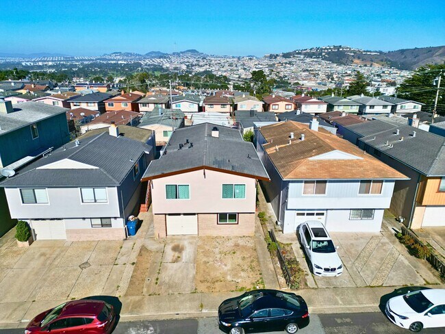
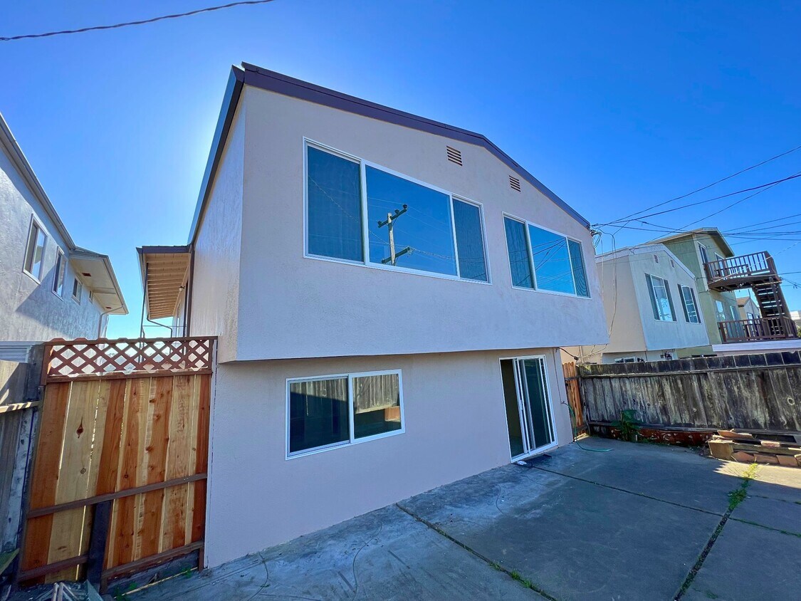
228 San Fernando Way
Daly City, CA 94015
2 Weeks Ago
Favorites
228 San Fernando Way

Favorites
Check Back Soon for Upcoming Availability
| Beds | Baths | Average SF |
|---|---|---|
| 4 Bedrooms 4 Bedrooms 4 Br | 2.5 Baths 2.5 Baths 2.5 Ba | — |
About This Property
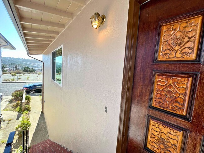
Expansive 4-bed, 2.5-bath Home with Large Bonus Room This spacious home features brand-new carpet, freshly painted bathrooms, and new windows throughout, creating a quiet and cozy environment. Enjoy commanding views of the Golden Gate Bridge from the living room and watch the city lights as the sun sets. The entire private home is available for rent. The downstairs area includes a bedroom, a bathroom, and a large bonus room that can be used as a home office, playroom, or workout studio. The possibilities are endless with this single-family home. It won't last long—book your tour today! Centrally located, the property is close to Highway 280 and HWY 35, and just minutes from San Francisco. It's within walking distance of Serramonte Mall, Target, and the DC Farmers Market. Additional features include a formal dining room, a living room with a fireplace, and space for 3 off-street parking spots. OPEN HOUSE: Saturday, November 2, 2024, from 12:00 Noon to 2:00 Pm
228 San Fernando Way is a house located in San Mateo County and the 94015 ZIP Code. This area is served by the Jefferson Elementary attendance zone.
Location
Get Directions
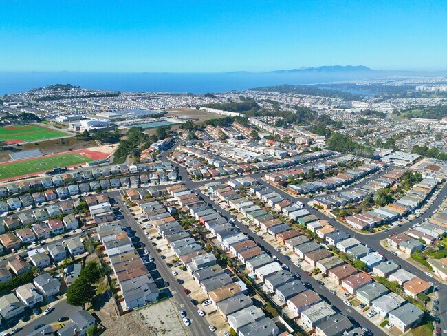
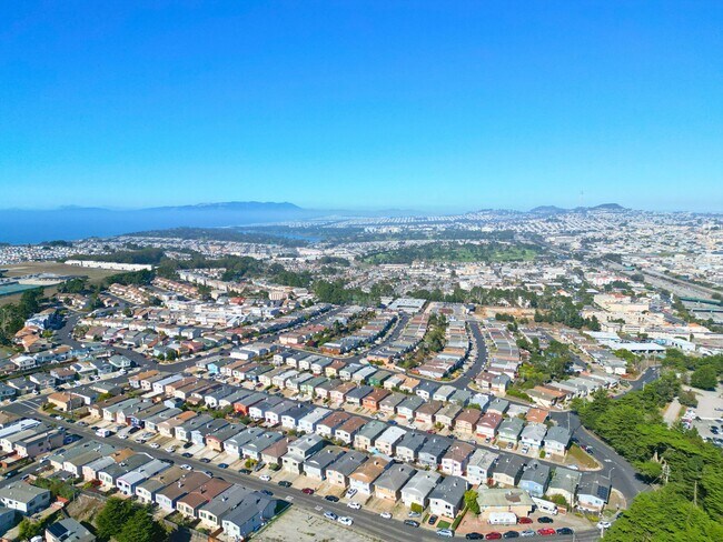
Saint Francis is a suburban neighborhood known for its large single-family houses, but there is a variety of mid-rise and luxury apartments available for rent as well. Since Saint Frances is about 10 miles south of San Francisco, the neighborhood is a popular area for commuters. Residents have access to Highway 35 and 1 and Interstate 280 so traveling into the city is easy. The neighborhood is family friendly with excellent schools and access to plenty of green space and amenities. Along with its own stores and restaurants, Saint Frances is about two miles away from several large shopping centers like Serra Center and Serramonte Center, a large mall. Golf courses like Lake Merced Golf Club are just a short drive away while waterfront parks like Mussel Rock Park offer picturesque views of the Pacific Ocean, low-key beaches, and hiking trails.
Learn more about living in St FrancisBelow are rent ranges for similar nearby apartments
Education
| Colleges & Universities | Distance | ||
|---|---|---|---|
| Colleges & Universities | Distance | ||
| Drive: | 9 min | 3.9 mi | |
| Drive: | 8 min | 4.3 mi | |
| Drive: | 11 min | 5.0 mi | |
| Drive: | 15 min | 6.5 mi |
228 San Fernando Way is within 8 minutes or 4.3 miles from City College of San Francisco. It is also near San Francisco State University and Skyline College.
Schools


Public Elementary School
Grades K-5
394 Students
Nearby
Public Elementary School
Grades K-5
299 Students
Attendance Zone
Public Middle School
Grades 6-8
502 Students
Attendance Zone
Public High School
Grades 9-12
1,302 Students
Attendance Zone
Private Elementary & Middle School
Grades PK-8
131 Students
Nearby
Private Elementary, Middle & High School
Grades 3-12
48 Students
Nearby
Private Elementary & Middle School
Grades PK-8
194 Students
Nearby
Private Elementary School
Grades K-3
Nearby
School data provided by
 The GreatSchools Rating helps parents compare schools within a state based on a variety of school quality indicators and provides a helpful picture of how effectively each school serves all of its students. Ratings are on a scale of 1 (below average) to 10 (above average) and can include test scores, college readiness, academic progress, advanced courses, equity, discipline and attendance data. We also advise parents to visit schools, consider other information on school performance and programs, and consider family needs as part of the school selection process.
View GreatSchools Rating Methodology
Data provided by GreatSchools.org © 2025. All rights reserved.
View GreatSchools Rating Methodology
Data provided by GreatSchools.org © 2025. All rights reserved.
Transportation options available in Daly City include Colma Station, located 0.9 mile from 228 San Fernando Way. 228 San Fernando Way is near San Francisco International, located 9.0 miles or 16 minutes away, and Metro Oakland International, located 28.9 miles or 42 minutes away.
| Transit / Subway | Distance | ||
|---|---|---|---|
| Transit / Subway | Distance | ||
|
|
Walk: | 17 min | 0.9 mi |
|
|
Drive: | 6 min | 2.3 mi |
|
|
Drive: | 6 min | 2.9 mi |
|
|
Drive: | 7 min | 3.2 mi |
|
|
Drive: | 7 min | 3.2 mi |
| Commuter Rail | Distance | ||
|---|---|---|---|
| Commuter Rail | Distance | ||
| Drive: | 12 min | 5.9 mi | |
| Drive: | 10 min | 6.4 mi | |
| Drive: | 12 min | 8.3 mi | |
| Drive: | 13 min | 9.3 mi | |
| Drive: | 13 min | 9.4 mi |
| Airports | Distance | ||
|---|---|---|---|
| Airports | Distance | ||
|
San Francisco International
|
Drive: | 16 min | 9.0 mi |
|
Metro Oakland International
|
Drive: | 42 min | 28.9 mi |
Time and distance from 228 San Fernando Way.
| Shopping Centers | Distance | ||
|---|---|---|---|
| Shopping Centers | Distance | ||
| Walk: | 9 min | 0.5 mi | |
| Drive: | 3 min | 1.2 mi | |
| Drive: | 4 min | 1.4 mi |
228 San Fernando Way has 3 shopping centers within 1.4 miles, which is about a 4-minute walk. The miles and minutes will be for the farthest away property.
| Parks and Recreation | Distance | ||
|---|---|---|---|
| Parks and Recreation | Distance | ||
|
Charles F. Hagar Planetarium
|
Drive: | 10 min | 4.6 mi |
|
San Francisco State Univ. Observatory
|
Drive: | 10 min | 4.6 mi |
|
San Bruno Mountain State Park
|
Drive: | 13 min | 4.9 mi |
|
San Francisco Zoo
|
Drive: | 10 min | 5.1 mi |
|
Pacifica State Beach
|
Drive: | 10 min | 6.9 mi |
228 San Fernando Way has 5 parks within 6.9 miles, including San Bruno Mountain State Park, Charles F. Hagar Planetarium, and San Francisco State Univ. Observatory.
| Hospitals | Distance | ||
|---|---|---|---|
| Hospitals | Distance | ||
| Walk: | 7 min | 0.4 mi | |
| Drive: | 7 min | 3.3 mi | |
| Drive: | 9 min | 6.0 mi |
228 San Fernando Way has 3 hospitals within 6.0 miles, the nearest is Seton Medical Center which is 0.4 mile away and a 7 minute walk.
| Military Bases | Distance | ||
|---|---|---|---|
| Military Bases | Distance | ||
| Drive: | 21 min | 8.5 mi | |
| Drive: | 20 min | 9.3 mi |
228 San Fernando Way is 8.5 miles from East Fort Miley, and is convenient to other military bases, including West Fort Miley.
You May Also Like
Similar Rentals Nearby


What Are Walk Score®, Transit Score®, and Bike Score® Ratings?
Walk Score® measures the walkability of any address. Transit Score® measures access to public transit. Bike Score® measures the bikeability of any address.
What is a Sound Score Rating?
A Sound Score Rating aggregates noise caused by vehicle traffic, airplane traffic and local sources
228 San Fernando Way
Daly City, CA 94015