
$500
Total Monthly Price
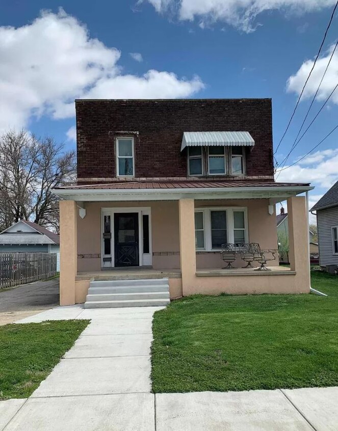
222 S Vine St
Kewanee, IL 61443
Favorites
222 S Vine St

Favorites
Check Back Soon for Upcoming Availability
| Beds | Baths | Average SF |
|---|---|---|
| 1 Bedroom 1 Bedroom 1 Br | 1 Bath 1 Bath 1 Ba | 100 SF |
| 3 Bedrooms 3 Bedrooms 3 Br | 1 Bath 1 Bath 1 Ba | 750 SF |
Fees and Policies
The fees listed below are community-provided and may exclude utilities or add-ons. All payments are made directly to the property and are non-refundable unless otherwise specified.
- Parking
-
Surface Lot--
Details
Utilities Included
-
Gas
-
Water
-
Electricity
-
Heat
-
Trash Removal
-
Sewer
-
Air Conditioning
Property Information
-
2 units
-
Furnished Units Available
About 222 S Vine St Kewanee, IL 61443
Black Hawk East Students Welcome! All Utilities Included! Common space shared with other renter's.
222 S Vine St is an apartment community located in Henry County and the 61443 ZIP Code.
Apartment Features
Washer/Dryer
Air Conditioning
Microwave
Refrigerator
- Washer/Dryer
- Air Conditioning
- Heating
- Kitchen
- Microwave
- Refrigerator
- Furnished
- Laundry Facilities
- Deck
222 S Vine St,
Kewanee,
IL
61443
Amenities
- Washer/Dryer
- Air Conditioning
- Heating
- Kitchen
- Microwave
- Refrigerator
- Furnished
- Laundry Facilities
- Deck
Expenses
Utilities Included
Gas, Water, Electricity, Heat, Trash Removal, Sewer, Air Conditioning
Included
Education
| Colleges & Universities | Distance | ||
|---|---|---|---|
| Colleges & Universities | Distance | ||
| Drive: | 65 min | 45.8 mi |
222 S Vine St is within 65 minutes or 45.8 miles from Black Hawk College.
Walkability Near 222 S Vine St Kewanee, IL 61443
Getting Around
 What do Walkability, Transit, Drivability, and Bikeability mean?
Walkability measures the walking distance to day-to-day needs.
Transit measures access to public transportation.
Drivability measures congestion, parking availability, and access to major roads.
Bikeability measures the suitability for cycling.
How It Works
What do Walkability, Transit, Drivability, and Bikeability mean?
Walkability measures the walking distance to day-to-day needs.
Transit measures access to public transportation.
Drivability measures congestion, parking availability, and access to major roads.
Bikeability measures the suitability for cycling.
How It Works
Fairly Walkable
Walkability
40
/ 100
Exceptionally Drivable
Drivability
100
/ 100
Somewhat Bikeable
Bikeability
30
/ 100
Scores provided by
-
Soundscore™
-
/ 100
Traffic
-Airport
-Businesses
-Scores provided by
HowLoud What is a Sound Score Rating? A Sound Score Rating aggregates noise caused by vehicle traffic, airplane traffic and local sources. How It WorksSimilar Rentals Nearby

What Are Walk Score®, Transit Score®, and Bike Score® Ratings?
Walk Score® measures the walkability of any address. Transit Score® measures access to public transit. Bike Score® measures the bikeability of any address.
What is a Sound Score Rating?
A Sound Score Rating aggregates noise caused by vehicle traffic, airplane traffic and local sources.

222 S Vine St
Kewanee, IL 61443