

$8,000
/ Month
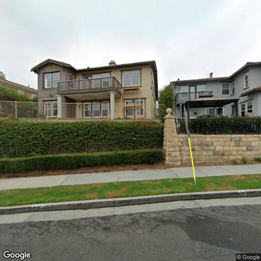
2209 Westwind Way
Signal Hill, CA 90755
2 Weeks Ago
|
Edit
Favorites
2209 Westwind Way

Favorites
Check Back Soon for Upcoming Availability
| Beds | Baths | Average SF |
|---|---|---|
| 4 Bedrooms 4 Bedrooms 4 Br | 4 Baths 4 Baths 4 Ba | — |
About This Property
If you're moving to Signal Hill, CA, this great property could be your new rental. This rental is located at 2209 Westwind Way in Signal Hill. Stop searching and find your new home. Contact us to learn more about this property.
2209 Westwind Way is a house located in Los Angeles County and the 90755 ZIP Code. This area is served by the Long Beach Unified attendance zone.
Location
Get Directions
A family-friendly suburb only four miles northeast of Long Beach, Signal Hill is known for its beautiful neighborhood parks, abundant shopping opportunities, and excellent public school district. The stately homes and upscale apartments for rent boast luxurious living in one of the most beautiful cities in the state. Signal Hill Park, Hilltop Park, and Discovery Well Park, and more offer locals beautiful green spaces, scenic walking trails, dog parks, and so much more. Towne Center East features both chain and independent retailers and restaurants, with an array of businesses and shops at the north end of town as well.
Residents of Signal Hill have immediate access to California’s Pacific Coast Highway, San Diego Freeway, and nearby Interstate 710. In just minutes, residents of Signal Hill can enjoy Long Beach’s gorgeous sandy shoreline, waterfront parks, major attractions, and abundant shopping, dining, and entertainment options.
Learn more about living in Signal Hill
Education
| Colleges & Universities | Distance | ||
|---|---|---|---|
| Colleges & Universities | Distance | ||
| Drive: | 4 min | 1.2 mi | |
| Drive: | 8 min | 3.8 mi | |
| Drive: | 9 min | 4.1 mi | |
| Drive: | 15 min | 8.3 mi |
2209 Westwind Way is within 4 minutes or 1.2 miles from Long Beach City Coll., Coast. It is also near Cal State Long Beach and Long Beach City Coll..
Schools


Public Elementary School
Grades K-6
603 Students
Nearby
Public Elementary School
Grades K-5
657 Students
Attendance Zone
Public Middle School
Grades 6-8
834 Students
Attendance Zone
Public High School
Grades 9-12
3,515 Students
Attendance Zone
Private Elementary School
Grades PK-5
59 Students
Nearby
Private Elementary, Middle & High School
Grades K-12
Nearby
Private Elementary & Middle School
Grades K-8
172 Students
Nearby
School data provided by
 The GreatSchools Rating helps parents compare schools within a state based on a variety of school quality indicators and provides a helpful picture of how effectively each school serves all of its students. Ratings are on a scale of 1 (below average) to 10 (above average) and can include test scores, college readiness, academic progress, advanced courses, equity, discipline and attendance data. We also advise parents to visit schools, consider other information on school performance and programs, and consider family needs as part of the school selection process.
View GreatSchools Rating Methodology
Data provided by GreatSchools.org © 2025. All rights reserved.
View GreatSchools Rating Methodology
Data provided by GreatSchools.org © 2025. All rights reserved.
Transportation options available in Signal Hill include Willow Station, located 2.2 miles from 2209 Westwind Way. 2209 Westwind Way is near Long Beach (Daugherty Field), located 2.1 miles or 5 minutes away, and Los Angeles International, located 21.2 miles or 29 minutes away.
| Transit / Subway | Distance | ||
|---|---|---|---|
| Transit / Subway | Distance | ||
|
|
Drive: | 5 min | 2.2 mi |
|
|
Drive: | 6 min | 2.4 mi |
|
|
Drive: | 7 min | 2.9 mi |
|
|
Drive: | 7 min | 3.2 mi |
|
|
Drive: | 9 min | 3.3 mi |
| Commuter Rail | Distance | ||
|---|---|---|---|
| Commuter Rail | Distance | ||
|
|
Drive: | 27 min | 15.2 mi |
|
|
Drive: | 25 min | 15.3 mi |
|
|
Drive: | 27 min | 17.1 mi |
|
|
Drive: | 29 min | 18.6 mi |
|
|
Drive: | 31 min | 18.6 mi |
| Airports | Distance | ||
|---|---|---|---|
| Airports | Distance | ||
|
Long Beach (Daugherty Field)
|
Drive: | 5 min | 2.1 mi |
|
Los Angeles International
|
Drive: | 29 min | 21.2 mi |
Time and distance from 2209 Westwind Way.
| Shopping Centers | Distance | ||
|---|---|---|---|
| Shopping Centers | Distance | ||
| Walk: | 10 min | 0.5 mi | |
| Walk: | 13 min | 0.7 mi | |
| Walk: | 13 min | 0.7 mi |
2209 Westwind Way has 3 shopping centers within 0.7 mile, which is about a 13-minute walk. The miles and minutes will be for the farthest away property.
| Parks and Recreation | Distance | ||
|---|---|---|---|
| Parks and Recreation | Distance | ||
|
Earl Burns Miller Japanese Garden
|
Drive: | 8 min | 3.6 mi |
|
Colorado Lagoon
|
Drive: | 8 min | 3.6 mi |
|
Aquarium of the Pacific
|
Drive: | 11 min | 4.2 mi |
|
El Dorado Nature Center
|
Drive: | 9 min | 4.7 mi |
|
El Dorado East Regional Park
|
Drive: | 10 min | 4.9 mi |
2209 Westwind Way has 5 parks within 4.9 miles, including Colorado Lagoon, Earl Burns Miller Japanese Garden, and Aquarium of the Pacific.
| Hospitals | Distance | ||
|---|---|---|---|
| Hospitals | Distance | ||
| Drive: | 3 min | 1.4 mi | |
| Drive: | 4 min | 1.8 mi | |
| Drive: | 4 min | 1.8 mi |
2209 Westwind Way has 3 hospitals within 1.8 miles, the nearest is Ocean View Psychiatric Health Facility which is 1.4 miles away and a 3 minute drive.
| Military Bases | Distance | ||
|---|---|---|---|
| Military Bases | Distance | ||
| Drive: | 18 min | 10.9 mi | |
| Drive: | 22 min | 11.0 mi |
2209 Westwind Way is 10.9 miles from Los Alamitos Army Airfield, and is convenient to other military bases, including Long Beach Naval Station.
You May Also Like
Similar Rentals Nearby


What Are Walk Score®, Transit Score®, and Bike Score® Ratings?
Walk Score® measures the walkability of any address. Transit Score® measures access to public transit. Bike Score® measures the bikeability of any address.
What is a Sound Score Rating?
A Sound Score Rating aggregates noise caused by vehicle traffic, airplane traffic and local sources
2209 Westwind Way
Signal Hill, CA 90755