$6,100
Total Monthly Price3 Beds, 2 Baths, 1,368 sq ft


Bedrooms
3
Bathrooms
1.5
Square Feet
1,624 sq ft
Available
Available Nov 1

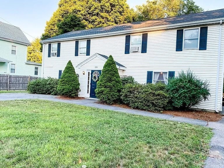
Beautifully Updated Townhome for Rent in the Heart of Natick! Move right in to this clean,bright,and updated duplex-style townhome! Located in the heart of Natick,this lovely two-unit property offers a perfect blend of comfort and convenience. Featuring three spacious bedrooms and one and a half bathrooms,this home is filled with natural light thanks to its many large windows. Enjoy cooking in the updated kitchen,relax on newer flooring,and take advantage of the spacious backyard — perfect for outdoor gatherings,pets,or simply unwinding. With ample parking,this home offers both functionality and charm. Don’t miss this opportunity to live in a well-maintained,move-in ready home in a prime location close to shopping,dining,schools,and public transportation. MLS# 73439298
220 Hartford St is a townhome located in Middlesex County and the 01760 ZIP Code. This area is served by the Natick attendance zone.
Year Built
Bedrooms and Bathrooms
Home Design
Interior Spaces
Kitchen
Laundry
Listing and Financial Details
Location
Outdoor Features
Parking
Utilities
Amenities
Overview
Pet Policy
Recreation
The fees below are based on community-supplied data and may exclude additional fees and utilities.
Just west of Boston and East of Worcester sits Metro West, a region that houses a group of towns and cities with significant historical backgrounds. A total of 19 municipalities make up the core of this community, but other municipalities are considered to be a part of the Interstate 495/Metro West Corridor.
Learn more about living in Metro West| Colleges & Universities | Distance | ||
|---|---|---|---|
| Colleges & Universities | Distance | ||
| Drive: | 6 min | 3.0 mi | |
| Drive: | 14 min | 6.0 mi | |
| Drive: | 15 min | 7.9 mi | |
| Drive: | 21 min | 12.3 mi |
 The GreatSchools Rating helps parents compare schools within a state based on a variety of school quality indicators and provides a helpful picture of how effectively each school serves all of its students. Ratings are on a scale of 1 (below average) to 10 (above average) and can include test scores, college readiness, academic progress, advanced courses, equity, discipline and attendance data. We also advise parents to visit schools, consider other information on school performance and programs, and consider family needs as part of the school selection process.
Transportation options available in Natick include Woodland Station, located 9.2 miles from 220 Hartford St. 220 Hartford St is near General Edward Lawrence Logan International, located 24.4 miles or 36 minutes away, and Worcester Regional, located 27.0 miles or 46 minutes away.
| Transit / Subway | Distance | ||
|---|---|---|---|
| Transit / Subway | Distance | ||
|
|
Drive: | 16 min | 9.2 mi |
|
|
Drive: | 18 min | 9.3 mi |
|
|
Drive: | 18 min | 9.9 mi |
|
|
Drive: | 19 min | 10.5 mi |
| Commuter Rail | Distance | ||
|---|---|---|---|
| Commuter Rail | Distance | ||
|
|
Drive: | 3 min | 1.4 mi |
|
|
Drive: | 4 min | 1.6 mi |
|
|
Drive: | 5 min | 2.2 mi |
|
|
Drive: | 7 min | 3.7 mi |
|
|
Drive: | 17 min | 5.9 mi |
| Airports | Distance | ||
|---|---|---|---|
| Airports | Distance | ||
|
General Edward Lawrence Logan International
|
Drive: | 36 min | 24.4 mi |
|
Worcester Regional
|
Drive: | 46 min | 27.0 mi |
Time and distance from 220 Hartford St.
| Shopping Centers | Distance | ||
|---|---|---|---|
| Shopping Centers | Distance | ||
| Drive: | 3 min | 1.5 mi | |
| Drive: | 3 min | 1.8 mi | |
| Drive: | 4 min | 2.1 mi |
| Parks and Recreation | Distance | ||
|---|---|---|---|
| Parks and Recreation | Distance | ||
|
Callahan State Park
|
Drive: | 9 min | 4.8 mi |
|
Hop Brook Natural Area
|
Drive: | 10 min | 5.1 mi |
|
Cowassock Woods and Ashland Town Forest
|
Drive: | 11 min | 5.2 mi |
|
Garden in the Woods
|
Drive: | 12 min | 5.7 mi |
|
Cochituate State Park
|
Drive: | 17 min | 10.7 mi |
| Hospitals | Distance | ||
|---|---|---|---|
| Hospitals | Distance | ||
| Drive: | 3 min | 1.3 mi | |
| Drive: | 15 min | 9.0 mi | |
| Drive: | 17 min | 9.8 mi |
| Military Bases | Distance | ||
|---|---|---|---|
| Military Bases | Distance | ||
| Drive: | 7 min | 3.3 mi | |
| Drive: | 32 min | 17.3 mi |
$6,100
Total Monthly Price3 Beds, 2 Baths, 1,368 sq ft
$3,820 - $6,160
Total Monthly Price3 Beds
$3,145 - $5,795
Total Monthly Price3 Beds
$3,800 - $4,000
Plus Fees3 Beds
What Are Walk Score®, Transit Score®, and Bike Score® Ratings?
Walk Score® measures the walkability of any address. Transit Score® measures access to public transit. Bike Score® measures the bikeability of any address.
What is a Sound Score Rating?
A Sound Score Rating aggregates noise caused by vehicle traffic, airplane traffic and local sources