
$1,450
/ Month
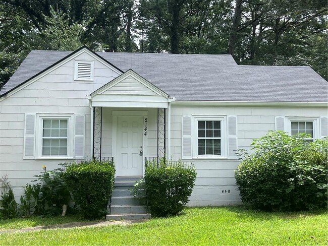
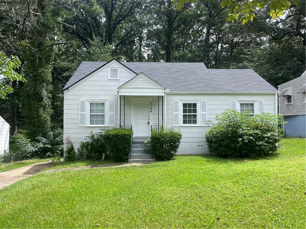
2144 Mulberry St
Atlanta, GA 30344
Today
|
Edit
Favorites
404-518-1580
-
Bedrooms
3
-
Bathrooms
2
-
Square Feet
1,120 sq ft
-
Available
Available Now
Highlights
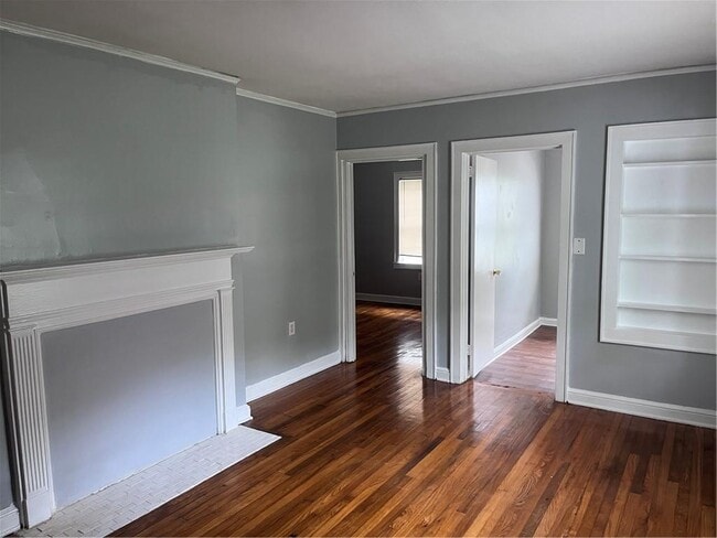
- Wood Flooring
- Loft
- White Kitchen Cabinets
- Ceiling height of 9 feet on the main level
- Bungalow
- Central Heating and Cooling System
2144 Mulberry St

Favorites
About This Home
Available Now
Newly renovated 3BR/2BA bungalow with fresh roof,HVAC,plumbing,and more! Minutes from the East Point square with the shops and dining. Also minutes from Westside Beltline and downtown ATL. Deep lot with lots of privacy,upstairs attic storage,flex or office room. Available now!
2144 Mulberry St is a house located in Fulton County and the 30344 ZIP Code. This area is served by the Fulton County attendance zone.
* Price shown is base rent. Excludes user-selected optional fees and variable or usage-based fees and required charges due at or prior to move-in or at move-out. Price, availability, fees, and any applicable rent special are subject to change without notice.
* Square footage definitions vary. Displayed square footage is approximate.
Home Details
Home Type
Single Family Detached Home
Year Built
Built in 1945
Basement
Crawl Space
Bedrooms and Bathrooms
3 Main Level Bedrooms
2 Full Bathrooms
Home Design
Bungalow
Cement Siding
Composition Roof
Interior Spaces
Wood Flooring
Loft
Bonus Room
Ceiling height of 9 feet on the main level
1,120 Sq Ft Home
1.5-Story Property
Kitchen
White Kitchen Cabinets
Gas Range
Dishwasher
Laminate Countertops
Laundry
Laundry in Kitchen
Listing and Financial Details
Security Deposit $500
12 Month Lease Term
$65 Application Fee
Assessor Parcel Number 14 016600010463
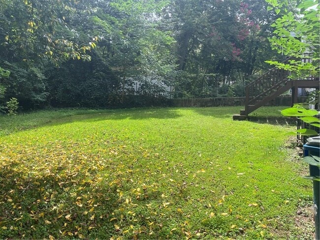
Lot Details
0.33 Acre Lot
No Common Walls
Level Lot
Parking
Driveway Level
Parking Pad
Schools
Tuskegee Airman Global Academy Elementary School
Paul D. West Middle School
Tri-Cities High School
Utilities
Central Heating and Cooling System
Gas Water Heater
Community Details
Overview
Application Fee Required
Connelly Subdivision
Pet Policy
Call for details about the types of pets allowed
Pet Deposit $500
Contact
- Listed by KEITH GORDON | Gordon Street Realty,LLC.
- Phone Number
- Contact
-
Source
 First Multiple Listing Service, Inc.
Copyright © 2025 First Multiple Listing Service, Inc. All rights reserved. All information provided by the listing agent/broker is deemed reliable but is not guaranteed and should be independently verified.
Location
Get Directions
Amenities
- Dishwasher
- Range
- Refrigerator
Aerotropolis refers to an array of Southside Atlanta communities surrounding Hartsfield-Jackson Atlanta International Airport, the world’s busiest airport. The cities of College Park, Chattahoochee Hills, East Point, Fairburn, Forest Park, Union City, Hapeville, Morrow, and Palmetto are all a part of the Aerotropolis Alliance, working together on initiatives to improve their respective communities.
Aerotropolis’ close proximity to the airport makes the region an ideal choice for local employees and frequent travelers alike. A wide variety of rentals are available throughout the region, from luxury apartments and cozy condos to charming townhomes and spacious houses. Getting around from Aerotropolis is easy with access to I-75, I-85, and I-285.
Learn more about living in Aerotropolis
Education
| Colleges & Universities | Distance | ||
|---|---|---|---|
| Colleges & Universities | Distance | ||
| Drive: | 9 min | 4.3 mi | |
| Drive: | 10 min | 5.0 mi | |
| Drive: | 12 min | 5.0 mi | |
| Drive: | 12 min | 5.3 mi |
2144 Mulberry St is within 9 minutes or 4.3 miles from Atlanta Metropolitan State. It is also near Atlanta Technical College and Morehouse School of Medicine.
Schools


Public Elementary School
Grades PK-5
538 Students
Attendance Zone
Public Middle School
Grades 6-8
803 Students
Attendance Zone
Public High School
Grades 9-12
1,483 Students
Attendance Zone
Private Elementary, Middle & High School
Grades PK-12
Nearby
Private Elementary School
Grades PK-6
32 Students
Nearby
School data provided by
 The GreatSchools Rating helps parents compare schools within a state based on a variety of school quality indicators and provides a helpful picture of how effectively each school serves all of its students. Ratings are on a scale of 1 (below average) to 10 (above average) and can include test scores, college readiness, academic progress, advanced courses, equity, discipline and attendance data. We also advise parents to visit schools, consider other information on school performance and programs, and consider family needs as part of the school selection process.
View GreatSchools Rating Methodology
Data provided by GreatSchools.org © 2025. All rights reserved.
View GreatSchools Rating Methodology
Data provided by GreatSchools.org © 2025. All rights reserved.
Transportation options available in Atlanta include East Point, located 1.9 miles from 2144 Mulberry St. 2144 Mulberry St is near Hartsfield - Jackson Atlanta International, located 7.2 miles or 15 minutes away.
| Transit / Subway | Distance | ||
|---|---|---|---|
| Transit / Subway | Distance | ||
|
|
Drive: | 5 min | 1.9 mi |
|
|
Drive: | 6 min | 2.6 mi |
|
|
Drive: | 6 min | 2.9 mi |
|
|
Drive: | 7 min | 3.7 mi |
|
|
Drive: | 8 min | 4.3 mi |
| Commuter Rail | Distance | ||
|---|---|---|---|
| Commuter Rail | Distance | ||
|
|
Drive: | 19 min | 11.8 mi |
| Airports | Distance | ||
|---|---|---|---|
| Airports | Distance | ||
|
Hartsfield - Jackson Atlanta International
|
Drive: | 15 min | 7.2 mi |
Time and distance from 2144 Mulberry St.
| Shopping Centers | Distance | ||
|---|---|---|---|
| Shopping Centers | Distance | ||
| Walk: | 13 min | 0.7 mi | |
| Walk: | 15 min | 0.8 mi | |
| Walk: | 15 min | 0.8 mi |
2144 Mulberry St has 3 shopping centers within 0.8 mile, which is about a 15-minute walk. The miles and minutes will be for the farthest away property.
| Parks and Recreation | Distance | ||
|---|---|---|---|
| Parks and Recreation | Distance | ||
|
West Atlanta Watershed Alliance (WAWA)
|
Drive: | 8 min | 3.2 mi |
|
Cascade Springs Nature Preserve
|
Drive: | 8 min | 3.3 mi |
|
Atlanta BeltLine Southwest Connector Spur Trail
|
Drive: | 10 min | 4.0 mi |
|
Park Pride
|
Drive: | 11 min | 5.8 mi |
|
The Georgia Capitol Museum
|
Drive: | 12 min | 6.3 mi |
2144 Mulberry St has 5 parks within 6.3 miles, including Cascade Springs Nature Preserve, West Atlanta Watershed Alliance (WAWA), and Atlanta BeltLine Southwest Connector Spur Trail.
| Hospitals | Distance | ||
|---|---|---|---|
| Hospitals | Distance | ||
| Drive: | 13 min | 6.7 mi | |
| Drive: | 14 min | 7.4 mi | |
| Drive: | 15 min | 8.8 mi |
2144 Mulberry St has 3 hospitals within 8.8 miles, the nearest is Grady Memorial Hospital which is 6.7 miles away and a 13 minute drive.
| Military Bases | Distance | ||
|---|---|---|---|
| Military Bases | Distance | ||
| Drive: | 7 min | 3.2 mi | |
| Drive: | 26 min | 13.3 mi |
2144 Mulberry St is 3.2 miles from Fort McPherson, and is convenient to other military bases, including Fort Gillem.
You May Also Like
Similar Rentals Nearby
-
-
-
1 / 58

-
-
-
-
-
-

-


What Are Walk Score®, Transit Score®, and Bike Score® Ratings?
Walk Score® measures the walkability of any address. Transit Score® measures access to public transit. Bike Score® measures the bikeability of any address.
What is a Sound Score Rating?
A Sound Score Rating aggregates noise caused by vehicle traffic, airplane traffic and local sources
2144 Mulberry St
Atlanta, GA 30344