$2,400
/ Month
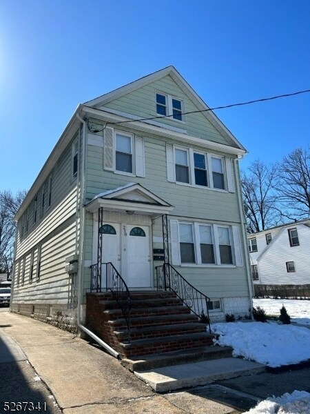
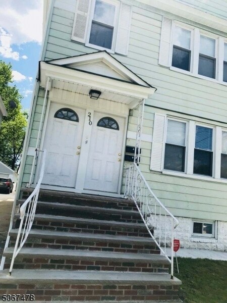
210 E 9th Ave
Roselle, NJ 07203
Favorites
-
Bedrooms
3
-
Bathrooms
1
-
Square Feet
--
210 E 9th Ave

Favorites
About This Home
---- SCHEDULE A SHOWING ONLINE AT: ----
210 E 9th Ave is a condo located in Union County and the 07203 ZIP Code.
* Price shown is base rent. Excludes user-selected optional fees and variable or usage-based fees and required charges due at or prior to move-in or at move-out. Price, availability, fees, and any applicable rent special are subject to change without notice.
* Square footage definitions vary. Displayed square footage is approximate.
Contact
- Listed by Locayt
Location
Get Directions
Tucked into Union County about 18 miles from New York City, Roselle is a compact New Jersey borough that carries a lot of history in just three square miles. Incorporated in 1894, the borough has deep roots, dating back to the original Elizabethtown settlement in 1664, and that fascinating history adds a unique character to the community.
Roselle’s streets are largely residential and tree-lined, giving the borough a settled, neighborhood feel while keeping commuters within reach of Newark and New York City. The housing mix reflects the area’s established character, with classic single-family homes, two- and three-family houses, and a selection of apartment communities offering studio through multi-bedroom floor plans. Renters looking for well-maintained spaces without the density of a major metro will find solid options here.
Learn more about living in Roselle
Education
| Colleges & Universities | Distance | ||
|---|---|---|---|
| Colleges & Universities | Distance | ||
| Drive: | 8 min | 2.9 mi | |
| Drive: | 9 min | 3.5 mi | |
| Drive: | 13 min | 4.6 mi | |
| Drive: | 20 min | 10.7 mi |
210 E 9th Ave is within 8 minutes or 2.9 miles from Union County Coll., Elizabeth. It is also near Kean University and Union County College, Cranford.
Transportation options available in Roselle include Military Park, located 9.5 miles from 210 E 9th Ave. 210 E 9th Ave is near Newark Liberty International, located 10.1 miles or 19 minutes away, and LaGuardia, located 27.8 miles or 52 minutes away.
| Transit / Subway | Distance | ||
|---|---|---|---|
| Transit / Subway | Distance | ||
|
|
Drive: | 17 min | 9.5 mi |
|
|
Drive: | 17 min | 10.1 mi |
|
|
Drive: | 18 min | 10.6 mi |
| Drive: | 19 min | 11.2 mi | |
|
|
Drive: | 21 min | 12.4 mi |
| Commuter Rail | Distance | ||
|---|---|---|---|
| Commuter Rail | Distance | ||
|
|
Drive: | 5 min | 1.8 mi |
|
|
Drive: | 5 min | 2.1 mi |
|
|
Drive: | 8 min | 3.0 mi |
|
|
Drive: | 8 min | 3.2 mi |
|
|
Drive: | 9 min | 3.9 mi |
| Airports | Distance | ||
|---|---|---|---|
| Airports | Distance | ||
|
Newark Liberty International
|
Drive: | 19 min | 10.1 mi |
|
LaGuardia
|
Drive: | 52 min | 27.8 mi |
Getting Around
 What do Walkability, Transit, Drivability, and Bikeability mean?
Walkability measures the walking distance to day-to-day needs.
Transit measures access to public transportation.
Drivability measures congestion, parking availability, and access to major roads.
Bikeability measures the suitability for cycling.
How It Works
What do Walkability, Transit, Drivability, and Bikeability mean?
Walkability measures the walking distance to day-to-day needs.
Transit measures access to public transportation.
Drivability measures congestion, parking availability, and access to major roads.
Bikeability measures the suitability for cycling.
How It Works
Moderately Walkable
Walkability
70
/ 100
Some Public Transit
Transit
40
/ 100
Moderately Drivable
Drivability
60
/ 100
Moderately Bikeable
Bikeability
60
/ 100
Scores provided by
-
Soundscore™
-
/ 100
Traffic
-Airport
-Businesses
-Scores provided by
HowLoud What is a Sound Score Rating? A Sound Score Rating aggregates noise caused by vehicle traffic, airplane traffic and local sources. How It WorksTime and distance from 210 E 9th Ave.
| Shopping Centers | Distance | ||
|---|---|---|---|
| Shopping Centers | Distance | ||
| Walk: | 19 min | 1.0 mi | |
| Drive: | 5 min | 1.4 mi | |
| Drive: | 4 min | 1.4 mi |
210 E 9th Ave has 3 shopping centers within 1.4 miles, which is about a 4-minute drive. The miles and minutes will be for the farthest away property.
| Parks and Recreation | Distance | ||
|---|---|---|---|
| Parks and Recreation | Distance | ||
|
William Miller Sperry Observatory
|
Drive: | 11 min | 4.4 mi |
|
Hawk Rise Sanctuary
|
Drive: | 11 min | 4.5 mi |
|
Merrill Park
|
Drive: | 15 min | 6.2 mi |
|
Liberty State Park
|
Drive: | 15 min | 7.2 mi |
|
Staten Island Industrial Park
|
Drive: | 15 min | 8.6 mi |
210 E 9th Ave has 5 parks within 8.6 miles, including William Miller Sperry Observatory, Hawk Rise Sanctuary, and Merrill Park.
| Hospitals | Distance | ||
|---|---|---|---|
| Hospitals | Distance | ||
| Drive: | 8 min | 2.8 mi | |
| Drive: | 9 min | 3.6 mi | |
| Drive: | 14 min | 6.3 mi |
210 E 9th Ave has 3 hospitals within 6.3 miles, the nearest is Trinitas Regional Medical Center which is 2.8 miles away and a 8 minute drive.
| Military Bases | Distance | ||
|---|---|---|---|
| Military Bases | Distance | ||
| Drive: | 17 min | 5.8 mi | |
| Drive: | 15 min | 6.2 mi | |
| Drive: | 24 min | 13.9 mi |
210 E 9th Ave has 3 military bases within 13.9 miles, the nearest is Tamdques Reservation which is 5.8 miles away and a 17 minute drive.
You May Also Like
How do I access Social Services in New Jersey?
Statewide service is free, confidential, multilingual and always open. Three easy ways to reach Social Services in NJ: Dial 2-1-1; text your zip code to 898-211; or chat at https://www.nj211.org
Similar Rentals Nearby


What Are Walk Score®, Transit Score®, and Bike Score® Ratings?
Walk Score® measures the walkability of any address. Transit Score® measures access to public transit. Bike Score® measures the bikeability of any address.
What is a Sound Score Rating?
A Sound Score Rating aggregates noise caused by vehicle traffic, airplane traffic and local sources.

210 E 9th Ave
Roselle, NJ 07203