
$1,800
/ Month
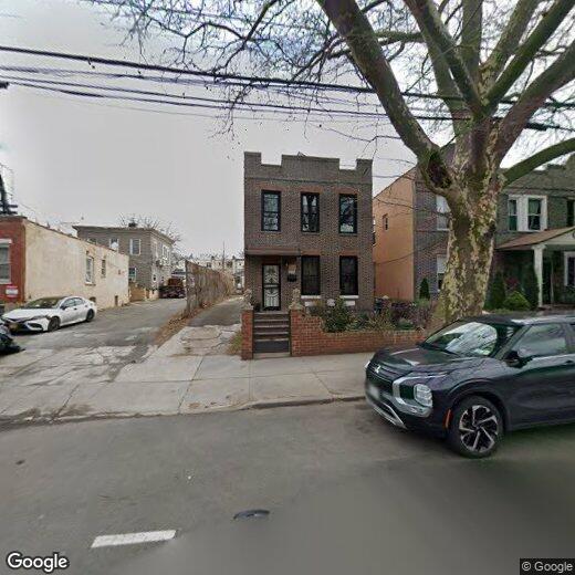
21-17-21-21 21st St Unit 1 REAR
Queens, NY 11105
2 Weeks Ago
|
Edit
Favorites
21 STREET

Favorites
Check Back Soon for Upcoming Availability
| Beds | Baths | Average SF |
|---|---|---|
| 1 Bedroom 1 Bedroom 1 Br | 1 Bath 1 Bath 1 Ba | — |
About This Property
Description coming soon, please contact your Highline Residential agent for more information===Ref:685950===
21 STREET is an apartment community located in Queens County and the 11105 ZIP Code.
21-17-21-21 21st St,
Queens,
NY
11105
Just north of Astoria, Ditmars Steinway is a popular neighborhood for those searching for affordable apartments in New York.
The Steinway and Sons piano factory calls this community home. Visitors are encouraged to tour its showroom as well as the Steinway Mansion, which was once owned by one of the founder’s sons. In addition to piano making, Ditmars Steinway has a bustling business district that’s dotted with bakeries, small businesses, and Greek-inspired restaurants.
When it comes to commutes, locals are comforted by the direct access to N & W train services. Astoria Park – the largest green space in Astoria – is a scenic spot with views of the East River, Hell Gate Bridge, and Randalls Island. LaGuardia Airport is only a 10-minute drive east on Interstate 278.
Learn more about living in Ditmars SteinwayBelow are rent ranges for similar nearby apartments
| Beds | Average Size | Lowest | Typical | Premium |
|---|---|---|---|---|
| Studio Studio Studio | 632 Sq Ft | $1,850 | $2,497 | $5,255 |
| 1 Bed 1 Bed 1 Bed | 982 Sq Ft | $1,000 | $2,461 | $3,150 |
| 2 Beds 2 Beds 2 Beds | 1074 Sq Ft | $2,500 | $3,100 | $4,100 |
| 3 Beds 3 Beds 3 Beds | 1886 Sq Ft | $3,500 | $3,933 | $4,500 |
| 4 Beds 4 Beds 4 Beds | 1417 Sq Ft | $1,400 | $4,383 | $6,500 |
Education
| Colleges & Universities | Distance | ||
|---|---|---|---|
| Colleges & Universities | Distance | ||
| Drive: | 11 min | 4.8 mi | |
| Drive: | 11 min | 4.9 mi | |
| Drive: | 11 min | 5.2 mi | |
| Drive: | 11 min | 5.4 mi |
21 STREET is within 11 minutes or 4.8 miles from Weill Cornell Medical College. It is also near Marymount Manhattan College and Hunter College.
Transportation options available in Queens include Astoria-Ditmars Blvd, located 0.7 mile from 21 STREET. 21 STREET is near LaGuardia, located 3.8 miles or 10 minutes away, and John F Kennedy International, located 15.0 miles or 23 minutes away.
| Transit / Subway | Distance | ||
|---|---|---|---|
| Transit / Subway | Distance | ||
| Walk: | 12 min | 0.7 mi | |
| Drive: | 3 min | 1.1 mi | |
| Drive: | 4 min | 1.5 mi | |
| Drive: | 5 min | 1.9 mi | |
|
|
Drive: | 10 min | 4.4 mi |
| Commuter Rail | Distance | ||
|---|---|---|---|
| Commuter Rail | Distance | ||
|
|
Drive: | 8 min | 3.4 mi |
|
|
Drive: | 8 min | 3.7 mi |
|
|
Drive: | 10 min | 4.3 mi |
|
|
Drive: | 10 min | 5.6 mi |
|
|
Drive: | 15 min | 6.7 mi |
| Airports | Distance | ||
|---|---|---|---|
| Airports | Distance | ||
|
LaGuardia
|
Drive: | 10 min | 3.8 mi |
|
John F Kennedy International
|
Drive: | 23 min | 15.0 mi |
Walkability Near 21 STREET
Getting Around
 What do Walkability, Transit, Drivability, and Bikeability mean?
Walkability measures the walking distance to day-to-day needs.
Transit measures access to public transportation.
Drivability measures congestion, parking availability, and access to major roads.
Bikeability measures the suitability for cycling.
How It Works
What do Walkability, Transit, Drivability, and Bikeability mean?
Walkability measures the walking distance to day-to-day needs.
Transit measures access to public transportation.
Drivability measures congestion, parking availability, and access to major roads.
Bikeability measures the suitability for cycling.
How It Works
Exceptionally Walkable
Walkability
100
/ 100
Strong Public Transit
Transit
80
/ 100
Moderately Drivable
Drivability
60
/ 100
Moderately Bikeable
Bikeability
70
/ 100
Scores provided by
-
Soundscore™
-
/ 100
Traffic
-Airport
-Businesses
-Scores provided by
HowLoud What is a Sound Score Rating? A Sound Score Rating aggregates noise caused by vehicle traffic, airplane traffic and local sources. How It WorksTime and distance from 21 STREET.
| Shopping Centers | Distance | ||
|---|---|---|---|
| Shopping Centers | Distance | ||
| Drive: | 4 min | 1.2 mi | |
| Drive: | 5 min | 1.7 mi | |
| Drive: | 8 min | 2.7 mi |
21 STREET has 3 shopping centers within 2.7 miles, which is about a 8-minute drive. The miles and minutes will be for the farthest away property.
| Parks and Recreation | Distance | ||
|---|---|---|---|
| Parks and Recreation | Distance | ||
|
Astoria Park
|
Walk: | 11 min | 0.6 mi |
|
Hallets Cove Playground
|
Drive: | 4 min | 1.5 mi |
|
Socrates Sculpture Park
|
Drive: | 4 min | 1.8 mi |
|
Thomas Jefferson Park
|
Drive: | 10 min | 4.6 mi |
|
Randall's Island Park
|
Drive: | 12 min | 5.1 mi |
21 STREET has 5 parks within 5.1 miles, including Astoria Park, Hallets Cove Playground, and Socrates Sculpture Park.
| Hospitals | Distance | ||
|---|---|---|---|
| Hospitals | Distance | ||
| Drive: | 11 min | 4.9 mi | |
| Drive: | 12 min | 5.3 mi | |
| Drive: | 12 min | 5.5 mi |
21 STREET has 3 hospitals within 5.5 miles, the nearest is Hospital for Special Surgery which is 4.9 miles away and a 11 minute drive.
| Military Bases | Distance | ||
|---|---|---|---|
| Military Bases | Distance | ||
| Drive: | 20 min | 9.7 mi | |
| Drive: | 25 min | 11.4 mi |
21 STREET is 9.7 miles from Fort Totten US Govt Reservation, and is convenient to other military bases, including Governors Island Support Center.
You May Also Like
Similar Rentals Nearby


What Are Walk Score®, Transit Score®, and Bike Score® Ratings?
Walk Score® measures the walkability of any address. Transit Score® measures access to public transit. Bike Score® measures the bikeability of any address.
What is a Sound Score Rating?
A Sound Score Rating aggregates noise caused by vehicle traffic, airplane traffic and local sources.
21-17-21-21 21st St
Queens, NY 11105