$2,295
/ Month
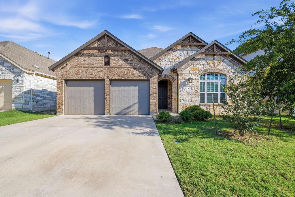
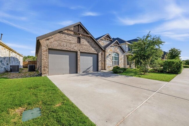
2032 Base Burner Path
Leander, TX 78641
Favorites
512-969-1000
-
Bedrooms
3
-
Bathrooms
2
-
Square Feet
1,596 sq ft
-
Available
Available Now
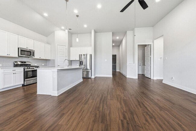
Highlights
- Two Primary Bathrooms
- Open Floorplan
- High Ceiling
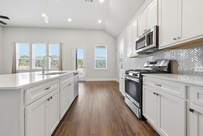
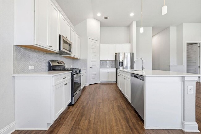
- Granite Countertops
- Covered Patio or Porch
- 2 Car Attached Garage
2032 Base Burner Path

Favorites
2032 Base Burner Path is a house located in Williamson County and the 78641 ZIP Code. This area is served by the Liberty Hill Independent School District attendance zone.
* Price shown is base rent. Excludes user-selected optional fees and variable or usage-based fees and required charges due at or prior to move-in or at move-out. Price, availability, fees, and any applicable rent special are subject to change without notice.
* Square footage definitions vary. Displayed square footage is approximate.
Home Details
Home Type
Single Family Detached Home
Year Built
Built in 2021
Bedrooms and Bathrooms
Two Primary Bathrooms
3 Main Level Bedrooms
Double Vanity
Walk-In Closet
2 Full Bathrooms
Flooring
Tile
Carpet
Home Design
Shingle Roof
Brick Exterior Construction
Masonry Siding
Stone Siding
Composition Roof
Slab Foundation
Home Security
Smart Thermostat
Fire and Smoke Detector
In Wall Pest System
Interior Spaces
Open Floorplan
High Ceiling
Recessed Lighting
1-Story Property
Ceiling Fan
1,596 Sq Ft Home
Wired For Sound
Blinds
Kitchen
Granite Countertops
Built-In Gas Oven
Built-In Oven
Built-In Gas Range
Dishwasher
Listing and Financial Details
Security Deposit $2,295
12 Month Lease Term
$40 Application Fee
Assessor Parcel Number 2032 Base Burner Path
Tax Block CC
Tenant pays for all utilities
Lot Details
6,970 Sq Ft Lot
West Facing Home
Wood Fence
Rain Sensor Irrigation System
Back Yard Fenced
Outdoor Features
Covered Patio or Porch
Rain Gutters
Parking
2 Car Attached Garage
Multiple Garage Doors
Garage Door Opener
Schools
Louinenoble Elementary School
Liberty Hill Middle School
Liberty Hill High School
Utilities
Central Heating and Cooling System
Underground Utilities
Heating System Uses Natural Gas
Community Details
Amenities
Common Area
Community Mailbox
Overview
Property has a Home Owners Association
Built by Brohn Homes
Bar W Ranch Subdivision
Pet Policy
Dogs and Cats Allowed
Pet Size Limit
Small pets allowed
Pet Deposit $350
Recreation
Trails
Fees and Policies
The fees listed below are community-provided and may exclude utilities or add-ons. All payments are made directly to the property and are non-refundable unless otherwise specified.
-
Dogs
-
Allowed
-
-
Cats
-
Allowed
-
Property Fee Disclaimer: Based on community-supplied data and independent market research. Subject to change without notice. May exclude fees for mandatory or optional services and usage-based utilities.
Contact
- Listed by Siva jyothi Rachumalla | FULL CIRCLE RE
- Phone Number
- Contact
-
Source
 Austin Board of REALTORS®
The information included in this listing is provided exclusively for consumers’ personal, non-commercial use and may not be used for any purpose other than to identify prospective properties consumers may be interested in purchasing. The information on each listing is furnished by the owner and deemed reliable to the best of his/her knowledge, but should be verified by the purchaser. ABoR, ACTRIS and Estately assume no responsibility for typographical errors, misprints or misinformation. This property listing is offered without respect to any protected classes in accordance with the law. Copyright © 2026.
Location
Get Directions
Located 22 miles northwest of Austin, Leander combines Hill Country scenery with suburban living. The city features established neighborhoods like Mason Creek, Travisso, and Crystal Falls, each offering their own mix of housing options from single-family homes to townhouses.
Parks and outdoor spaces define Leander's landscape, including Benbrook Ranch Park's skating facilities and Robin Bledsoe Park's pool and sports courts. The city's natural limestone formations and rolling hills provide scenic backdrops for hiking and biking trails throughout the area.
Archaeological significance adds to Leander's character, as the site of the "Leanderthal Lady" discovery represents one of North America's oldest burial sites. The MetroRail Red Line's Leander Station connects residents to downtown Austin, while major thoroughfares provide access to the region's employment centers.
Learn more about living in Leander
Amenities
- Dishwasher
- Carpet
- Tile Floors
Education
| Colleges & Universities | Distance | ||
|---|---|---|---|
| Colleges & Universities | Distance | ||
| Drive: | 19 min | 11.9 mi | |
| Drive: | 19 min | 12.6 mi | |
| Drive: | 24 min | 15.6 mi | |
| Drive: | 25 min | 17.3 mi |
2032 Base Burner Path is within 19 minutes or 11.9 miles from Southwestern University. It is also near Austin C.C., Cypress Creek and Austin C.C., Round Rock Campus.
Schools


Public Elementary School
Grades PK-5
711 Students
Nearby
Public Middle School
Grades 6-8
870 Students
Attendance Zone
Public High School
Grades 9-12
2,001 Students
Attendance Zone
Private Elementary School
Grades PK-5
165 Students
Nearby
Private Elementary & Middle School
Grades K-8
31 Students
Nearby
Private Elementary, Middle & High School
Grades PK-12
312 Students
Nearby
School data provided by
 The GreatSchools Rating helps parents compare schools within a state based on a variety of school quality indicators and provides a helpful picture of how effectively each school serves all of its students. Ratings are on a scale of 1 (below average) to 10 (above average) and can include test scores, college readiness, academic progress, advanced courses, equity, discipline and attendance data. We also advise parents to visit schools, consider other information on school performance and programs, and consider family needs as part of the school selection process.
View GreatSchools Rating Methodology
Data provided by GreatSchools.org © 2026. All rights reserved.
View GreatSchools Rating Methodology
Data provided by GreatSchools.org © 2026. All rights reserved.
Transportation options available in Leander include Leander Station, located 6.9 miles from 2032 Base Burner Path. 2032 Base Burner Path is near Robert Gray AAF, located 39.3 miles or 61 minutes away, and Austin-Bergstrom International, located 40.4 miles or 55 minutes away.
| Transit / Subway | Distance | ||
|---|---|---|---|
| Transit / Subway | Distance | ||
| Drive: | 12 min | 6.9 mi | |
| Drive: | 20 min | 12.1 mi |
| Commuter Rail | Distance | ||
|---|---|---|---|
| Commuter Rail | Distance | ||
|
|
Drive: | 39 min | 29.3 mi |
|
|
Drive: | 44 min | 32.3 mi |
| Airports | Distance | ||
|---|---|---|---|
| Airports | Distance | ||
|
Robert Gray AAF
|
Drive: | 61 min | 39.3 mi |
|
Austin-Bergstrom International
|
Drive: | 55 min | 40.4 mi |
Getting Around
 What do Walkability, Transit, Drivability, and Bikeability mean?
Walkability measures the walking distance to day-to-day needs.
Transit measures access to public transportation.
Drivability measures congestion, parking availability, and access to major roads.
Bikeability measures the suitability for cycling.
How It Works
What do Walkability, Transit, Drivability, and Bikeability mean?
Walkability measures the walking distance to day-to-day needs.
Transit measures access to public transportation.
Drivability measures congestion, parking availability, and access to major roads.
Bikeability measures the suitability for cycling.
How It Works
Not Walkable
Walkability
10
/ 100
Minimal Public Transit
Transit
0
/ 100
Exceptionally Drivable
Drivability
90
/ 100
Somewhat Bikeable
Bikeability
30
/ 100
Scores provided by
-
Soundscore™
-
/ 100
Traffic
-Airport
-Businesses
-Scores provided by
HowLoud What is a Sound Score Rating? A Sound Score Rating aggregates noise caused by vehicle traffic, airplane traffic and local sources. How It WorksTime and distance from 2032 Base Burner Path.
| Shopping Centers | Distance | ||
|---|---|---|---|
| Shopping Centers | Distance | ||
| Drive: | 2 min | 1.3 mi | |
| Drive: | 3 min | 1.6 mi | |
| Drive: | 3 min | 2.0 mi |
2032 Base Burner Path has 3 shopping centers within 2.0 miles, which is about a 3-minute drive. The miles and minutes will be for the farthest away property.
| Parks and Recreation | Distance | ||
|---|---|---|---|
| Parks and Recreation | Distance | ||
|
Garey Park
|
Drive: | 14 min | 5.8 mi |
|
Austin Steam Train
|
Drive: | 15 min | 9.2 mi |
|
Rivery Park
|
Drive: | 19 min | 11.2 mi |
|
Inner Space Cavern
|
Drive: | 18 min | 11.7 mi |
|
Chandler Park
|
Drive: | 21 min | 11.7 mi |
2032 Base Burner Path has 5 parks within 11.7 miles, including Garey Park, Austin Steam Train, and Inner Space Cavern.
| Hospitals | Distance | ||
|---|---|---|---|
| Hospitals | Distance | ||
| Drive: | 15 min | 9.2 mi | |
| Drive: | 19 min | 12.0 mi | |
| Drive: | 20 min | 12.5 mi |
2032 Base Burner Path has 3 hospitals within 12.5 miles, the nearest is Cedar Park Regional Medical Center which is 9.2 miles away and a 15 minute drive.
| Military Bases | Distance | ||
|---|---|---|---|
| Military Bases | Distance | ||
| Drive: | 66 min | 50.5 mi |
2032 Base Burner Path is 50.5 miles and a 66 minute drive from Fort Hood.
You May Also Like
-
Stillwell at Avery Centre
1400 Avery Nelson Pky
Round Rock, TX 78665
$2,560 - $4,136
3 Br 11.3 mi
-
Tricon Saddle Creek
5101 Sidesaddle Dr
Georgetown, TX 78626
$2,009 - $3,062
3-4 Br 12.2 mi
-
Beacon at Vine Creek Rental Homes
17817 Inglenook Dr
Pflugerville, TX 78660
$2,205 - $3,039 Total Monthly Price
3-5 Br 12 Month Lease 21.0 mi
Similar Rentals Nearby
-
-
3 Beds$2,181+Total Monthly PriceTotal Monthly Price NewPrices include base rent and required monthly fees of $80. Variable costs based on usage may apply.Base Rent:3 Beds$2,100+2 Months Free
Pets Allowed Dishwasher In Unit Washer & Dryer Maintenance on site Stainless Steel Appliances Granite Countertops
-
3 Beds$2,213Total Monthly PriceTotal Monthly Price NewPrices include base rent and required monthly fees of $207. Variable costs based on usage may apply.Base Rent:3 Beds$2,005+Discounts
Pets Allowed Pool In Unit Washer & Dryer Gated Online Services EV Charging Smoke Free
-
-
3 Beds$2,398+Total Monthly PriceTotal Monthly Price NewPrices include base rent and required monthly fees of $160. Variable costs based on usage may apply.Base Rent:3 Beds$2,238+Specials
-
3 Beds$2,848Total Monthly PriceTotal Monthly Price NewPrices include base rent and required monthly fees of $184. Variable costs based on usage may apply.Base Rent:3 Beds$2,663+2 Months Free
-
-
3 Beds$2,4294 Beds$2,454+Total Monthly PriceTotal Monthly Price NewPrices include base rent and required monthly fees of $105. Variable costs based on usage may apply.Base Rent:3 Beds$2,3244 Beds$2,349+2 Months Free
-
-
3 Beds$2,368+Total Monthly PriceTotal Monthly Price NewPrices include base rent and required monthly fees of $173. Variable costs based on usage may apply.Base Rent:3 Beds$2,195+2 Months Free


What Are Walk Score®, Transit Score®, and Bike Score® Ratings?
Walk Score® measures the walkability of any address. Transit Score® measures access to public transit. Bike Score® measures the bikeability of any address.
What is a Sound Score Rating?
A Sound Score Rating aggregates noise caused by vehicle traffic, airplane traffic and local sources.

2032 Base Burner Path
Leander, TX 78641