

$9,500 / Month
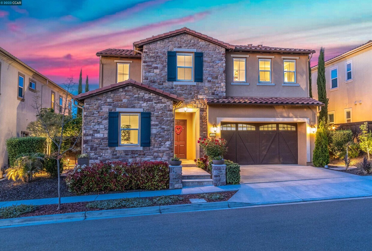
2004 Drysdale St
Danville, CA 94506
2 Weeks Ago
Favorites
2004 Drysdale St

Favorites
Check Back Soon for Upcoming Availability
| Beds | Baths | Average SF |
|---|---|---|
| 4 Bedrooms 4 Bedrooms 4 Br | 4.5 Baths 4.5 Baths 4.5 Ba | 3,662 SF |
About This Property
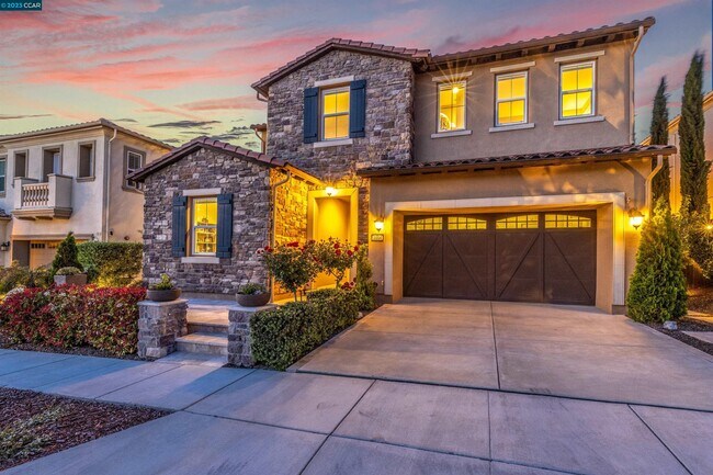
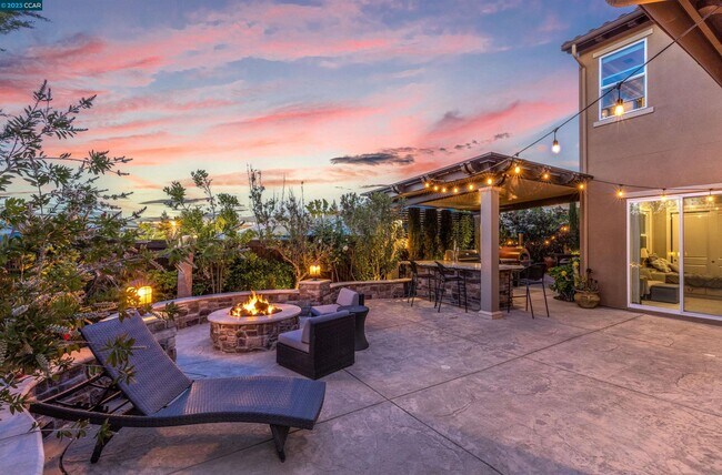
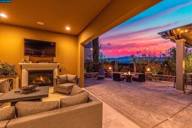
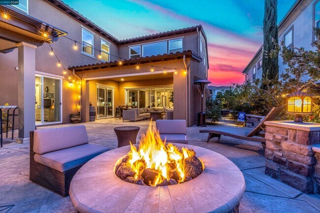
Upgraded finishes,features,attention to detail plus fabulous backyard sanctuary in Alamo Creek neighborhood,Danville’s Tassajara Valley. Celebrate indoor/outdoor living in California room w/frpl,near gas fire pit,or under custom-built pavilion w/outdoor built-in bbq,burners,sink,chiseled-edged leathered granite counter. Bocce ball court. Hot tub. Lush garden beds. 3662+/-SF. 4 bds. 4.5 bths. Main-level bdrm suite w/bkyd access. Main-level,front-facing office. Bonus/media room. Great room w/frpl,sliding wall of window to backyard patios. Chefs kitchen. Granite counters w/décor tile backsplash. Large island/breakfast br. Upgraded cabinetry,KitchenAid appliances. 550-bottle wine cellar. Polished porcelain tile & hardwood floors. 10-foot ceilings. Enhanced insulation for sound reduction. High ceilings. Custom wall paint colors. Crown molding. Recessed lighting. Primary suite w/Mt. Diablo views. En suite with dual vanities,soaking tub. Seamless glass-enclosed shower. Walk-in closet. 2-car garage. 2 EV outlets. Dual HVAC. Nest thermostats. Ring doorbell. LED lighting. Walk to community center,pool,fitness ctr,clubhouse. Near top-rated SRVUSD schls,Blackhawk Plaza,Tassajara Commons,downtown,freeways,soccer fields,equestrian centers,Livermore Valley Wine Country.
2004 Drysdale St is a house located in Contra Costa County and the 94506 ZIP Code. This area is served by the San Ramon Valley Unified attendance zone.
Location
Get Directions
Danville is an upscale suburban community located just south of Walnut Creek and about twenty miles east of Oakland. Residents enjoy an ideal location, surrounded by scenic rolling hills and lush greenery while still being within minutes of the Bay Area’s biggest cities. The thriving Downtown district along Hartz Boulevard is packed with terrific restaurants, specialty shops, and bars, as well as unique attractions like the Village Theatre and Art Gallery and the Danville Farmers’ Market. The surrounding landscape offers terrific opportunities to make the most of California’s natural beauty, with Las Trampas Regional Wilderness and the Diablo Foothills just outside of town providing great venues for hiking and camping.
Learn more about living in Danville
Education
| Colleges & Universities | Distance | ||
|---|---|---|---|
| Colleges & Universities | Distance | ||
| Drive: | 15 min | 7.2 mi | |
| Drive: | 25 min | 13.0 mi | |
| Drive: | 36 min | 20.1 mi | |
| Drive: | 38 min | 23.5 mi |
2004 Drysdale St is within 15 minutes or 7.2 miles from Diablo Valley Coll, San Ramon. It is also near Las Positas College and Saint Marys Coll. of Calif..
Schools


Public Elementary School
Grades K-5
497 Students
Nearby
Public Elementary School
Grades K-5
551 Students
Attendance Zone
Public Middle School
Grades 6-8
889 Students
Attendance Zone
Public High School
Grades 9-12
2,243 Students
Attendance Zone
Private Elementary & Middle School
Grades PK-8
Nearby
Private Elementary, Middle & High School
Grades K-12
673 Students
Nearby
School data provided by
 The GreatSchools Rating helps parents compare schools within a state based on a variety of school quality indicators and provides a helpful picture of how effectively each school serves all of its students. Ratings are on a scale of 1 (below average) to 10 (above average) and can include test scores, college readiness, academic progress, advanced courses, equity, discipline and attendance data. We also advise parents to visit schools, consider other information on school performance and programs, and consider family needs as part of the school selection process.
View GreatSchools Rating Methodology
Data provided by GreatSchools.org © 2025. All rights reserved.
View GreatSchools Rating Methodology
Data provided by GreatSchools.org © 2025. All rights reserved.
Transportation options available in Danville include Dublin Pleasanton Station, located 11.0 miles from 2004 Drysdale St. 2004 Drysdale St is near Metro Oakland International, located 29.8 miles or 43 minutes away, and San Francisco International, located 44.4 miles or 63 minutes away.
| Transit / Subway | Distance | ||
|---|---|---|---|
| Transit / Subway | Distance | ||
|
|
Drive: | 20 min | 11.0 mi |
|
|
Drive: | 19 min | 11.4 mi |
| Commuter Rail | Distance | ||
|---|---|---|---|
| Commuter Rail | Distance | ||
| Drive: | 25 min | 12.0 mi | |
| Drive: | 25 min | 12.1 mi | |
| Drive: | 25 min | 14.4 mi | |
| Drive: | 26 min | 14.6 mi | |
| Drive: | 28 min | 17.2 mi |
| Airports | Distance | ||
|---|---|---|---|
| Airports | Distance | ||
|
Metro Oakland International
|
Drive: | 43 min | 29.8 mi |
|
San Francisco International
|
Drive: | 63 min | 44.4 mi |
Time and distance from 2004 Drysdale St.
| Shopping Centers | Distance | ||
|---|---|---|---|
| Shopping Centers | Distance | ||
| Drive: | 7 min | 2.8 mi | |
| Drive: | 6 min | 2.8 mi | |
| Drive: | 7 min | 2.9 mi |
2004 Drysdale St has 3 shopping centers within 2.9 miles, which is about a 7-minute drive. The miles and minutes will be for the farthest away property.
| Parks and Recreation | Distance | ||
|---|---|---|---|
| Parks and Recreation | Distance | ||
|
Bishop Ranch Regional Preserve
|
Drive: | 18 min | 8.4 mi |
|
Dublin Hills Regional Parks
|
Drive: | 27 min | 11.8 mi |
|
Mount Diablo State Park
|
Drive: | 41 min | 13.5 mi |
|
Morgan Territory Regional Preserve
|
Drive: | 36 min | 16.0 mi |
|
Round Valley Regional Preserve
|
Drive: | 49 min | 30.0 mi |
2004 Drysdale St has 5 parks within 30.0 miles, including Bishop Ranch Regional Preserve, Morgan Territory Regional Preserve, and Mount Diablo State Park.
| Hospitals | Distance | ||
|---|---|---|---|
| Hospitals | Distance | ||
| Drive: | 14 min | 6.7 mi | |
| Drive: | 17 min | 9.2 mi |
2004 Drysdale St is 6.7 miles from San Ramon Regional Medical Center, and is convenient to other hospitals, including Stanford Health Care - ValleyCare.
You May Also Like
Similar Rentals Nearby


What Are Walk Score®, Transit Score®, and Bike Score® Ratings?
Walk Score® measures the walkability of any address. Transit Score® measures access to public transit. Bike Score® measures the bikeability of any address.
What is a Sound Score Rating?
A Sound Score Rating aggregates noise caused by vehicle traffic, airplane traffic and local sources
2004 Drysdale St
Danville, CA 94506