$1,100 Total Monthly Price
12 Month Lease

20 Litchfield Ave Unit A

,

Killingly, CT 06263

Share Listing
Favorites
20 Litchfield Ave Unit A
Share Listing
Favorites

Check Back Soon for Upcoming Availability

Beds Baths Average SF
3 Bedrooms 3 Bedrooms 3 Br 1 Bath 1 Bath 1 Ba 1,200 SF

Fees and Policies

The fees listed below are community-provided and may exclude utilities or add-ons. All payments are made directly to the property and are non-refundable unless otherwise specified.

  • Parking
  • Surface Lot
    --

Details

Utilities Included

  • Water
  • Trash Removal
  • Sewer

Property Information

  • 2 units

About This Property

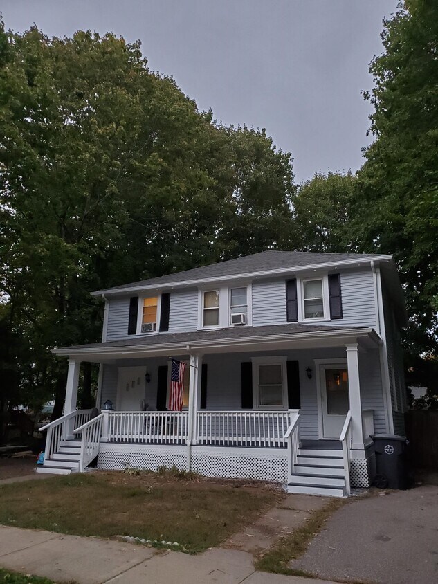
Newly renovated three bedroom in a quiet, family oriented neighborhood.

20 Litchfield Ave is an apartment community located in Windham County and the 06263 ZIP Code.

Apartment Features

  • Washer/Dryer Hookup
Location
20 Litchfield Ave, Killingly,
CT 06263
Get Directions
| Edit

Under 30 minutes

Commute Time is calculated at rush hour.
Amenities
  • Washer/Dryer Hookup
Expenses
Utilities Included
Water, Trash Removal, Sewer Included
Education
Colleges & Universities Distance
Drive: 36 min 22.8 mi
Drive: 37 min 23.2 mi
Drive: 39 min 23.5 mi
Drive: 43 min 28.7 mi
20 Litchfield Ave Unit A is within 36 minutes or 22.8 miles from University of Connecticut. It is also near Univ. of Connecticut, Depot and Eastern Connecticut.
Transportation

20 Litchfield Ave Unit A is near Rhode Island Tf Green International, located 35.0 miles or 51 minutes away, and Worcester Regional, located 35.6 miles or 52 minutes away.

Commuter Rail Distance
Drive: 43 min 30.5 mi
Drive: 48 min 32.2 mi
Drive: 49 min 34.1 mi
Drive: 53 min 35.3 mi
Drive: 58 min 43.2 mi
Airports Distance
Airports Distance
Rhode Island Tf Green International
Drive: 51 min 35.0 mi
Worcester Regional
Drive: 52 min 35.6 mi

Walkability Near 20 Litchfield Ave Killingly, CT 06263

Getting Around
Somewhat Walkable
Walkability
20 / 100
Minimal Public Transit
Transit
0 / 100
Exceptionally Drivable
Drivability
100 / 100
Somewhat Bikeable
Bikeability
20 / 100

Scores provided by

What do Walkability, Transit, Drivability, and Bikeability mean? Walkability measures the walking distance to day-to-day needs. Transit measures access to public transportation. Drivability measures congestion, parking availability, and access to major roads. Bikeability measures the suitability for cycling. How It Works
-
Soundscore
- / 100

Traffic

-

Airport

-

Businesses

-

Scores provided by

HowLoud What is a Sound Score Rating? A Sound Score Rating aggregates noise caused by vehicle traffic, airplane traffic and local sources. How It Works
Points of Interest

Time and distance from 20 Litchfield Ave Unit A.

Shopping Centers Distance
Drive: 7 min 2.4 mi
Drive: 6 min 2.6 mi
Drive: 7 min 2.7 mi
20 Litchfield Ave Unit A has 3 shopping centers within 2.7 miles, which is about a 7-minute drive. The miles and minutes will be for the farthest away property.
Parks and Recreation Distance
Connecticut Audubon Center at Pomfret
Drive: 9 min 4.4 mi
Mashamoquet Brook State Park
Drive: 13 min 5.3 mi
Quinebaug & Shetucket Rivers Valley National Heritage Corridor
Drive: 15 min 9.7 mi
Connecticut Audubon Center at Trail Wood
Drive: 21 min 11.3 mi
Pulaski Memorial State Park and Recreation Area
Drive: 24 min 14.5 mi
20 Litchfield Ave Unit A has 5 parks within 14.5 miles, including Connecticut Audubon Center at Pomfret, Mashamoquet Brook State Park, and Quinebaug & Shetucket Rivers Valley National Heritage Corridor.
Hospitals Distance
Hospitals Distance
Drive: 15 min 9.0 mi
20 Litchfield Ave Unit A is 9.0 miles and a 15 minute drive from Day Kimball Hospital.
Military Bases Distance
Drive: 61 min 44.1 mi
Drive: 57 min 44.1 mi
Drive: 58 min 45.1 mi
20 Litchfield Ave Unit A has 3 military bases within 45.1 miles, the nearest is Rhode Island National Gaurd which is 44.1 miles away and a 61 minute drive.

You May Also Like

Similar Rentals Nearby