
2 School St
2 School St
Weston, MA 02493
2 Weeks Ago
Favorites
2 School St

Favorites
Check Back Soon for Upcoming Availability
| Beds | Baths | Average SF |
|---|---|---|
| 2 Bedrooms 2 Bedrooms 2 Br | 1 Bath 1 Bath 1 Ba | 1,200 SF |
Fees and Policies
The fees below are based on community-supplied data and may exclude additional fees and utilities.
Pet policies are negotiable.
Details
Utilities Included
-
Water
About This Property
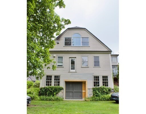
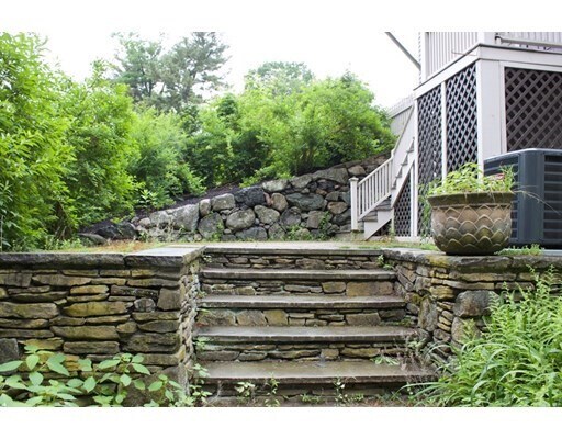
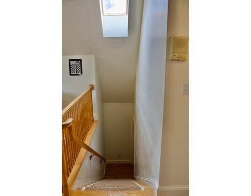
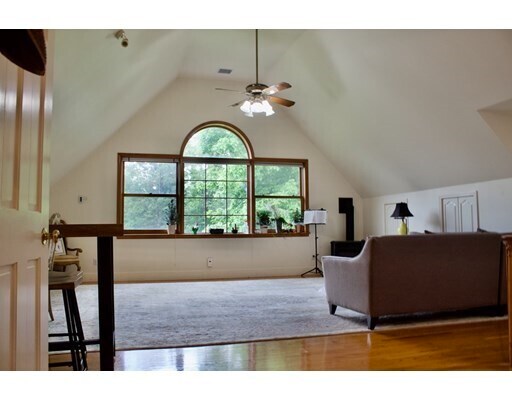
Available, July 1, this charming updated carriage house is in Weston Center. This sunny and spacious 2 bedroom has it all; Cathedral ceilings, skylights and hardwood floors along with a newer kitchen, marble bath, laundry in unit. The patio overlooks the beautiful grounds. Large sunny bonus room could be used as a large bedroom, home office, playroom or study. Great commuter location with easy access to major routes and close to shopping. Pets will be considered on case by case basis.
2 School St is a house located in Middlesex County and the 02493 ZIP Code. This area is served by the Weston attendance zone.
House Features
Air Conditioning
Dishwasher
Microwave
Refrigerator
- Air Conditioning
- Trash Compactor
- Fireplace
- Dishwasher
- Microwave
- Range
- Refrigerator
- Walking/Biking Trails
- Porch
Location
Get Directions
Just west of Boston and East of Worcester sits Metro West, a region that houses a group of towns and cities with significant historical backgrounds. A total of 19 municipalities make up the core of this community, but other municipalities are considered to be a part of the Interstate 495/Metro West Corridor.
Learn more about living in Metro WestBelow are rent ranges for similar nearby apartments
| Beds | Average Size | Lowest | Typical | Premium |
|---|---|---|---|---|
| Studio Studio Studio | 610-613 Sq Ft | $1,125 | $2,178 | $3,650 |
| 1 Bed 1 Bed 1 Bed | 881-883 Sq Ft | $850 | $2,794 | $9,940 |
| 2 Beds 2 Beds 2 Beds | 1281-1282 Sq Ft | $1,775 | $3,407 | $17,713 |
| 3 Beds 3 Beds 3 Beds | 1582-1586 Sq Ft | $1,000 | $4,543 | $21,898 |
| 4 Beds 4 Beds 4 Beds | 3631 Sq Ft | $1,075 | $6,454 | $30,000 |
Amenities
- Air Conditioning
- Trash Compactor
- Fireplace
- Dishwasher
- Microwave
- Range
- Refrigerator
- Porch
- Walking/Biking Trails
Expenses
Utilities Included
Water
Included
Education
| Colleges & Universities | Distance | ||
|---|---|---|---|
| Colleges & Universities | Distance | ||
| Drive: | 9 min | 3.8 mi | |
| Drive: | 10 min | 4.9 mi | |
| Drive: | 15 min | 6.9 mi | |
| Drive: | 15 min | 7.9 mi |
2 School St is within 9 minutes or 3.8 miles from Brandeis University. It is also near Bentley University and Babson College.
Schools


Public Elementary School
Grades 4-5
266 Students
Nearby
Public Elementary School
Grades PK-3
320 Students
Attendance Zone
Public Elementary School
Grades PK-3
331 Students
Attendance Zone
Public Middle School
Grades 6-8
444 Students
Attendance Zone
Public High School
Grades 9-12
639 Students
Attendance Zone
Private Elementary & Middle School
Grades PK-8
320 Students
Nearby
Private Elementary, Middle & High School
Grades 3-12
107 Students
Nearby
School data provided by
 The GreatSchools Rating helps parents compare schools within a state based on a variety of school quality indicators and provides a helpful picture of how effectively each school serves all of its students. Ratings are on a scale of 1 (below average) to 10 (above average) and can include test scores, college readiness, academic progress, advanced courses, equity, discipline and attendance data. We also advise parents to visit schools, consider other information on school performance and programs, and consider family needs as part of the school selection process.
View GreatSchools Rating Methodology
Data provided by GreatSchools.org © 2025. All rights reserved.
View GreatSchools Rating Methodology
Data provided by GreatSchools.org © 2025. All rights reserved.
Transportation options available in Weston include Riverside Station, located 5.1 miles from 2 School St. 2 School St is near General Edward Lawrence Logan International, located 18.7 miles or 29 minutes away, and Worcester Regional, located 36.1 miles or 57 minutes away.
| Transit / Subway | Distance | ||
|---|---|---|---|
| Transit / Subway | Distance | ||
|
|
Drive: | 9 min | 5.1 mi |
|
|
Drive: | 9 min | 5.4 mi |
|
|
Drive: | 11 min | 6.1 mi |
|
|
Drive: | 13 min | 7.7 mi |
|
|
Drive: | 13 min | 7.9 mi |
| Commuter Rail | Distance | ||
|---|---|---|---|
| Commuter Rail | Distance | ||
|
|
Drive: | 2 min | 1.2 mi |
| Drive: | 6 min | 2.3 mi | |
| Drive: | 7 min | 3.5 mi | |
|
|
Drive: | 7 min | 3.7 mi |
|
|
Drive: | 17 min | 10.1 mi |
| Airports | Distance | ||
|---|---|---|---|
| Airports | Distance | ||
|
General Edward Lawrence Logan International
|
Drive: | 29 min | 18.7 mi |
|
Worcester Regional
|
Drive: | 57 min | 36.1 mi |
Time and distance from 2 School St.
| Shopping Centers | Distance | ||
|---|---|---|---|
| Shopping Centers | Distance | ||
| Drive: | 5 min | 2.7 mi | |
| Drive: | 7 min | 2.8 mi | |
| Drive: | 7 min | 3.3 mi |
2 School St has 3 shopping centers within 3.3 miles, which is about a 7-minute drive. The miles and minutes will be for the farthest away property.
| Parks and Recreation | Distance | ||
|---|---|---|---|
| Parks and Recreation | Distance | ||
|
Land's Sake Farm
|
Walk: | 12 min | 0.6 mi |
|
Hamlen Woods
|
Drive: | 8 min | 4.1 mi |
|
Hazel Brook Conservation Area
|
Drive: | 9 min | 4.3 mi |
|
Mass Audubon's Drumlin Farm Wildlife Sanctuary
|
Drive: | 9 min | 4.5 mi |
|
Upper Mill Brook Conservation Area
|
Drive: | 8 min | 4.7 mi |
2 School St has 5 parks within 4.7 miles, including Land's Sake Farm, Hazel Brook Conservation Area, and Hamlen Woods.
| Hospitals | Distance | ||
|---|---|---|---|
| Hospitals | Distance | ||
| Drive: | 6 min | 3.1 mi | |
| Drive: | 8 min | 5.1 mi | |
| Drive: | 11 min | 6.0 mi |
2 School St has 3 hospitals within 6.0 miles, the nearest is Walden Behavioral Care which is 3.1 miles away and a 6 minute drive.
| Military Bases | Distance | ||
|---|---|---|---|
| Military Bases | Distance | ||
| Drive: | 14 min | 8.2 mi | |
| Drive: | 17 min | 8.7 mi |
2 School St is 8.2 miles from US Military Reservation, and is convenient to other military bases, including Hanscom Air Force Base.
You May Also Like
Similar Rentals Nearby
-
-

-

-

-

-
 $4,850Total Monthly Price12 Month Lease4 Beds, 2.5 Baths, 2,100 sq ftHouse for Rent
 -
 $8,800Total Monthly Price6 Month Lease4 Beds, 3.5 Baths, 3,878 sq ftHouse for Rent
 -
 $9,500Total Monthly Price12 Month Lease5 Beds, 3 Baths, 2,800 sq ftHouse for Rent
 -
 $6,500Total Monthly Price12 Month Lease5 Beds, 3.5 Baths, 2,498 sq ftHouse for Rent
 -
 $3,825Total Monthly Price12 Month Lease4 Beds, 2 Baths, 1,725 sq ftHouse for Rent
What Are Walk Score®, Transit Score®, and Bike Score® Ratings?
Walk Score® measures the walkability of any address. Transit Score® measures access to public transit. Bike Score® measures the bikeability of any address.
What is a Sound Score Rating?
A Sound Score Rating aggregates noise caused by vehicle traffic, airplane traffic and local sources

2 School St
Weston, MA 02493