


$7,500 / Month
19532 Natoma Oaks Ln
Los Altos Hills, CA 94022
Today
Favorites
-
Bedrooms
3
-
Bathrooms
3.5
-
Square Feet
2,500 sq ft
-
Available
Available Now
Highlights
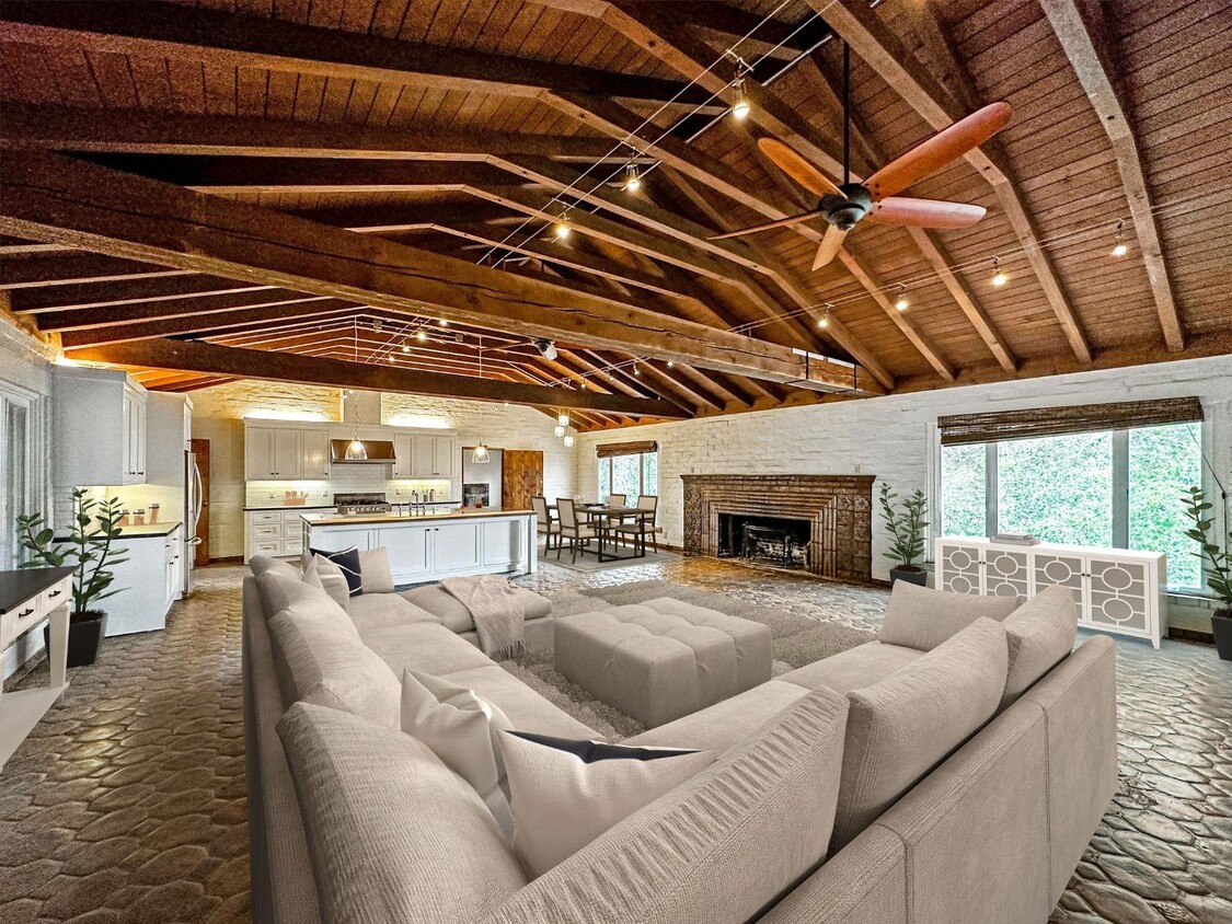
- Fireplace in Primary Bedroom
- Family Room with Fireplace
- 2 Fireplaces
- Wine Refrigerator
- 2 Car Detached Garage
- Open to Family Room
19532 Natoma Oaks Ln

Favorites
About This Home
Available Now
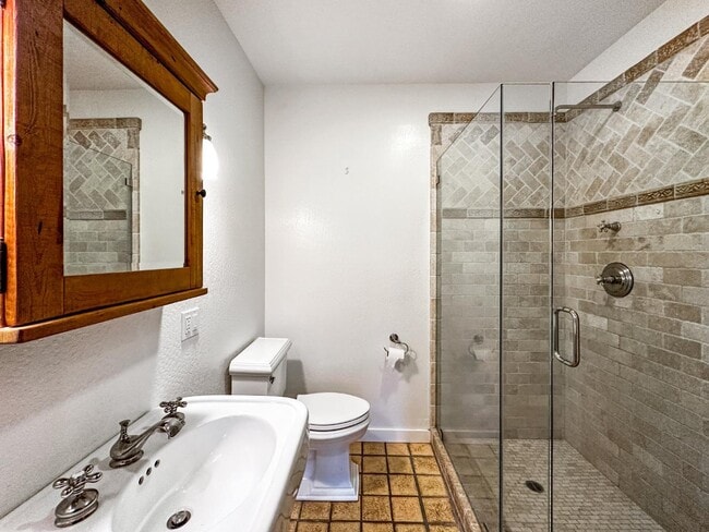
The spacious residence with a Spanish adobe style is nestled on a private cul-de sac. The approx. 2500 sf residence sits on a very private 3.0 acre parcel with panoramic Valley views. The house features a very spacious family area, with vaulted ceilings, an enormous fireplace, solid wood beams, and hand painted bathroom tiles. Direct access to renowned Los Altos Hills nature trail, Stegner pathway. Amazing wildlife scenery. Mature heritage oaks throughout the residence. Quick access to major employers, including Tesla (5 mins), VMware (5 mins), Uber (5mins), down Los Altons (8 mins), Stanford Research Park (10 mins), Stanford University (15 mins), downtown Woodside (15 mins). Part of renown Palo Alto School District (tenant to verify availability and schedule).
19532 Natoma Oaks Ln is a house located in Santa Clara County and the 94022 ZIP Code.
* Price shown is base rent and may not include non-optional fees and utilities.
Price, availability, fees, and any applicable rent special are subject to change without notice.
* Square footage definitions vary. Displayed square footage is approximate.
Home Details
Home Type
Single Family Detached Home
Bedrooms and Bathrooms
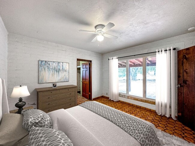
Fireplace in Primary Bedroom
3.5 Bathrooms
3 Bedrooms
Interior Spaces
Family Room with Fireplace
2 Fireplaces
Stone Flooring
Ceiling Fan
Dining Area
Wood Burning Fireplace
Gas Fireplace
2,500 Sq Ft Home
Kitchen
Wine Refrigerator
Open to Family Room
Eat-In Kitchen
Kitchen Island
Gas Cooktop
Gas Oven
Freezer
Microwave
Dishwasher
Laundry
Washer and Dryer
Listing and Financial Details
Security Deposit $10,000
Property Available on 8/1/25
12-Month Minimum Lease Term
Rent includes gardener
Lot Details
3.03 Acre Lot
Parking
2 Car Detached Garage
On-Street Parking
Community Details
Fees and Policies
The fees below are based on community-supplied data and may exclude additional fees and utilities.
Contact
- Listed by Curtis Lim | Compass
- Contact
Location
Get Directions
Amenities
- Fireplace
Home to some of Silicon Valley’s biggest movers and shakers, Los Altos is one of the most upscale towns in California and the nation. Tucked within rolling hills with gorgeous views of Silicon Valley, Los Altos Hills boast massive estates, elegant mansions, modern apartments, and posh condos available for rent. To maintain its rural feel, each new home is required to have at least one acre of land. Surrounded by golf clubs, nature preserves, parks, and more, Los Altos Hills is perfect for nature lovers. Apart from housing Foothill College, Los Altos Hills is entirely residential. Thankfully, residents don’t have to go far for shopping, dining, or entertainment since the town is convenient to several other cities such as Los Altos, Mountain View, Santa Clara, and San Francisco. Interstate 280 makes traveling throughout the Bay Area a breeze.
Learn more about living in Los Altos Hills
Education
| Colleges & Universities | Distance | ||
|---|---|---|---|
| Colleges & Universities | Distance | ||
| Drive: | 11 min | 2.9 mi | |
| Drive: | 16 min | 5.3 mi | |
| Drive: | 14 min | 5.4 mi | |
| Drive: | 21 min | 8.7 mi |
19532 Natoma Oaks Ln is within 11 minutes or 2.9 miles from Foothill Coll., Los Altos. It is also near Foothill College, Middlefield and Stanford University.
Transportation options available in Los Altos Hills include Mountain View Station, located 6.9 miles from 19532 Natoma Oaks Ln. 19532 Natoma Oaks Ln is near Norman Y Mineta San Jose International, located 16.2 miles or 31 minutes away, and San Francisco International, located 26.8 miles or 40 minutes away.
| Transit / Subway | Distance | ||
|---|---|---|---|
| Transit / Subway | Distance | ||
| Drive: | 17 min | 6.9 mi | |
|
|
Drive: | 17 min | 6.9 mi |
|
|
Drive: | 20 min | 8.2 mi |
| Drive: | 20 min | 8.7 mi | |
|
|
Drive: | 21 min | 8.8 mi |
| Commuter Rail | Distance | ||
|---|---|---|---|
| Commuter Rail | Distance | ||
| Drive: | 14 min | 5.3 mi | |
| Drive: | 13 min | 5.3 mi | |
| Drive: | 14 min | 5.6 mi | |
| Drive: | 19 min | 7.3 mi | |
| Drive: | 20 min | 7.5 mi |
| Airports | Distance | ||
|---|---|---|---|
| Airports | Distance | ||
|
Norman Y Mineta San Jose International
|
Drive: | 31 min | 16.2 mi |
|
San Francisco International
|
Drive: | 40 min | 26.8 mi |
Time and distance from 19532 Natoma Oaks Ln.
| Shopping Centers | Distance | ||
|---|---|---|---|
| Shopping Centers | Distance | ||
| Drive: | 12 min | 4.4 mi | |
| Drive: | 14 min | 4.9 mi | |
| Drive: | 16 min | 5.6 mi |
19532 Natoma Oaks Ln has 3 shopping centers within 5.6 miles, which is about a 16-minute drive. The miles and minutes will be for the farthest away property.
| Parks and Recreation | Distance | ||
|---|---|---|---|
| Parks and Recreation | Distance | ||
|
Esther Clark Nature Preserve
|
Drive: | 7 min | 2.7 mi |
|
Foothills Open Space Preserve
|
Drive: | 10 min | 3.2 mi |
|
Hidden Villa
|
Drive: | 11 min | 3.3 mi |
|
Byrne Preserve
|
Drive: | 10 min | 3.5 mi |
|
Pearson-Arastradero Regional Preserve
|
Drive: | 10 min | 3.6 mi |
19532 Natoma Oaks Ln has 5 parks within 3.6 miles, including Byrne Preserve, Pearson-Arastradero Regional Preserve, and Esther Clark Nature Preserve.
| Hospitals | Distance | ||
|---|---|---|---|
| Hospitals | Distance | ||
| Drive: | 16 min | 6.4 mi | |
| Drive: | 16 min | 7.1 mi | |
| Drive: | 18 min | 7.2 mi |
19532 Natoma Oaks Ln has 3 hospitals within 7.2 miles, the nearest is Lucile Salter Packard Children's Hospital at Stanford which is 6.4 miles away and a 16 minute drive.
| Military Bases | Distance | ||
|---|---|---|---|
| Military Bases | Distance | ||
| Drive: | 24 min | 9.1 mi |
19532 Natoma Oaks Ln is 9.1 miles and a 24 minute drive from Ames Research Center.
You May Also Like
Similar Rentals Nearby


What Are Walk Score®, Transit Score®, and Bike Score® Ratings?
Walk Score® measures the walkability of any address. Transit Score® measures access to public transit. Bike Score® measures the bikeability of any address.
What is a Sound Score Rating?
A Sound Score Rating aggregates noise caused by vehicle traffic, airplane traffic and local sources

19532 Natoma Oaks Ln
Los Altos Hills, CA 94022