
$2,300
/ Month
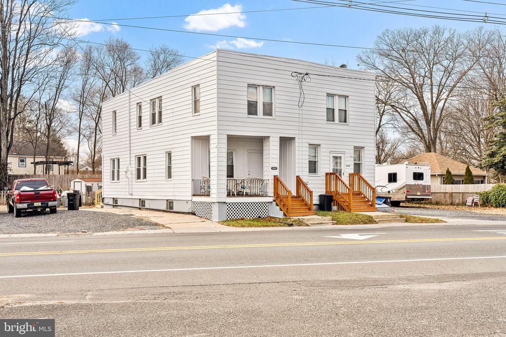
1945 Cooper St
Deptford, NJ 08096
Today
|
Edit
Favorites
609-694-6979
-
Bedrooms
3
-
Bathrooms
1
-
Square Feet
3,017 sq ft
-
Available
Available Jan 29
Highlight
- Basement
1945 Cooper St

Favorites
About This Home
Available Jan 29
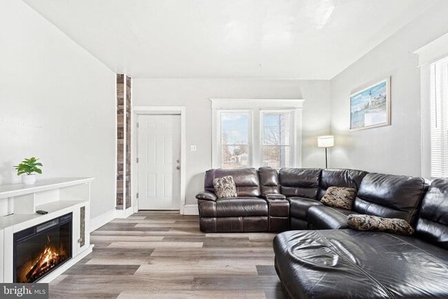
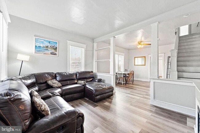
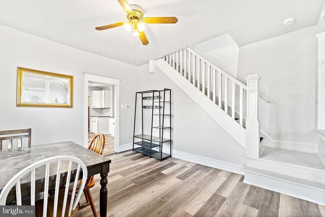
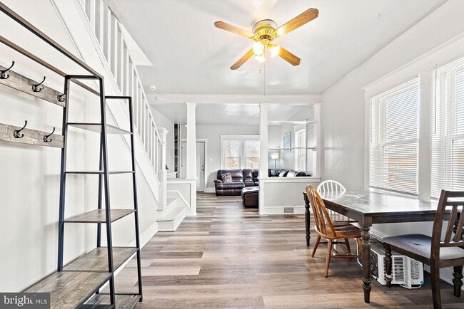
Move right in to this recently updated and freshly painted two-story, 3-bedroom, 1-bath unit offering comfort, space, and convenience. The home features a modern kitchen with new stainless steel appliances and generous living space across two levels. Washer and dryer are conveniently located in the unit, and a basement provides additional storage and utility space. The unit may be offered furnished or unfurnished, allowing flexibility based on the tenant’s preference. Enjoy a large backyard, ideal for relaxing or entertaining, along with a 4 car driveway, a rare and valuable feature for a rental. Ideally located just minutes from the mall, popular eateries, and major commuter routes including I-295, Routes 55 and 42, and the AC Expressway. Available for immediate occupancy, schedule your showing today.
1945 Cooper St is a house located in Gloucester County and the 08096 ZIP Code. This area is served by the Deptford Township Public attendance zone.
* Price shown is base rent. Excludes user-selected optional fees and variable or usage-based fees and required charges due at or prior to move-in or at move-out. Price, availability, fees, and any applicable rent special are subject to change without notice.
* Square footage definitions vary. Displayed square footage is approximate.
House Features
- Basement
Contact
- Listed by Keith Brian Fisher Jr. | Real Broker, LLC
- Phone Number
- Contact
-
Source
 Bright MLS, Inc.
Copyright © 2026 Bright MLS, Inc.
Location
Get Directions
Amenities
- Basement
Nestled amid suburban luxuries like peaceful neighborhoods and upscale shopping, Deptford offers residents a host of modern conveniences within close proximity to attractions in South Jersey and Philadelphia. A township in Gloucester County, Deptford contains the expansive Deptford Mall, boasting plenty of fine dining and shopping opportunities. The proximate Tall Pines State Reserve provides many options for outdoor recreation and nature appreciation in Deptford as well.
Deptford residents savor quick commute times to nearby Cherry Hill and Center City Philadelphia. Convenient access to numerous major highways such as the New Jersey Turnpike, I-295, Route 42, and Route 55 makes getting around from Deptford a breeze.
Learn more about living in Deptford
Education
| Colleges & Universities | Distance | ||
|---|---|---|---|
| Colleges & Universities | Distance | ||
| Drive: | 8 min | 4.4 mi | |
| Drive: | 9 min | 4.6 mi | |
| Drive: | 13 min | 7.8 mi | |
| Drive: | 15 min | 10.0 mi |
1945 Cooper St is within 8 minutes or 4.4 miles from Gloucester County College. It is also near Camden Co. Coll., Blackwood and Rowan University.
Schools


Public Elementary School
Grades 1-5
324 Students
Nearby
Public Elementary, Middle & High School
Grades 2-12
15 Students
Nearby
Charter Elementary School
Grades K-5
185 Students
Nearby
Public Elementary School
Grades PK-K
370 Students
Nearby
Public Middle School
Grades 6-8
432 Students
Nearby
Private Elementary & Middle School
Grades 1-7
9 Students
Nearby
Private Elementary, Middle & High School
Grades K-11
16 Students
Nearby
School data provided by
 The GreatSchools Rating helps parents compare schools within a state based on a variety of school quality indicators and provides a helpful picture of how effectively each school serves all of its students. Ratings are on a scale of 1 (below average) to 10 (above average) and can include test scores, college readiness, academic progress, advanced courses, equity, discipline and attendance data. We also advise parents to visit schools, consider other information on school performance and programs, and consider family needs as part of the school selection process.
View GreatSchools Rating Methodology
Data provided by GreatSchools.org © 2026. All rights reserved.
View GreatSchools Rating Methodology
Data provided by GreatSchools.org © 2026. All rights reserved.
Transportation options available in Deptford include Ashland, located 6.2 miles from 1945 Cooper St. 1945 Cooper St is near Philadelphia International, located 16.3 miles or 28 minutes away.
| Transit / Subway | Distance | ||
|---|---|---|---|
| Transit / Subway | Distance | ||
|
|
Drive: | 10 min | 6.2 mi |
|
|
Drive: | 11 min | 6.7 mi |
|
|
Drive: | 13 min | 7.5 mi |
|
|
Drive: | 12 min | 7.6 mi |
|
|
Drive: | 13 min | 7.9 mi |
| Commuter Rail | Distance | ||
|---|---|---|---|
| Commuter Rail | Distance | ||
|
|
Drive: | 12 min | 7.6 mi |
|
|
Drive: | 16 min | 9.8 mi |
|
|
Drive: | 30 min | 15.9 mi |
|
|
Drive: | 27 min | 16.1 mi |
|
|
Drive: | 28 min | 16.5 mi |
| Airports | Distance | ||
|---|---|---|---|
| Airports | Distance | ||
|
Philadelphia International
|
Drive: | 28 min | 16.3 mi |
Time and distance from 1945 Cooper St.
| Shopping Centers | Distance | ||
|---|---|---|---|
| Shopping Centers | Distance | ||
| Walk: | 6 min | 0.3 mi | |
| Walk: | 17 min | 0.9 mi | |
| Walk: | 17 min | 0.9 mi |
1945 Cooper St has 3 shopping centers within 0.9 mile, which is about a 17-minute walk. The miles and minutes will be for the farthest away property.
| Parks and Recreation | Distance | ||
|---|---|---|---|
| Parks and Recreation | Distance | ||
|
Downs Farms Trails
|
Drive: | 11 min | 6.8 mi |
|
Croft Farm Nature Trail
|
Drive: | 13 min | 8.1 mi |
|
Kresson Nature Trails
|
Drive: | 17 min | 9.7 mi |
|
Barclay Farmstead Nature Trail
|
Drive: | 17 min | 9.7 mi |
|
Franklin D. Roosevelt Park
|
Drive: | 19 min | 11.3 mi |
1945 Cooper St has 5 parks within 11.3 miles, including Downs Farms Trails, Croft Farm Nature Trail, and Barclay Farmstead Nature Trail.
| Hospitals | Distance | ||
|---|---|---|---|
| Hospitals | Distance | ||
| Drive: | 4 min | 2.4 mi | |
| Drive: | 9 min | 4.2 mi | |
| Drive: | 10 min | 5.9 mi |
1945 Cooper St has 3 hospitals within 5.9 miles, the nearest is Northbrook Behavioral Health Hospital which is 2.4 miles away and a 4 minute drive.
| Military Bases | Distance | ||
|---|---|---|---|
| Military Bases | Distance | ||
| Drive: | 18 min | 11.4 mi |
1945 Cooper St is 11.4 miles and a 18 minute drive from Philadelphia Naval Busi Center.
You May Also Like
How do I access Social Services in New Jersey?
Statewide service is free, confidential, multilingual and always open. Three easy ways to reach Social Services in NJ: Dial 2-1-1; text your zip code to 898-211; or chat at https://www.nj211.org
Similar Rentals Nearby


What Are Walk Score®, Transit Score®, and Bike Score® Ratings?
Walk Score® measures the walkability of any address. Transit Score® measures access to public transit. Bike Score® measures the bikeability of any address.
What is a Sound Score Rating?
A Sound Score Rating aggregates noise caused by vehicle traffic, airplane traffic and local sources

1945 Cooper St
Deptford, NJ 08096