
$5,399 / Month
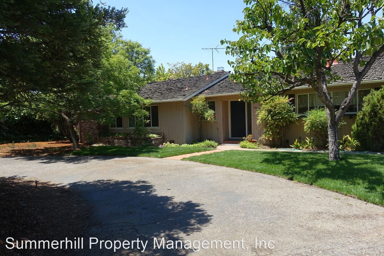
186 N Avalon Dr
Los Altos, CA 94022
2 Weeks Ago
Favorites
186 N Avalon Dr

Favorites
Check Back Soon for Upcoming Availability
| Beds | Baths | Average SF |
|---|---|---|
| 4 Bedrooms 4 Bedrooms 4 Br | 2.5 Baths 2.5 Baths 2.5 Ba | 1,737 SF |
About This Property
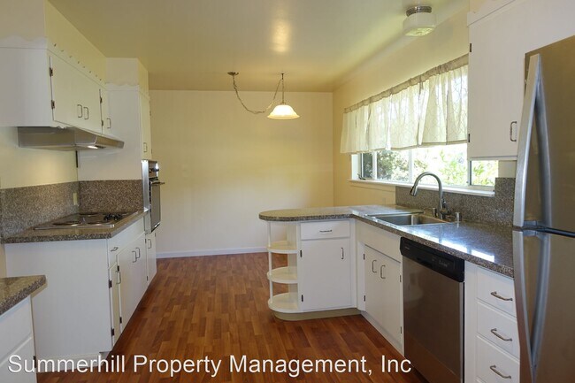
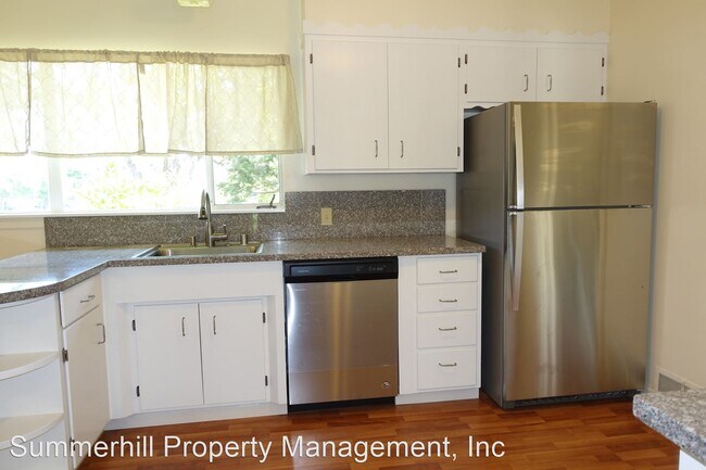
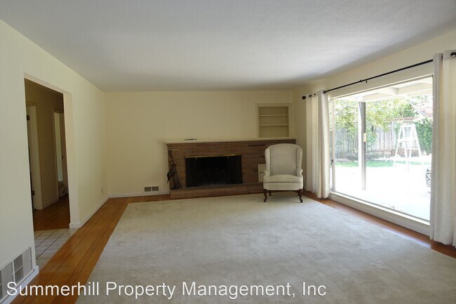
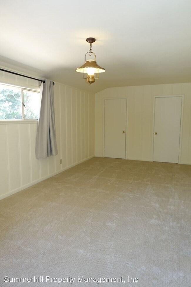
(650) 815-8588 - Spacious vintage ranch, HUGE yard, walk to Almond and LAHS, GREAT neighborhood! - Really wonderful Los Altos ranch house. BEST VALUE IN LOS ALTOS!! RENT discounted to $5399 through July 2021! Huge living room with a wall of windows open to the backyard. Features a wood burning fireplace for cozy winter evenings. Gleaming hardwood floors in most of the house. Nicely updated kitchen, with breakfast area. Three bedrooms to the left side of the house. Master with ensuite bath faces the lush backyard. On the other side of the house is a huge bedroom or family room, with plush carpeting. Laundry area with new washer and dryer. Two block walk to Almond Elementary, or two and a half blocks the other way to LAHS. Middle school is Egan, easy bike ride away. Tenant to verify availability at these schools. Owner pays gardening service. Full 2 car garage. Great storage space AND you can park your cars inside!! Please call Teri Berwick (BRE 01705674) at 650 815 8588 for an appointment to view. Professionally managed by Summerhill Property Management, Inc. (BRE 01523660) Please: no smoking, no pets. (RLNE4234806)
186 N Avalon Dr is a house located in Santa Clara County and the 94022 ZIP Code. This area is served by the Los Altos Elementary attendance zone.
Location
Get Directions
North Los Altos contains the city’s vibrant commercial centers. The many shops and eateries of Main Street are in the southern portion of North Los Altos, while the diverse restaurants and cafes of San Antonio Road are in the northern stretches near San Antonio Center.
Outside of these commercial areas, North Los Altos is predominantly residential, offering an array of apartments available for rent along tree-lined avenues. Many of the rentals in North Los Altos feature stunning mountain views, as well as close proximity to Mountain View, Foothill College, Stanford University, and Palo Alto. Getting around from North Los Altos is simple with access to El Camino Real, Interstate 280, and San Antonio Station.
Learn more about living in North Los AltosBelow are rent ranges for similar nearby apartments
| Beds | Average Size | Lowest | Typical | Premium |
|---|---|---|---|---|
| Studio Studio Studio | 475 Sq Ft | $2,150 | $3,265 | $5,347 |
| 1 Bed 1 Bed 1 Bed | 756-759 Sq Ft | $2,495 | $3,892 | $6,177 |
| 2 Beds 2 Beds 2 Beds | 1139-1146 Sq Ft | $3,295 | $5,110 | $7,749 |
| 3 Beds 3 Beds 3 Beds | 1408 Sq Ft | $4,441 | $4,962 | $5,750 |
| 4 Beds 4 Beds 4 Beds | 2599 Sq Ft | $6,790 | $12,222 | $18,875 |
Education
| Colleges & Universities | Distance | ||
|---|---|---|---|
| Colleges & Universities | Distance | ||
| Drive: | 7 min | 2.9 mi | |
| Drive: | 8 min | 3.2 mi | |
| Drive: | 13 min | 5.9 mi | |
| Drive: | 13 min | 7.1 mi |
186 N Avalon Dr is within 7 minutes or 2.9 miles from Foothill Coll., Los Altos. It is also near Foothill College, Middlefield and Stanford University.
Schools

Public Elementary School
Grades K-5
367 Students
Nearby
Public Elementary School
Grades K-6
353 Students
Attendance Zone
Public Middle School
Grades 7-8
497 Students
Attendance Zone
Public High School
Grades 9-12
2,141 Students
Attendance Zone
Private Elementary & Middle School
Grades PK-8
188 Students
Nearby
Private Elementary & Middle School
Grades 1-8
136 Students
Nearby
Private Elementary School
Grades K-6
80 Students
Nearby
Private High School
Grades 9-12
130 Students
Nearby
School data provided by
 The GreatSchools Rating helps parents compare schools within a state based on a variety of school quality indicators and provides a helpful picture of how effectively each school serves all of its students. Ratings are on a scale of 1 (below average) to 10 (above average) and can include test scores, college readiness, academic progress, advanced courses, equity, discipline and attendance data. We also advise parents to visit schools, consider other information on school performance and programs, and consider family needs as part of the school selection process.
View GreatSchools Rating Methodology
Data provided by GreatSchools.org © 2025. All rights reserved.
View GreatSchools Rating Methodology
Data provided by GreatSchools.org © 2025. All rights reserved.
Transportation options available in Los Altos include Mountain View Station, located 2.3 miles from 186 N Avalon Dr. 186 N Avalon Dr is near Norman Y Mineta San Jose International, located 11.5 miles or 19 minutes away, and San Francisco International, located 25.9 miles or 36 minutes away.
| Transit / Subway | Distance | ||
|---|---|---|---|
| Transit / Subway | Distance | ||
| Drive: | 6 min | 2.3 mi | |
|
|
Drive: | 6 min | 2.3 mi |
|
|
Drive: | 9 min | 3.7 mi |
|
|
Drive: | 9 min | 4.0 mi |
| Drive: | 10 min | 4.8 mi |
| Commuter Rail | Distance | ||
|---|---|---|---|
| Commuter Rail | Distance | ||
| Drive: | 6 min | 2.2 mi | |
| Drive: | 4 min | 2.3 mi | |
| Drive: | 7 min | 2.4 mi | |
| Drive: | 10 min | 4.5 mi | |
| Drive: | 11 min | 4.7 mi |
| Airports | Distance | ||
|---|---|---|---|
| Airports | Distance | ||
|
Norman Y Mineta San Jose International
|
Drive: | 19 min | 11.5 mi |
|
San Francisco International
|
Drive: | 36 min | 25.9 mi |
Time and distance from 186 N Avalon Dr.
| Shopping Centers | Distance | ||
|---|---|---|---|
| Shopping Centers | Distance | ||
| Walk: | 16 min | 0.8 mi | |
| Walk: | 16 min | 0.9 mi | |
| Drive: | 4 min | 1.9 mi |
186 N Avalon Dr has 3 shopping centers within 1.9 miles, which is about a 4-minute walk. The miles and minutes will be for the farthest away property.
| Parks and Recreation | Distance | ||
|---|---|---|---|
| Parks and Recreation | Distance | ||
|
Redwood Grove
|
Drive: | 5 min | 1.8 mi |
|
Foothill College Observatory
|
Drive: | 8 min | 3.1 mi |
|
Terman Park
|
Drive: | 7 min | 3.2 mi |
|
Esther Clark Nature Preserve
|
Drive: | 7 min | 3.3 mi |
|
J. Pearce Mitchell Park
|
Drive: | 10 min | 3.8 mi |
186 N Avalon Dr has 5 parks within 3.8 miles, including Redwood Grove, Terman Park, and Foothill College Observatory.
| Hospitals | Distance | ||
|---|---|---|---|
| Hospitals | Distance | ||
| Drive: | 6 min | 2.7 mi | |
| Drive: | 15 min | 6.3 mi | |
| Drive: | 14 min | 6.8 mi |
186 N Avalon Dr has 3 hospitals within 6.8 miles, the nearest is El Camino Hospital which is 2.7 miles away and a 6 minute drive.
| Military Bases | Distance | ||
|---|---|---|---|
| Military Bases | Distance | ||
| Drive: | 13 min | 4.6 mi |
186 N Avalon Dr is 4.6 miles and a 13 minute drive from Ames Research Center.
You May Also Like
Similar Rentals Nearby


What Are Walk Score®, Transit Score®, and Bike Score® Ratings?
Walk Score® measures the walkability of any address. Transit Score® measures access to public transit. Bike Score® measures the bikeability of any address.
What is a Sound Score Rating?
A Sound Score Rating aggregates noise caused by vehicle traffic, airplane traffic and local sources

186 N Avalon Dr
Los Altos, CA 94022