-
1831 Produce Lane

-
$2,295
/ Month
1831 Produce Ln
Johns Island, SC 29455
Favorites
1831 Produce Lane

Favorites
Check Back Soon for Upcoming Availability
| Beds | Baths | Average SF |
|---|---|---|
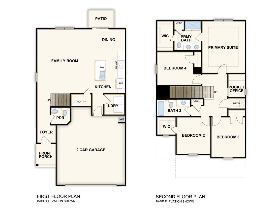
| 4 Bedrooms 4 Bedrooms 4 Br | 2.5 Baths 2.5 Baths 2.5 Ba | 1,888 SF |
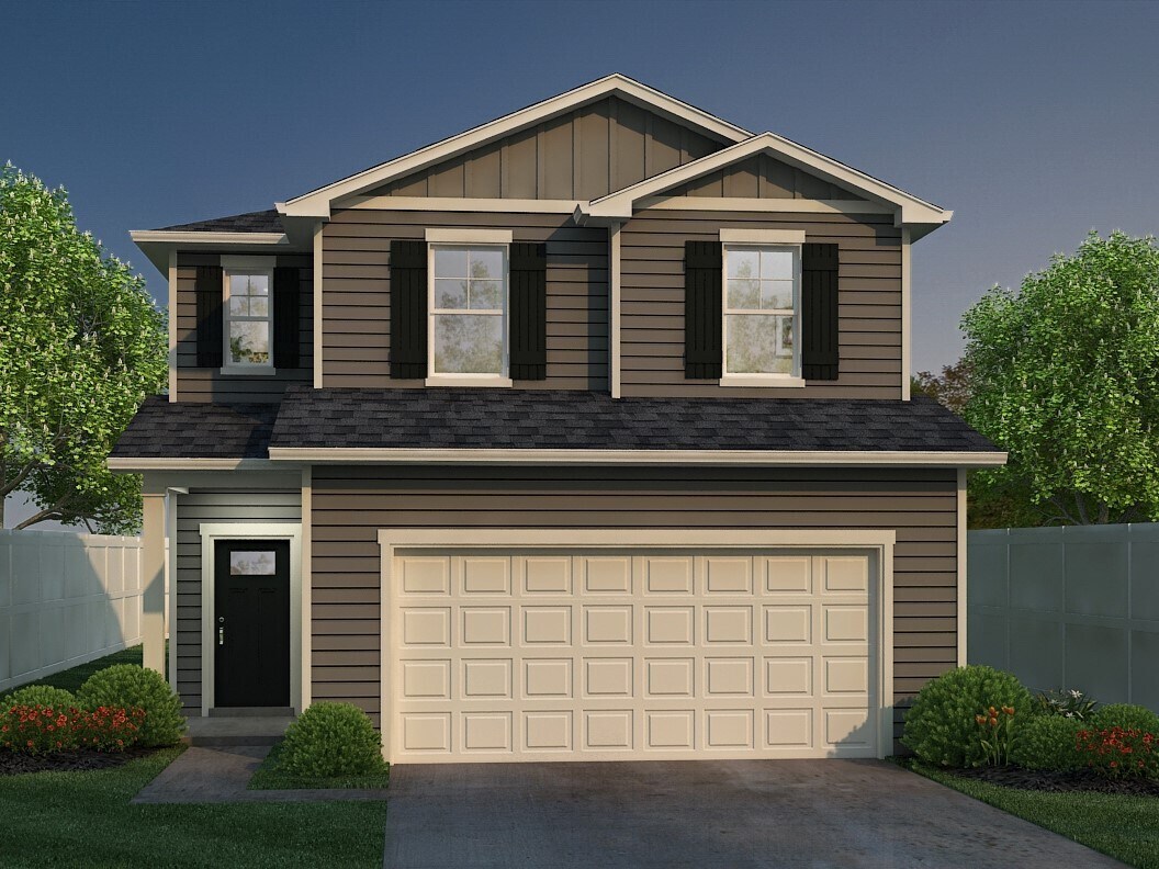
About This Property
We expect to make this brand new home available for showing and/or leasing soon. Home details on Landlord’s website are offered for illustrative purposes only. Actual home details may vary. Applicant should verify all information before lease execution. Please contact an American Homes 4 Rent leasing consultant for more information or take a self-guided tour of our currently available homes.
1831 Produce Lane is a house located in Charleston County and the 29455 ZIP Code. This area is served by the Charleston 01 School District attendance zone.
1831 Produce Ln,
Johns Island,
SC
29455
Johns Island sits on the South Carolina state line just south of the Charleston peninsula and is bordered to the north by the Stono and Wadmalaw Rivers. As the largest island in South Carolina, Johns Island encompasses an array of island living options and popular Lowcountry destinations. Upscale, modern apartment complexes and historic single-family homes can be found closer to the north of the island near Charleston.
The southern reaches of the island don’t lend themselves very well to large-scale residential development because of the surrounding marshland. However, the marshland is what makes Johns Island a hotspot for seafood and Lowcountry cuisine in general. Boating and fishing are wildly popular on the island, and many residents enjoy waterway access from their very own homes. The Angel Oak Tree is a popular tourist hotspot. The 60-foot-tall oak has a massive canopy that evokes the classic look of Lowcountry living.
Learn more about living in Johns IslandBelow are rent ranges for similar nearby apartments
| Beds | Average Size | Lowest | Typical | Premium |
|---|---|---|---|---|
| Studio Studio Studio | 553 Sq Ft | $1,623 | $1,689 | $1,887 |
| 1 Bed 1 Bed 1 Bed | 779-785 Sq Ft | $1,585 | $1,987 | $2,728 |
| 2 Beds 2 Beds 2 Beds | 1177-1184 Sq Ft | $2,055 | $2,491 | $3,334 |
| 3 Beds 3 Beds 3 Beds | 1507-1514 Sq Ft | $2,470 | $3,063 | $5,884 |
| 4 Beds 4 Beds 4 Beds | 2368 Sq Ft | $3,440 | $4,180 | $5,000 |
Education
| Colleges & Universities | Distance | ||
|---|---|---|---|
| Colleges & Universities | Distance | ||
| Drive: | 13 min | 6.8 mi | |
| Drive: | 15 min | 7.9 mi | |
| Drive: | 15 min | 8.0 mi | |
| Drive: | 16 min | 8.1 mi |
1831 Produce Lane is within 13 minutes or 6.8 miles from Medical Univ. of S.C.. It is also near The Citadel and Charleston School Of Law.
Schools


Public Elementary School
Grades PK-5
258 Students
Attendance Zone
Public Middle School
Grades 6-8
444 Students
Attendance Zone
Public High School
Grades 9-12
387 Students
Attendance Zone
Private Elementary, Middle & High School
Grades PK-12
283 Students
Nearby
School data provided by
 The GreatSchools Rating helps parents compare schools within a state based on a variety of school quality indicators and provides a helpful picture of how effectively each school serves all of its students. Ratings are on a scale of 1 (below average) to 10 (above average) and can include test scores, college readiness, academic progress, advanced courses, equity, discipline and attendance data. We also advise parents to visit schools, consider other information on school performance and programs, and consider family needs as part of the school selection process.
View GreatSchools Rating Methodology
Data provided by GreatSchools.org © 2026. All rights reserved.
View GreatSchools Rating Methodology
Data provided by GreatSchools.org © 2026. All rights reserved.
Walkability Near 1831 Produce Lane
Getting Around
 What do Walkability, Transit, Drivability, and Bikeability mean?
Walkability measures the walking distance to day-to-day needs.
Transit measures access to public transportation.
Drivability measures congestion, parking availability, and access to major roads.
Bikeability measures the suitability for cycling.
How It Works
What do Walkability, Transit, Drivability, and Bikeability mean?
Walkability measures the walking distance to day-to-day needs.
Transit measures access to public transportation.
Drivability measures congestion, parking availability, and access to major roads.
Bikeability measures the suitability for cycling.
How It Works
Somewhat Walkable
Walkability
30
/ 100
Minimal Public Transit
Transit
0
/ 100
Exceptionally Drivable
Drivability
90
/ 100
Somewhat Bikeable
Bikeability
20
/ 100
Scores provided by
Active
Soundscore™
77
/ 100
Traffic
ActiveAirport
CalmBusinesses
ActiveScores provided by
HowLoud What is a Sound Score Rating? A Sound Score Rating aggregates noise caused by vehicle traffic, airplane traffic and local sources. How It WorksYou May Also Like
Similar Rentals Nearby
-
-
 4 Beds$3,130Total Monthly PriceTotal Monthly Price NewPrices include all required monthly fees.House for Rent
 -
 4 Beds$2,260Total Monthly PriceTotal Monthly Price NewPrices include all required monthly fees.House for Rent
 -
 4 Beds$2,700Total Monthly PriceTotal Monthly Price NewPrices include all required monthly fees.House for Rent
 -
 5 Beds$2,690Total Monthly PriceTotal Monthly Price NewPrices include all required monthly fees.House for Rent
 -

-
 5 Beds$2,655Total Monthly PriceTotal Monthly Price NewPrices include all required monthly fees.House for Rent
 -
 5 Beds$2,765Total Monthly PriceTotal Monthly Price NewPrices include all required monthly fees.House for Rent
 -
 4 Beds$3,640Total Monthly PriceTotal Monthly Price NewPrices include all required monthly fees.House for Rent
 -
 4 Beds$2,695Total Monthly PriceTotal Monthly Price NewPrices include all required monthly fees.House for Rent

What Are Walk Score®, Transit Score®, and Bike Score® Ratings?
Walk Score® measures the walkability of any address. Transit Score® measures access to public transit. Bike Score® measures the bikeability of any address.
What is a Sound Score Rating?
A Sound Score Rating aggregates noise caused by vehicle traffic, airplane traffic and local sources.
1831 Produce Ln
Johns Island, SC 29455