

$4,095
/ Month
1730 Holt Ave
Los Altos, CA 94024
Today
Favorites
408-720-0920
-
Bedrooms
2
-
Bathrooms
1
-
Square Feet
1,000 sq ft
-
Available
Available Now
1730 Holt Ave

Favorites
About This Home
$3,900 deposit,
Available Now
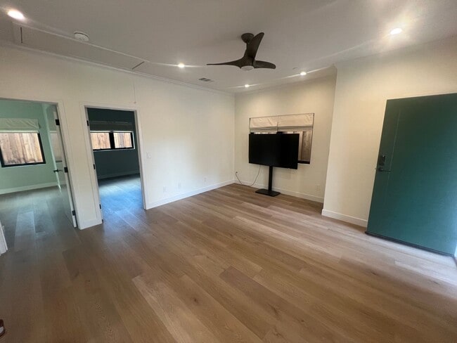
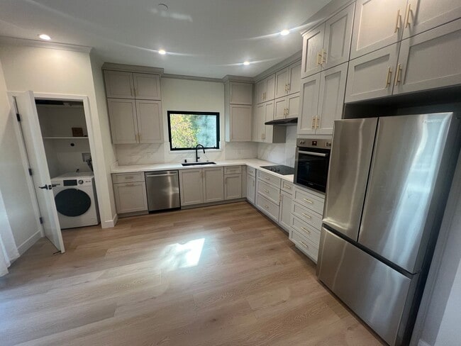
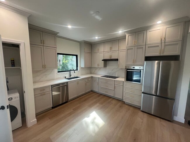
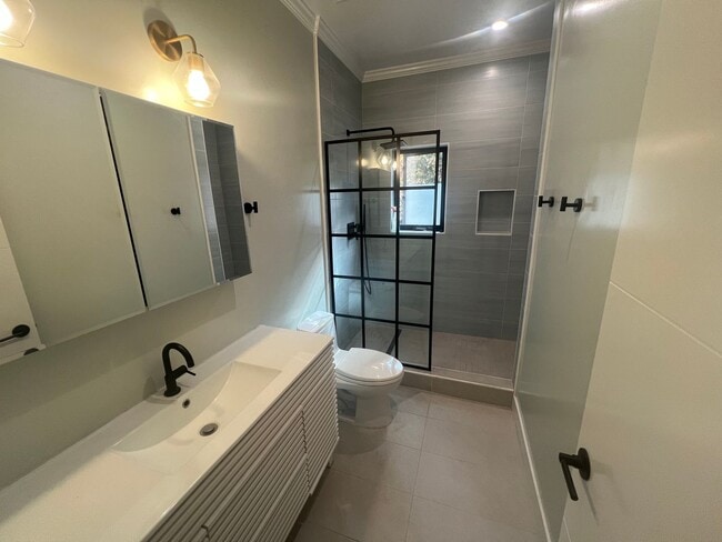
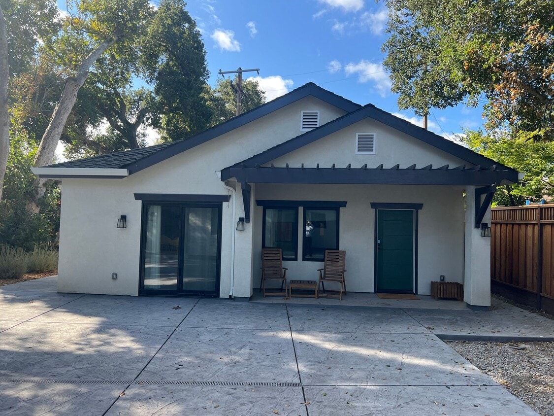
This serene Los Altos ADU cottage features 1000 square feet of living space. It features 2 bedrooms and 1 bathroom, kitchen, spacious living room, and private patio. This home is located in a beautiful and desirable neighborhood, only 11 minutes to downtown Los Altos. On a private court, located near Fallen Leaf Lane and Fremont Ave, this home is in close proximity to Grant Road, Foothill Expressway, and Highways 85/280. Parking -Street Laundry -Washer & Dryer Combo Included HVAC -Central Heating/cooling Utilities -Tenant pays 30% of Utilities Schools(Tenant to verify) -Montclaire Elementary School -Georgina P. Blach Middle School -Los Altos High School If this doesn’t quite meet your needs, check out our other available properties at or give us a call at .
Unique Features
- washer/dryer combo
- Central Heating & AC
- Tenant pays 30% of utilities.
1730 Holt Ave is a house located in Santa Clara County and the 94024 ZIP Code. This area is served by the Cupertino Union attendance zone.
* Price shown is base rent. Excludes user-selected optional fees and variable or usage-based fees and required charges due at or prior to move-in or at move-out. Price, availability, fees, and any applicable rent special are subject to change without notice.
* Square footage definitions vary. Displayed square footage is approximate.
House Features
- Dishwasher
Contact
- Listed by Altos Realty Advisors, Inc. | Altos Realty Advisors, Inc.
- Phone Number
- Contact
Location
Get Directions
Amenities
- Dishwasher
- washer/dryer combo
- Central Heating & AC
- Tenant pays 30% of utilities.
Los Altos likes to strike a balance between the urbanized atmosphere of the Bay Area and the more rural environment of the wide-open spaces bordering the city’s southwest side. While it is mainly a residential community, the downtown area surrounding Main Street is a walkable shopping and dining district with tree-lined streets and several public parks nearby. The crime rate is quite low and the local schools are among the highest-performing in the state. Palo Alto is right next door and San Jose just a few minutes down the road, giving Los Altos residents convenient access to Silicon Valley’s greatest amenities.
Learn more about living in Los Altos
Education
| Colleges & Universities | Distance | ||
|---|---|---|---|
| Colleges & Universities | Distance | ||
| Drive: | 8 min | 3.7 mi | |
| Drive: | 10 min | 5.4 mi | |
| Drive: | 13 min | 7.2 mi | |
| Drive: | 14 min | 8.6 mi |
1730 Holt Ave is within 8 minutes or 3.7 miles from De Anza College. It is also near Foothill Coll., Los Altos and Foothill College, Middlefield.
Schools


Public Elementary School
Grades K-5
367 Students
Nearby
Public Elementary School
Grades K-5
382 Students
Attendance Zone
Public Middle School
Grades 6-8
1,099 Students
Attendance Zone
Public High School
Grades 9-12
2,311 Students
Attendance Zone
Private Elementary, Middle & High School
Grades K-12
Nearby
Private Elementary & Middle School
Grades PK-8
247 Students
Nearby
School data provided by
 The GreatSchools Rating helps parents compare schools within a state based on a variety of school quality indicators and provides a helpful picture of how effectively each school serves all of its students. Ratings are on a scale of 1 (below average) to 10 (above average) and can include test scores, college readiness, academic progress, advanced courses, equity, discipline and attendance data. We also advise parents to visit schools, consider other information on school performance and programs, and consider family needs as part of the school selection process.
View GreatSchools Rating Methodology
Data provided by GreatSchools.org © 2025. All rights reserved.
View GreatSchools Rating Methodology
Data provided by GreatSchools.org © 2025. All rights reserved.
Transportation options available in Los Altos include Whisman Station, located 4.4 miles from 1730 Holt Ave. 1730 Holt Ave is near Norman Y Mineta San Jose International, located 8.3 miles or 19 minutes away, and San Francisco International, located 29.1 miles or 37 minutes away.
| Transit / Subway | Distance | ||
|---|---|---|---|
| Transit / Subway | Distance | ||
|
|
Drive: | 9 min | 4.4 mi |
| Drive: | 8 min | 4.4 mi | |
|
|
Drive: | 8 min | 4.4 mi |
|
|
Drive: | 8 min | 4.6 mi |
|
|
Drive: | 10 min | 6.0 mi |
| Commuter Rail | Distance | ||
|---|---|---|---|
| Commuter Rail | Distance | ||
| Drive: | 8 min | 4.2 mi | |
| Drive: | 8 min | 4.2 mi | |
| Drive: | 10 min | 4.4 mi | |
| Drive: | 13 min | 6.2 mi | |
| Drive: | 13 min | 6.4 mi |
| Airports | Distance | ||
|---|---|---|---|
| Airports | Distance | ||
|
Norman Y Mineta San Jose International
|
Drive: | 19 min | 8.3 mi |
|
San Francisco International
|
Drive: | 37 min | 29.1 mi |
Time and distance from 1730 Holt Ave.
| Shopping Centers | Distance | ||
|---|---|---|---|
| Shopping Centers | Distance | ||
| Walk: | 14 min | 0.8 mi | |
| Drive: | 4 min | 1.5 mi | |
| Drive: | 4 min | 1.6 mi |
1730 Holt Ave has 3 shopping centers within 1.6 miles, which is about a 4-minute walk. The miles and minutes will be for the farthest away property.
| Parks and Recreation | Distance | ||
|---|---|---|---|
| Parks and Recreation | Distance | ||
|
Deer Hollow Farm
|
Drive: | 7 min | 2.4 mi |
|
Rancho San Antonio County Park
|
Drive: | 8 min | 2.5 mi |
|
McClellan Ranch Park
|
Drive: | 7 min | 2.9 mi |
|
Fujitsu Planetarium
|
Drive: | 8 min | 3.7 mi |
|
Fremont Older Open Space Preserve
|
Drive: | 14 min | 5.6 mi |
1730 Holt Ave has 5 parks within 5.6 miles, including Deer Hollow Farm, Rancho San Antonio County Park, and McClellan Ranch Park.
| Hospitals | Distance | ||
|---|---|---|---|
| Hospitals | Distance | ||
| Drive: | 7 min | 2.5 mi | |
| Drive: | 10 min | 4.2 mi | |
| Drive: | 11 min | 4.6 mi |
1730 Holt Ave has 3 hospitals within 4.6 miles, the nearest is El Camino Hospital which is 2.5 miles away and a 7 minute drive.
| Military Bases | Distance | ||
|---|---|---|---|
| Military Bases | Distance | ||
| Drive: | 12 min | 6.1 mi |
1730 Holt Ave is 6.1 miles and a 12 minute drive from Ames Research Center.
You May Also Like
Similar Rentals Nearby


What Are Walk Score®, Transit Score®, and Bike Score® Ratings?
Walk Score® measures the walkability of any address. Transit Score® measures access to public transit. Bike Score® measures the bikeability of any address.
What is a Sound Score Rating?
A Sound Score Rating aggregates noise caused by vehicle traffic, airplane traffic and local sources
1730 Holt Ave
Los Altos, CA 94024