$1,300
Total Monthly Price
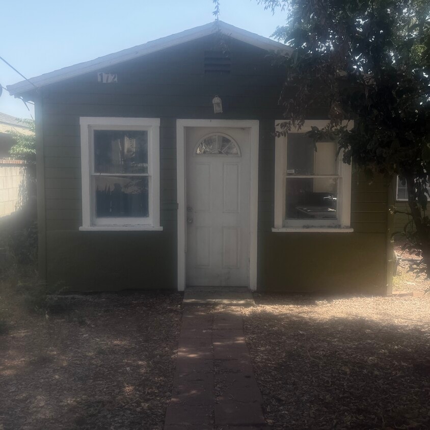
172 E Claremont St
Pasadena, CA 91103
Favorites
-
Bedrooms
1
-
Bathrooms
1
-
Square Feet
650 sq ft
-
Available
Available Now
Highlight
- Yard
172 E Claremont St

Favorites
About This Home
12 Month Lease,
$2,500 deposit,
Available Now
nice large fenced front yard, new wall air conditioner, new wall heater, owner provides complimentary laundry hookup, a kitchen gas stove, and a refrigerator. Pets welcome any
172 E Claremont St is a house located in Los Angeles County and the 91103 ZIP Code.
* Price shown is total price based on community-supplied monthly required fees. Excludes user-selected optional fees and variable or usage-based fees and required charges due at or prior to move-in or at move-out. Price, availability, fees, and any applicable rent special are subject to change without notice.
* Square footage definitions vary. Displayed square footage is approximate.
House Features
- Air Conditioning
- Kitchen
- Refrigerator
- Yard
Contact
- Contact
Location
Get Directions
Near the San Gabriel Mountains, where I-210 meets State Route 134 and becomes the Foothill Freeway, rests Pasadena’s Garfield Heights neighborhood. Primarily a residential area, Garfield Heights contains a number of markets, churches, and temples. Garfield Heights residents enjoy access to neighboring parks such as La Pintoresca Park and City of Pasadena Robinson Park.
There are a host of amenities located within close proximity to Garfield Heights. Among the many amenities are the Rose Bowl Stadium, Kidspace Children’s Museum, Norton Simon Museum, Brookside Golf and Country Club, Pasadena Convention Center, Paseo Colorado, and the California Institute of Technology.
Served by several Metro Local lines and Pasadena Transit routes, getting around Garfield Height is a breeze.
Learn more about living in Garfield Heights
Education
| Colleges & Universities | Distance | ||
|---|---|---|---|
| Colleges & Universities | Distance | ||
| Drive: | 4 min | 1.7 mi | |
| Drive: | 7 min | 3.2 mi | |
| Drive: | 8 min | 3.4 mi | |
| Drive: | 10 min | 3.6 mi |
172 E Claremont St is within 4 minutes or 1.7 miles from Fuller Theological Seminary. It is also near Pasadena City College and Art Center College of Design.
Transportation options available in Pasadena include Memorial Park Station, located 1.5 miles from 172 E Claremont St. 172 E Claremont St is near Bob Hope, located 17.5 miles or 24 minutes away, and Los Angeles International, located 26.0 miles or 42 minutes away.
| Transit / Subway | Distance | ||
|---|---|---|---|
| Transit / Subway | Distance | ||
|
|
Drive: | 4 min | 1.5 mi |
|
|
Drive: | 5 min | 1.9 mi |
|
|
Drive: | 4 min | 2.0 mi |
|
|
Drive: | 6 min | 2.7 mi |
|
|
Drive: | 5 min | 3.0 mi |
| Commuter Rail | Distance | ||
|---|---|---|---|
| Commuter Rail | Distance | ||
|
|
Drive: | 14 min | 10.0 mi |
|
|
Drive: | 19 min | 10.9 mi |
|
|
Drive: | 21 min | 11.0 mi |
|
|
Drive: | 21 min | 12.0 mi |
| Drive: | 23 min | 15.0 mi |
| Airports | Distance | ||
|---|---|---|---|
| Airports | Distance | ||
|
Bob Hope
|
Drive: | 24 min | 17.5 mi |
|
Los Angeles International
|
Drive: | 42 min | 26.0 mi |
Getting Around
 What do Walkability, Transit, Drivability, and Bikeability mean?
Walkability measures the walking distance to day-to-day needs.
Transit measures access to public transportation.
Drivability measures congestion, parking availability, and access to major roads.
Bikeability measures the suitability for cycling.
How It Works
What do Walkability, Transit, Drivability, and Bikeability mean?
Walkability measures the walking distance to day-to-day needs.
Transit measures access to public transportation.
Drivability measures congestion, parking availability, and access to major roads.
Bikeability measures the suitability for cycling.
How It Works
Moderately Walkable
Walkability
70
/ 100
Some Public Transit
Transit
40
/ 100
Very Drivable
Drivability
80
/ 100
Fairly Bikeable
Bikeability
50
/ 100
Scores provided by
Active
Soundscore™
75
/ 100
Traffic
ActiveAirport
CalmBusinesses
CalmScores provided by
HowLoud What is a Sound Score Rating? A Sound Score Rating aggregates noise caused by vehicle traffic, airplane traffic and local sources. How It WorksTime and distance from 172 E Claremont St.
| Shopping Centers | Distance | ||
|---|---|---|---|
| Shopping Centers | Distance | ||
| Walk: | 3 min | 0.2 mi | |
| Walk: | 18 min | 1.0 mi | |
| Walk: | 18 min | 1.0 mi |
172 E Claremont St has 3 shopping centers within 1.0 mile, which is about a 18-minute walk. The miles and minutes will be for the farthest away property.
| Parks and Recreation | Distance | ||
|---|---|---|---|
| Parks and Recreation | Distance | ||
|
Kidspace Children's Museum
|
Drive: | 5 min | 1.9 mi |
|
Jet Propulsion Laboratory
|
Drive: | 5 min | 2.4 mi |
|
Eaton Canyon Nature Center
|
Drive: | 8 min | 3.6 mi |
|
Huntington Botanical Gardens
|
Drive: | 11 min | 4.5 mi |
|
Descanso Gardens
|
Drive: | 10 min | 5.8 mi |
172 E Claremont St has 5 parks within 5.8 miles, including Kidspace Children's Museum, Jet Propulsion Laboratory, and Eaton Canyon Nature Center.
| Hospitals | Distance | ||
|---|---|---|---|
| Hospitals | Distance | ||
| Drive: | 6 min | 2.5 mi | |
| Drive: | 7 min | 3.0 mi | |
| Drive: | 9 min | 4.9 mi |
172 E Claremont St has 3 hospitals within 4.9 miles, the nearest is Huntington Memorial Hospital which is 2.5 miles away and a 6 minute drive.
| Military Bases | Distance | ||
|---|---|---|---|
| Military Bases | Distance | ||
| Drive: | 39 min | 27.6 mi | |
| Drive: | 49 min | 31.2 mi | |
| Drive: | 53 min | 38.4 mi |
172 E Claremont St has 3 military bases within 38.4 miles, the nearest is Los Angeles Air Force Base which is 27.6 miles away and a 39 minute drive.
Amenities
- Air Conditioning
- Kitchen
- Refrigerator
- Yard
172 E Claremont St Photos
What Are Walk Score®, Transit Score®, and Bike Score® Ratings?
Walk Score® measures the walkability of any address. Transit Score® measures access to public transit. Bike Score® measures the bikeability of any address.
What is a Sound Score Rating?
A Sound Score Rating aggregates noise caused by vehicle traffic, airplane traffic and local sources.

172 E Claremont St
Pasadena, CA 91103