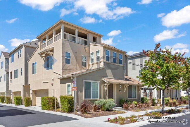
$2,700 / Month
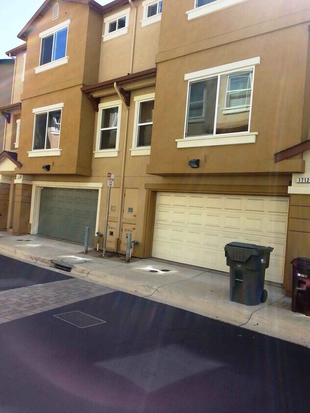
1710 Liberty Pointe Way
San Leandro, CA 94578
Today
Favorites
510-564-2821
-
Bedrooms
2
-
Bathrooms
2.5
-
Square Feet
1,277 sq ft
-
Available
Available Jun 15
1710 Liberty Pointe Way

Favorites
About This Home
$2,700 deposit,
Available Jun 15
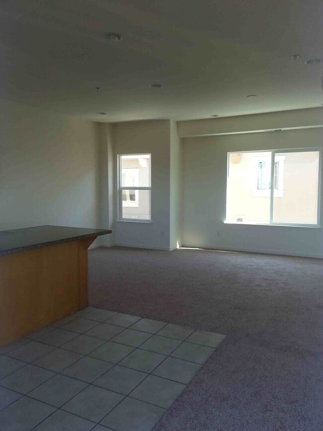
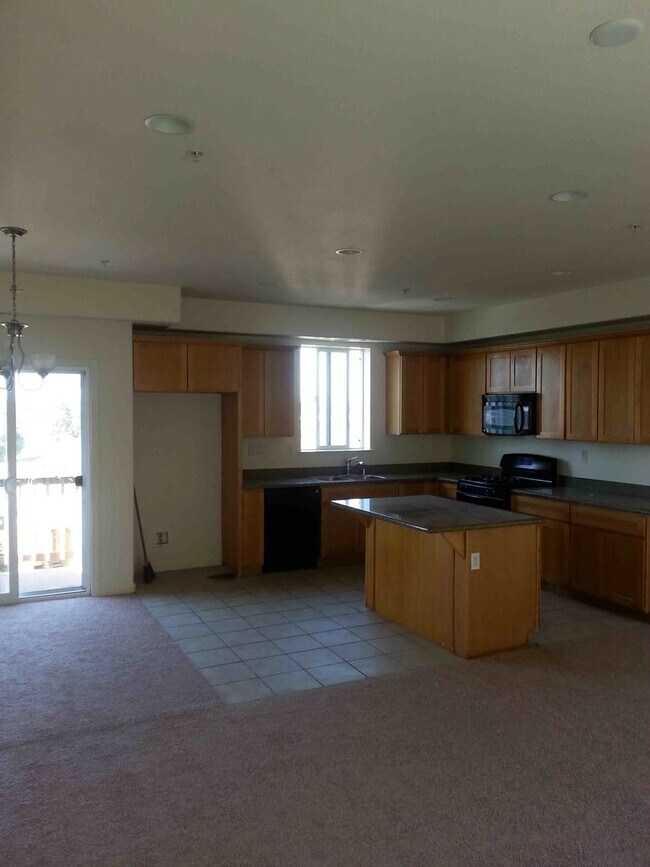
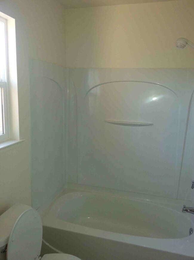
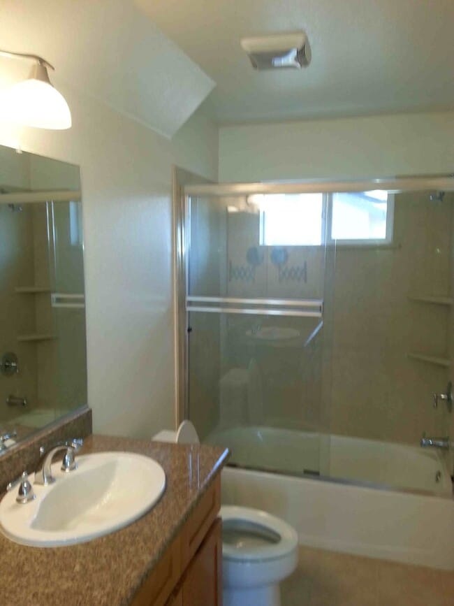
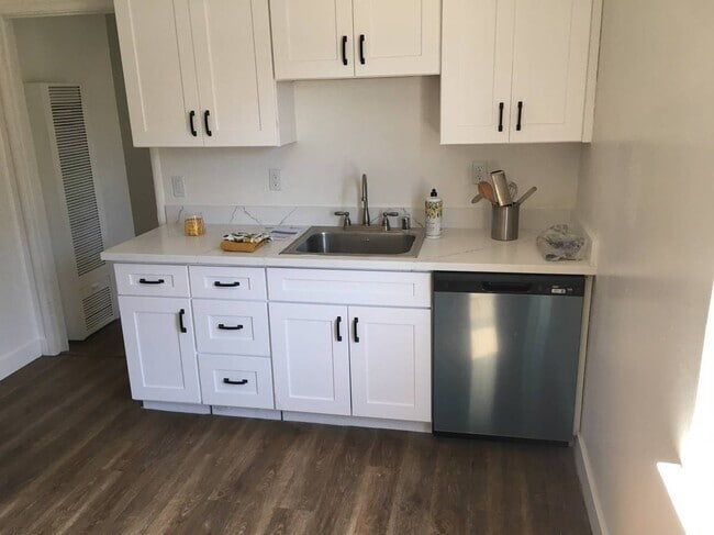
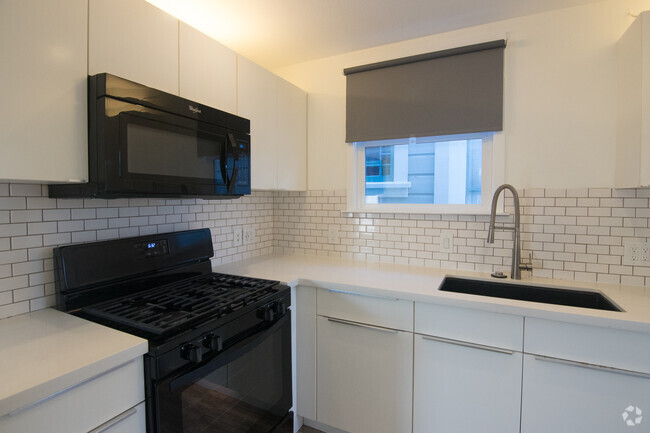
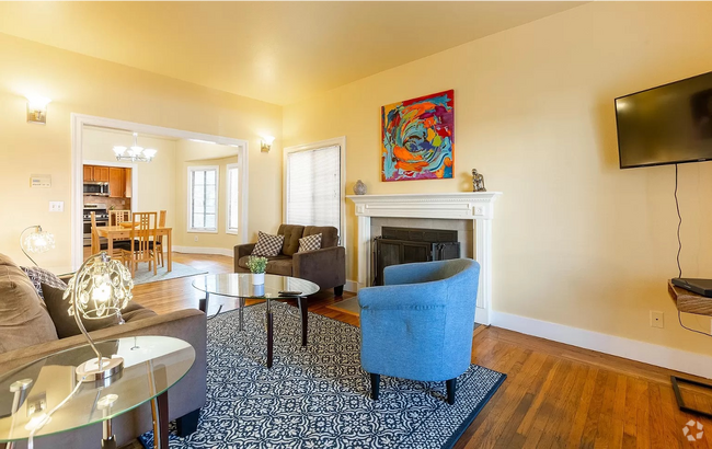
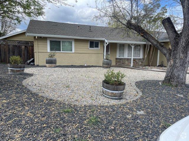
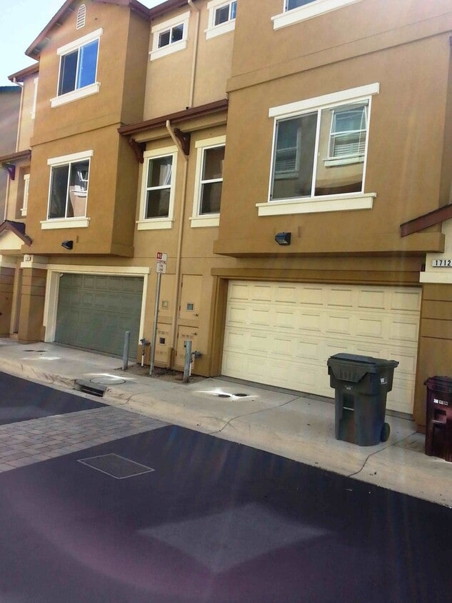
1710 LIBERTY POINTE WAY, SAN LEANDRO, CA 94578 * 2 Bedroom, 2 1/2 Baths * 2 Car Garage Attached * Gated Community * Alarm Available * Washer & Dryer Hookups * Gated Community * Rules And Regulations * Immediate Access to 580 Freeway * Grocery Store, Bayfair Mall & BART within 2 miles * Pets Negotiable This beautiful 2 bedroom townhouse is looking for a new tenant! It's located in a gated community, in the heart of San Leandro, within 2 miles of all the local stores, supermarket, malls and BART station. The property features a 2 car garage for you convenience and a beautiful partial bay view. Open house Information dates and times: For additional information, photos, online applications as well as information on our other available properties go to: For tenant qualifying requirements: We ask that you drive by any property you may have an interest in to acquaint yourself with the neighborhood and exterior of the home. **Please be advised that any dates published or given orally for a property's move in availability is subject to the existing tenant moving on the notified date. The date is also subject to time required to prepare the unit for occupancy, which involves owner approval and having an acceptable vendor available to complete the repairs. Once we have received a holding deposit, we will be able to provide a more accurate timeline for move-in. ** SLPM Property Management | Steve Francois - BRE license #02016432
1710 Liberty Pointe Way is a house located in Alameda County and the 94578 ZIP Code. This area is served by the San Lorenzo Unified attendance zone.
* Price shown is base rent and may not include non-optional fees and utilities.
Price, availability, fees, and any applicable rent special are subject to change without notice.
* Square footage definitions vary. Displayed square footage is approximate.
Contact
- Listed by SLPM Property Management | SLPM Property Management
- Phone Number
- Contact
Location
Get Directions
Ashland is a neighborhood conveniently located near the Interstate 238 and 580 junction and less than five miles east of the San Francisco Bay. The neighborhood is a residential area popular for commuters to Silicon Valley and other surrounding areas, so renters have several options to choose from. A variety of styles of apartments, condos, townhomes, and single-family houses are available in average Bay Area prices. Within town, residents can enjoy several restaurants and shopping destinations located along the neighborhood’s main roads. A few green spaces dot the area as well, but outdoor enthusiasts will appreciate the proximity of the Anthony Chabot Regional Park and the relaxing Bay Area beaches.
Learn more about living in Ashland
Education
| Colleges & Universities | Distance | ||
|---|---|---|---|
| Colleges & Universities | Distance | ||
| Drive: | 11 min | 4.7 mi | |
| Drive: | 13 min | 7.9 mi | |
| Drive: | 15 min | 9.0 mi | |
| Drive: | 36 min | 18.3 mi |
1710 Liberty Pointe Way is within 11 minutes or 4.7 miles from Cal State East Bay. It is also near Chabot College and Mills College.
Schools


Public Elementary School
Grades K-5
427 Students
Attendance Zone
Charter Elementary School
Grades K-5
483 Students
Nearby
Public Middle School
Grades 6-8
500 Students
Attendance Zone
Public High School
Grades 9-12
1,186 Students
Attendance Zone
Public High School
Grades 9-12
1,610 Students
Attendance Zone
Private Elementary School
Grades K
14 Students
Nearby
Private Elementary & Middle School
Grades PK-8
25 Students
Nearby
Private Elementary, Middle & High School
Grades 4-12
75 Students
Nearby
Private Elementary & Middle School
Grades K-8
214 Students
Nearby
School data provided by
 The GreatSchools Rating helps parents compare schools within a state based on a variety of school quality indicators and provides a helpful picture of how effectively each school serves all of its students. Ratings are on a scale of 1 (below average) to 10 (above average) and can include test scores, college readiness, academic progress, advanced courses, equity, discipline and attendance data. We also advise parents to visit schools, consider other information on school performance and programs, and consider family needs as part of the school selection process.
View GreatSchools Rating Methodology
View GreatSchools Rating Methodology
Transportation options available in San Leandro include Bay Fair Station, located 1.6 miles from 1710 Liberty Pointe Way. 1710 Liberty Pointe Way is near Metro Oakland International, located 9.0 miles or 14 minutes away, and San Francisco International, located 27.2 miles or 36 minutes away.
| Transit / Subway | Distance | ||
|---|---|---|---|
| Transit / Subway | Distance | ||
|
Bay Fair Station
|
Drive: | 5 min | 1.6 mi |
|
|
Drive: | 3 min | 2.5 mi |
|
|
Drive: | 6 min | 2.6 mi |
|
|
Drive: | 8 min | 4.1 mi |
|
|
Drive: | 14 min | 5.8 mi |
| Commuter Rail | Distance | ||
|---|---|---|---|
| Commuter Rail | Distance | ||
|
|
Drive: | 8 min | 3.3 mi |
| Drive: | 8 min | 3.3 mi | |
|
|
Drive: | 17 min | 13.1 mi |
| Drive: | 22 min | 14.4 mi | |
| Drive: | 21 min | 15.9 mi |
| Airports | Distance | ||
|---|---|---|---|
| Airports | Distance | ||
|
Metro Oakland International
|
Drive: | 14 min | 9.0 mi |
|
San Francisco International
|
Drive: | 36 min | 27.2 mi |
Time and distance from 1710 Liberty Pointe Way.
| Shopping Centers | Distance | ||
|---|---|---|---|
| Shopping Centers | Distance | ||
| Walk: | 17 min | 0.9 mi | |
| Drive: | 3 min | 1.4 mi | |
| Drive: | 5 min | 1.6 mi |
1710 Liberty Pointe Way has 3 shopping centers within 1.6 miles, which is about a 5-minute walk. The miles and minutes will be for the farthest away property.
| Parks and Recreation | Distance | ||
|---|---|---|---|
| Parks and Recreation | Distance | ||
|
Lake Chabot Regional Park
|
Drive: | 6 min | 2.7 mi |
|
Don Castro Regional Recreation Area
|
Drive: | 5 min | 3.6 mi |
|
Sulphur Creek Nature Center
|
Drive: | 10 min | 5.0 mi |
|
Cull Canyon Regional Recreation Area
|
Drive: | 10 min | 5.1 mi |
|
Hayward Regional Shoreline
|
Drive: | 13 min | 5.6 mi |
1710 Liberty Pointe Way has 5 parks within 5.6 miles, including Lake Chabot Regional Park, Don Castro Regional Recreation Area, and Cull Canyon Regional Recreation Area.
| Hospitals | Distance | ||
|---|---|---|---|
| Hospitals | Distance | ||
| Drive: | 3 min | 1.5 mi | |
| Drive: | 8 min | 5.3 mi | |
| Drive: | 12 min | 7.6 mi |
1710 Liberty Pointe Way has 3 hospitals within 7.6 miles, the nearest is Willow Rock Center which is 1.5 miles away and a 3 minute drive.
| Military Bases | Distance | ||
|---|---|---|---|
| Military Bases | Distance | ||
| Drive: | 25 min | 16.5 mi |
1710 Liberty Pointe Way is 16.5 miles and a 25 minute drive from Alameda/US Naval Air Station Alameda.
You May Also Like
Similar Rentals Nearby

What Are Walk Score®, Transit Score®, and Bike Score® Ratings?
Walk Score® measures the walkability of any address. Transit Score® measures access to public transit. Bike Score® measures the bikeability of any address.
What is a Sound Score Rating?
A Sound Score Rating aggregates noise caused by vehicle traffic, airplane traffic and local sources
1710 Liberty Pointe Way
San Leandro, CA 94578