
$20,000 / Month
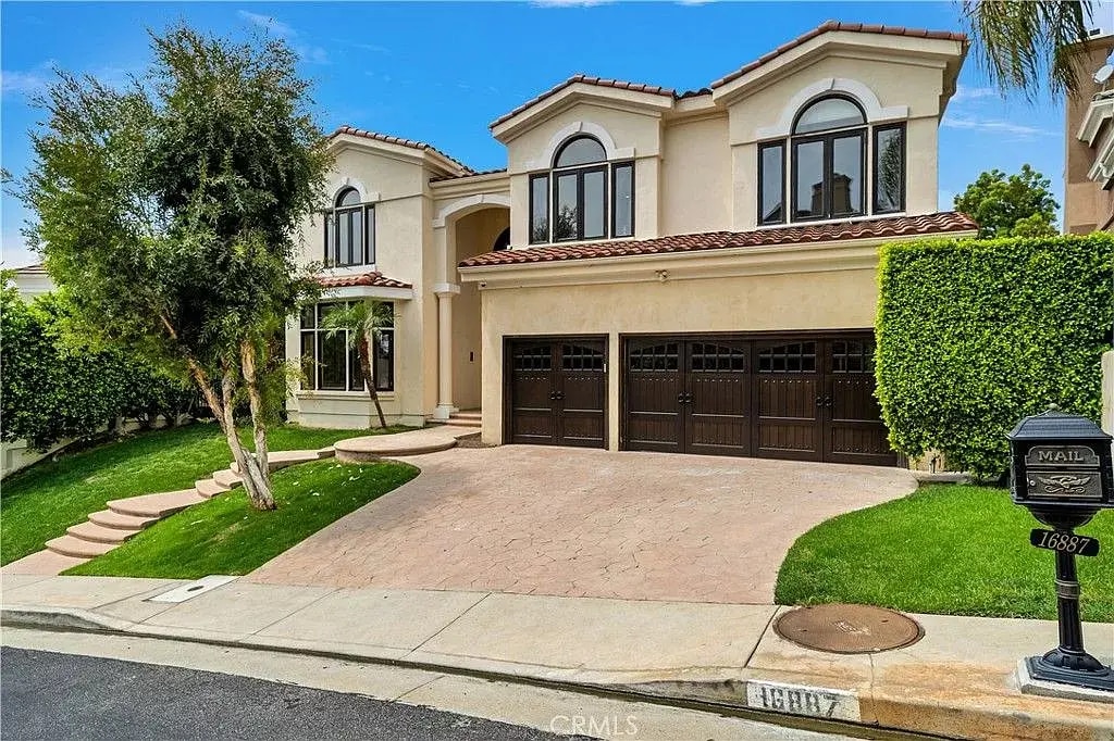
16887 Calle de Sarah
Pacific Palisades, CA 90272
2 Weeks Ago
Favorites
16887 Calle de Sarah

Favorites
Check Back Soon for Upcoming Availability
| Beds | Baths | Average SF |
|---|---|---|
| 6 Bedrooms 6 Bedrooms 6 Br | 6.5 Baths 6.5 Baths 6.5 Ba | 5,898 SF |
Fees and Policies
The fees below are based on community-supplied data and may exclude additional fees and utilities.
- Parking
-
Garage--
About This Property
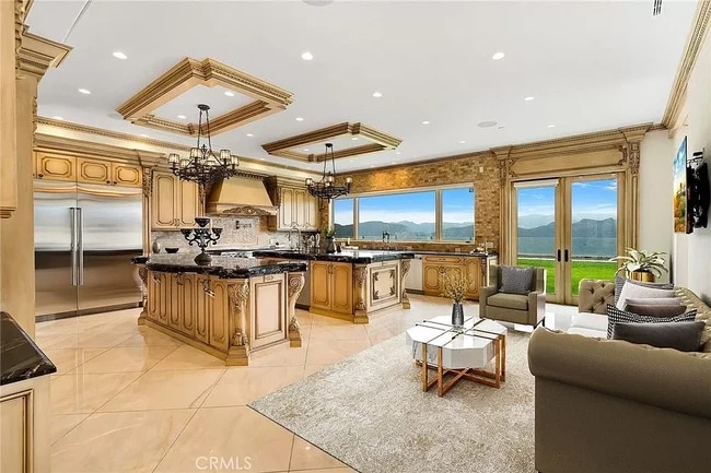
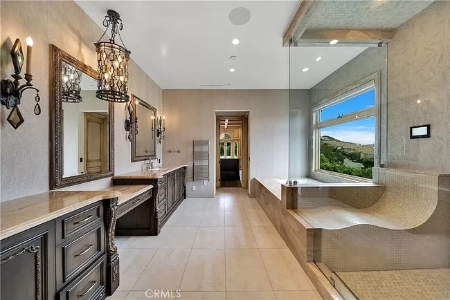
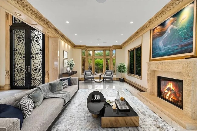
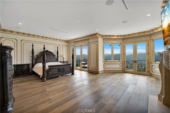
Set in the guard-gated neighborhood of The Enclave, this view estate enjoys unparalleled views from all rooms. A living room with a fireplace welcomes guests. The dining room flows to the kitchen with 2 islands, as well as the family room with a walk-in bar and fireplace. Upstairs, the sumptuous master suite features large walk-in closets, a spa-like bath with oversized shower, spa tub, and expansive deck. 5 ensuite bedrooms and a laundry room finish the 2nd level. The offering is completed by a finished 3-car garage and private walking trail through a fruit orchard with unique access to the exclusive Summit Club featuring a gym, pool, spa, tennis and basketball courts, and playground.
16887 Calle de Sarah is a house located in Los Angeles County and the 90272 ZIP Code.
House Features
Washer/Dryer Hookup
High Speed Internet Access
Walk-In Closets
Wi-Fi
- High Speed Internet Access
- Wi-Fi
- Washer/Dryer Hookup
- Heating
- Cable Ready
- Satellite TV
- Security System
- Storage Space
- Tub/Shower
- Fireplace
- Handrails
- Surround Sound
- Intercom
- Sprinkler System
- Kitchen
- Dining Room
- Family Room
- Walk-In Closets
- Laundry Facilities
- Spa
- Pool
- Playground
- Gated
- Deck
Location
Get Directions
From mountain hikes to beach volleyball, everything you've heard about Pacific Palisades is true -- it is gorgeous, filled with outdoor adventures, and is home to some of California's most beautiful stretches of beach. Situated directly north of Santa Monica and just 16 miles west of Downtown Los Angeles, it's easy to see why this is the playground for movie stars and celebrities. Cruise along the Pacific Coast Highway to Sunset Beach, play volleyball at Will Rogers State Beach, or go bicycling along the ocean at Marvin Braude Bike Trail.
On days you'd rather be hiking than surfing, Temescal Canyon State Park, Rivas Canyon Park, and Will Rogers State Historic Park are all on the east side of Pacific Palisades. Palisades Park features a rec center, a playground, ball fields, and picnic areas. Topanga State Park features 36 miles of hiking trails. While Pacific Palisades is primarily a residential area, Sunset Boulevard is home to several shops, restaurants, and other businesses.
Learn more about living in Pacific Palisades
Amenities
- High Speed Internet Access
- Wi-Fi
- Washer/Dryer Hookup
- Heating
- Cable Ready
- Satellite TV
- Security System
- Storage Space
- Tub/Shower
- Fireplace
- Handrails
- Surround Sound
- Intercom
- Sprinkler System
- Kitchen
- Dining Room
- Family Room
- Walk-In Closets
- Laundry Facilities
- Gated
- Deck
- Spa
- Pool
- Playground
Education
| Colleges & Universities | Distance | ||
|---|---|---|---|
| Colleges & Universities | Distance | ||
| Drive: | 18 min | 8.1 mi | |
| Drive: | 20 min | 8.8 mi | |
| Drive: | 22 min | 10.6 mi | |
| Drive: | 34 min | 13.1 mi |
16887 Calle de Sarah is within 18 minutes or 8.1 miles from Santa Monica Coll., Emeritus. It is also near Santa Monica College, Madison and Santa Monica Coll., Academy.
Transportation options available in Pacific Palisades include Downtown Santa Monica, located 8.6 miles from 16887 Calle de Sarah. 16887 Calle de Sarah is near Los Angeles International, located 17.1 miles or 34 minutes away, and Bob Hope, located 30.9 miles or 49 minutes away.
| Transit / Subway | Distance | ||
|---|---|---|---|
| Transit / Subway | Distance | ||
|
|
Drive: | 20 min | 8.6 mi |
|
|
Drive: | 21 min | 9.9 mi |
|
|
Drive: | 22 min | 10.6 mi |
|
|
Drive: | 22 min | 11.5 mi |
| Drive: | 24 min | 12.4 mi |
| Commuter Rail | Distance | ||
|---|---|---|---|
| Commuter Rail | Distance | ||
|
|
Drive: | 50 min | 24.3 mi |
|
|
Drive: | 43 min | 27.3 mi |
|
|
Drive: | 49 min | 30.9 mi |
|
|
Drive: | 49 min | 31.0 mi |
|
|
Drive: | 50 min | 31.0 mi |
| Airports | Distance | ||
|---|---|---|---|
| Airports | Distance | ||
|
Los Angeles International
|
Drive: | 34 min | 17.1 mi |
|
Bob Hope
|
Drive: | 49 min | 30.9 mi |
Time and distance from 16887 Calle de Sarah.
| Shopping Centers | Distance | ||
|---|---|---|---|
| Shopping Centers | Distance | ||
| Drive: | 9 min | 3.6 mi | |
| Drive: | 20 min | 8.9 mi | |
| Drive: | 20 min | 9.0 mi |
16887 Calle de Sarah has 3 shopping centers within 9.0 miles, which is about a 20-minute drive. The miles and minutes will be for the farthest away property.
| Parks and Recreation | Distance | ||
|---|---|---|---|
| Parks and Recreation | Distance | ||
|
Topanga State Park
|
Walk: | 35 min | 1.9 mi |
|
Temescal Gateway Park
|
Drive: | 13 min | 5.6 mi |
|
Will Rogers State Beach
|
Drive: | 13 min | 5.8 mi |
|
Will Rogers State Historic Park
|
Drive: | 21 min | 7.8 mi |
|
Santa Monica State Beach
|
Drive: | 17 min | 7.9 mi |
16887 Calle de Sarah has 5 parks within 7.9 miles, including Topanga State Park, Temescal Gateway Park, and Will Rogers State Beach.
| Hospitals | Distance | ||
|---|---|---|---|
| Hospitals | Distance | ||
| Drive: | 21 min | 9.0 mi | |
| Drive: | 22 min | 10.5 mi | |
| Drive: | 42 min | 26.6 mi |
16887 Calle de Sarah has 3 hospitals within 26.6 miles, the nearest is Santa Monica - UCLA Medical Center & Orthopaedic Hospital which is 9.0 miles away and a 21 minute drive.
| Military Bases | Distance | ||
|---|---|---|---|
| Military Bases | Distance | ||
| Drive: | 35 min | 22.5 mi |
16887 Calle de Sarah is 22.5 miles and a 35 minute drive from Los Angeles Air Force Base.
You May Also Like
Similar Rentals Nearby


What Are Walk Score®, Transit Score®, and Bike Score® Ratings?
Walk Score® measures the walkability of any address. Transit Score® measures access to public transit. Bike Score® measures the bikeability of any address.
What is a Sound Score Rating?
A Sound Score Rating aggregates noise caused by vehicle traffic, airplane traffic and local sources

16887 Calle de Sarah
Pacific Palisades, CA 90272