

$7,950 / Month
1685 Poppy Peak Dr
Pasadena, CA 91105
2 Weeks Ago
Favorites
1685 Poppy Peak Dr

Favorites
Check Back Soon for Upcoming Availability
| Beds | Baths | Average SF |
|---|---|---|
| 4 Bedrooms 4 Bedrooms 4 Br | 4 Baths 4 Baths 4 Ba | — |
Fees and Policies
The fees below are based on community-supplied data and may exclude additional fees and utilities.
Details
Lease Options
-
Monthly
About This Property
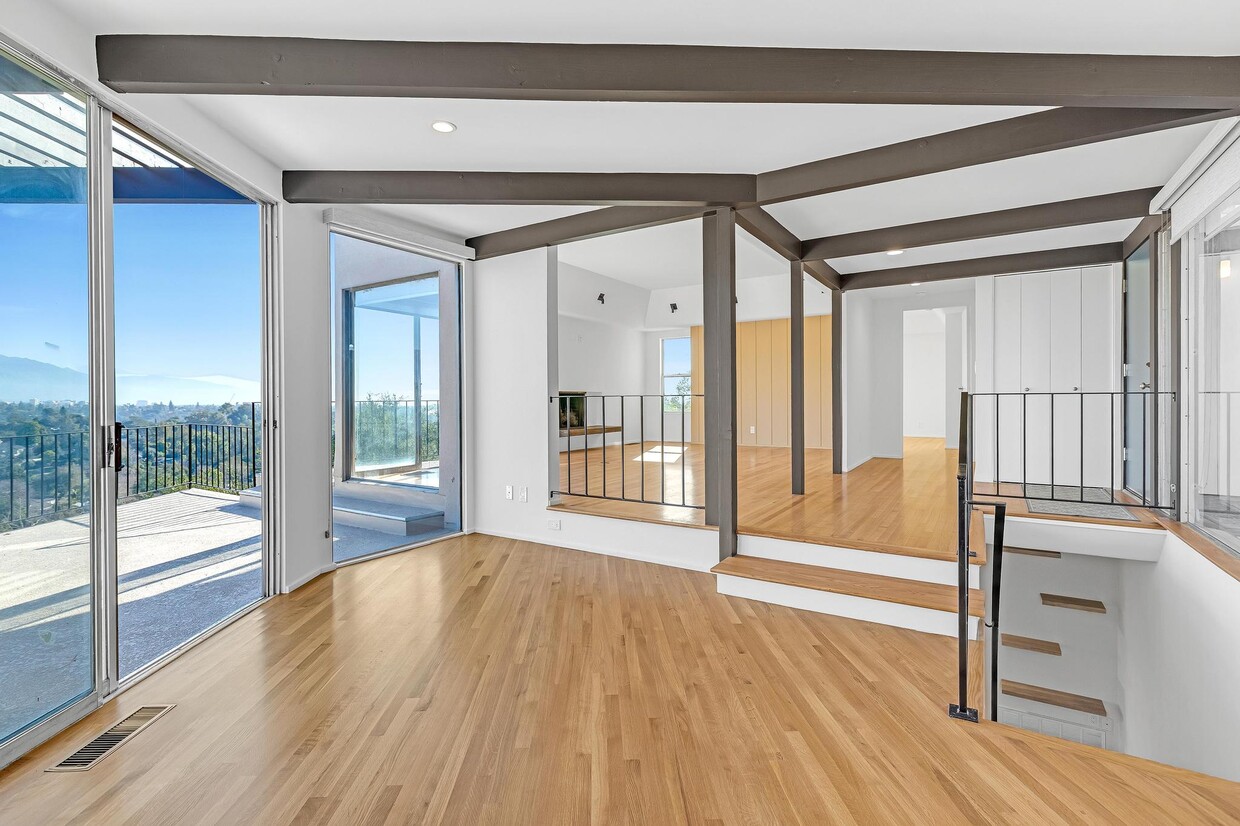
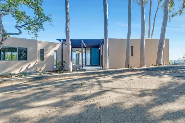
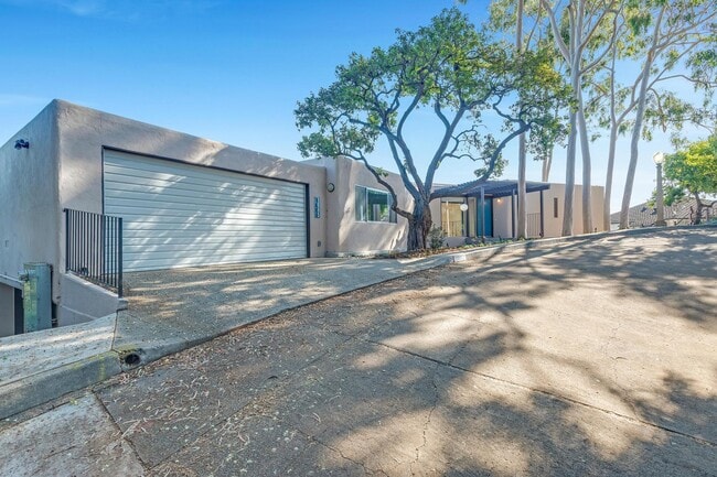
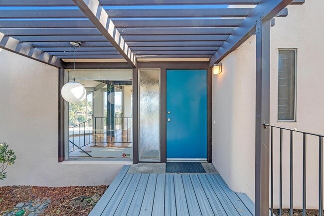
Poppy Peak, in the San Rafael Hills of southwest Pasadena, is one of the city's many historic districts. Named for the profuse blooms of native California poppies, Poppy Peak is predominantly comprised of mid-century modernist homes. 1685 Poppy Peak was built in 1961 and commands incredible 270-degree views of Pasadena to the San Gabriel Mountains beyond. The home has just been restored and expanded. Bold geometric architecture with post-and-beam elements intertwines with floor-to-ceiling windows providing natural light and spectacular views. The redesigned kitchen features a center island, ample storage and stainless-steel appliances. Entertaining is effortless thanks to a family/great room complete with a 2nd kitchenette and 2 expansive decks. The home offers 4 bedrooms and 3 ½ baths with just over 2,800 square feet of living space. Washer/Dryer hookups on both floors add convenience. Updated HVAC, plumbing and electrical systems provide comfort and peace of mind. The finished 2-car garage is equipped with 2 electric car charge points, built-in storage and a utility sink. The hillside lot has been thoughtfully landscaped with low maintenance plantings and automatic irrigation. Enjoy the convenience of being close to Downtown LA, Old Town Pasadena, the Rose Bowl, Eagle Rock, and easy access to multiple freeways. Rental Terms: Annual: $7,950 Per Month
1685 Poppy Peak Dr is a house located in Los Angeles County and the 91105 ZIP Code. This area is served by the Pasadena Unified attendance zone.
House Features
- Air Conditioning
- Hardwood Floors
- Tile Floors
- Package Service
- Laundry Facilities
- Controlled Access
Location
Get Directions
Annandale is nestled in a quaint, high-end section of Pasadena in the outskirts of Los Angeles. Many visitors pass through Annandale to cross the landmark Colorado Street Bridge or exit the Ventura Freeway heading to events at the Rose Bowl. The neighborhood contains mostly million-dollar homes and grand estates, along with a few upscale rental properties. The only commercial zone rests along Colorado Boulevard, comprising of a few small businesses. The Arroyo Seco defines the eastern border, a dry riverbed that extends from the San Gabriel Mountains down to Elysian Park. Annandale sits only two miles west of Pasadena City Hall and nine miles northeast of Downtown Los Angeles.
Learn more about living in AnnandaleBelow are rent ranges for similar nearby apartments
Amenities
- Air Conditioning
- Hardwood Floors
- Tile Floors
- Package Service
- Laundry Facilities
- Controlled Access
Education
| Colleges & Universities | Distance | ||
|---|---|---|---|
| Colleges & Universities | Distance | ||
| Drive: | 8 min | 3.0 mi | |
| Drive: | 9 min | 3.5 mi | |
| Drive: | 8 min | 3.9 mi | |
| Drive: | 11 min | 4.4 mi |
1685 Poppy Peak Dr is within 8 minutes or 3.0 miles from Art Center College of Design. It is also near Occidental College and Fuller Theological Seminary.
Schools


Charter Elementary School
Grades K-5
75 Students
Nearby
Public Elementary & Middle School
Grades K-8
648 Students
Attendance Zone
Public Middle & High School
Grades 6-12
1,117 Students
Attendance Zone
Private Elementary & Middle School
Grades PK-8
237 Students
Nearby
Private Elementary, Middle & High School
Grades 1-12
71 Students
Nearby
School data provided by
 The GreatSchools Rating helps parents compare schools within a state based on a variety of school quality indicators and provides a helpful picture of how effectively each school serves all of its students. Ratings are on a scale of 1 (below average) to 10 (above average) and can include test scores, college readiness, academic progress, advanced courses, equity, discipline and attendance data. We also advise parents to visit schools, consider other information on school performance and programs, and consider family needs as part of the school selection process.
View GreatSchools Rating Methodology
Data provided by GreatSchools.org © 2025. All rights reserved.
View GreatSchools Rating Methodology
Data provided by GreatSchools.org © 2025. All rights reserved.
Transportation options available in Pasadena include Fillmore Station, located 2.5 miles from 1685 Poppy Peak Dr. 1685 Poppy Peak Dr is near Bob Hope, located 15.5 miles or 23 minutes away, and Los Angeles International, located 22.7 miles or 37 minutes away.
| Transit / Subway | Distance | ||
|---|---|---|---|
| Transit / Subway | Distance | ||
|
|
Drive: | 7 min | 2.5 mi |
|
|
Drive: | 7 min | 2.5 mi |
|
|
Drive: | 7 min | 2.8 mi |
|
|
Drive: | 7 min | 3.2 mi |
|
|
Drive: | 7 min | 3.2 mi |
| Commuter Rail | Distance | ||
|---|---|---|---|
| Commuter Rail | Distance | ||
|
|
Drive: | 15 min | 7.6 mi |
|
|
Drive: | 17 min | 7.7 mi |
|
|
Drive: | 12 min | 7.9 mi |
|
|
Drive: | 15 min | 10.0 mi |
| Drive: | 18 min | 11.7 mi |
| Airports | Distance | ||
|---|---|---|---|
| Airports | Distance | ||
|
Bob Hope
|
Drive: | 23 min | 15.5 mi |
|
Los Angeles International
|
Drive: | 37 min | 22.7 mi |
Time and distance from 1685 Poppy Peak Dr.
| Shopping Centers | Distance | ||
|---|---|---|---|
| Shopping Centers | Distance | ||
| Drive: | 4 min | 1.7 mi | |
| Drive: | 5 min | 2.0 mi | |
| Drive: | 6 min | 2.4 mi |
1685 Poppy Peak Dr has 3 shopping centers within 2.4 miles, which is about a 6-minute drive. The miles and minutes will be for the farthest away property.
| Parks and Recreation | Distance | ||
|---|---|---|---|
| Parks and Recreation | Distance | ||
|
Kidspace Children's Museum
|
Drive: | 7 min | 2.9 mi |
|
Audubon Center at Debs Park
|
Drive: | 8 min | 3.7 mi |
|
Jet Propulsion Laboratory
|
Drive: | 10 min | 5.6 mi |
|
Elyria Canyon Park
|
Drive: | 13 min | 5.9 mi |
|
Huntington Botanical Gardens
|
Drive: | 14 min | 6.2 mi |
1685 Poppy Peak Dr has 5 parks within 6.2 miles, including Kidspace Children's Museum, Audubon Center at Debs Park, and Elyria Canyon Park.
| Hospitals | Distance | ||
|---|---|---|---|
| Hospitals | Distance | ||
| Drive: | 6 min | 2.1 mi | |
| Drive: | 9 min | 4.5 mi | |
| Drive: | 13 min | 5.2 mi |
1685 Poppy Peak Dr has 3 hospitals within 5.2 miles, the nearest is Huntington Memorial Hospital which is 2.1 miles away and a 6 minute drive.
| Military Bases | Distance | ||
|---|---|---|---|
| Military Bases | Distance | ||
| Drive: | 34 min | 24.3 mi | |
| Drive: | 47 min | 31.7 mi |
1685 Poppy Peak Dr is 24.3 miles from Los Angeles Air Force Base, and is convenient to other military bases, including Los Alamitos Army Airfield.
You May Also Like
Similar Rentals Nearby


What Are Walk Score®, Transit Score®, and Bike Score® Ratings?
Walk Score® measures the walkability of any address. Transit Score® measures access to public transit. Bike Score® measures the bikeability of any address.
What is a Sound Score Rating?
A Sound Score Rating aggregates noise caused by vehicle traffic, airplane traffic and local sources

1685 Poppy Peak Dr
Pasadena, CA 91105