
$3,700
/ Month
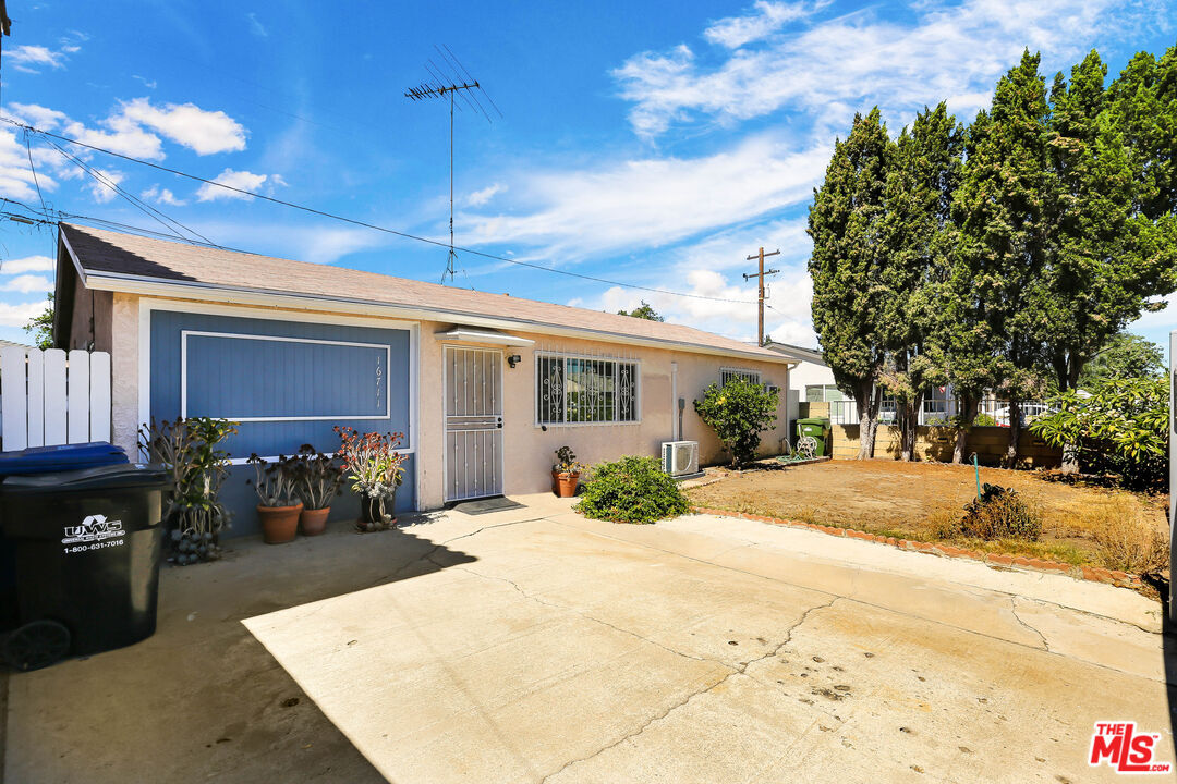
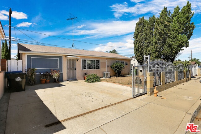
16711 Mapes Ave
Artesia, CA 90703
Today
|
Edit
Favorites
310-357-3166
-
Bedrooms
3
-
Bathrooms
2
-
Square Feet
1,048 sq ft
-
Available
Available Now
Highlight
- Pets Allowed
16711 Mapes Ave

Favorites
About This Home
$3,700 deposit,
Available Now
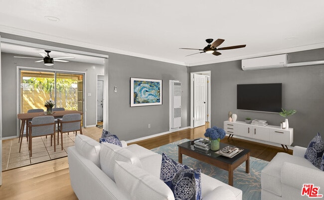
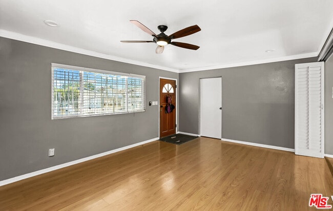
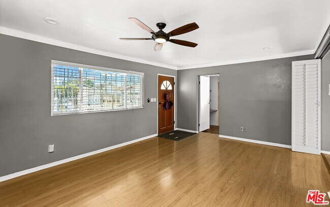
Beautiful home in a great location! 3 bedrooms and 2 bathrooms. Bright and spacious living room, remodeled kitchen with granite counters and appliances! Decent sized bedrooms with good closet space. Laundry room with washer and dryer. Window air conditioning units and ceiling fans. Gated parking area. Close to Cerritos College, Costco the 91, 605, 105 freeways. MLS# 25598387
16711 Mapes Ave is a house located in Los Angeles County and the 90703 ZIP Code. This area is served by the ABC Unified attendance zone.
* Price shown is base rent. Excludes user-selected optional fees and variable or usage-based fees and required charges due at or prior to move-in or at move-out. Price, availability, fees, and any applicable rent special are subject to change without notice.
* Square footage definitions vary. Displayed square footage is approximate.
Fees and Policies
The fees below are based on community-supplied data and may exclude additional fees and utilities.
- One-Time Basics
- Due at Move-In
- Security Deposit - Refundable$3,700
- Due at Move-In
- Dogs
- Allowed
- Cats
- Allowed
Property Fee Disclaimer: Based on community-supplied data and independent market research. Subject to change without notice. May exclude fees for mandatory or optional services and usage-based utilities.
House Features
Washer/Dryer
Washer/Dryer Hookup
Microwave
Refrigerator
- Washer/Dryer
- Washer/Dryer Hookup
- Ceiling Fans
- Disposal
- Microwave
- Refrigerator
- Tile Floors
- Vinyl Flooring
Contact
- Listed by Charles Chamorro | eXp Realty of California Inc
- Phone Number
- Contact
-
Source
 MLS(TM)/CLAW
Copyright 2025 TheMLS/CLAW. All rights reserved. Information is deemed reliable but not guaranteed.
Location
Get Directions
Amenities
- Washer/Dryer
- Washer/Dryer Hookup
- Ceiling Fans
- Disposal
- Microwave
- Refrigerator
- Tile Floors
- Vinyl Flooring
ABC is a lively neighborhood conveniently located 15 miles north of Long Beach and 20 miles south of Los Angeles. The area has a dense population with an abundance of apartments and single-family homes for rent, as well as premier shopping destinations. The Los Cerritos Center, conveniently situated off Interstate 605, attracts shoppers from the surrounding areas. On the other side of town off Highway 91, Cerritos Towne Center provides more retail and dining choices. Quaint boutiques and local eateries are located off Pioneer Boulevard, offering a nice contrast to the large retail centers. More great amenities in town include a few peaceful parks and trails that dot the neighborhood like Liberty Park and Fitness Center.
Learn more about living in ABC
Education
| Colleges & Universities | Distance | ||
|---|---|---|---|
| Colleges & Universities | Distance | ||
| Walk: | 12 min | 0.7 mi | |
| Drive: | 13 min | 6.3 mi | |
| Drive: | 13 min | 6.6 mi | |
| Drive: | 13 min | 7.5 mi |
16711 Mapes Ave is within 12 minutes or 0.7 mile from Cerritos College. It is also near Long Beach City Coll. and Biola University.
Schools


Public Elementary School
Grades K-6
649 Students
Attendance Zone
Public Elementary School
Grades K-6
557 Students
Nearby
Public Middle School
Grades 7-8
522 Students
Attendance Zone
Public High School
Grades 9-12
1,682 Students
Attendance Zone
Private Elementary, Middle & High School
Grades PK-12
1,159 Students
Nearby
School data provided by
 The GreatSchools Rating helps parents compare schools within a state based on a variety of school quality indicators and provides a helpful picture of how effectively each school serves all of its students. Ratings are on a scale of 1 (below average) to 10 (above average) and can include test scores, college readiness, academic progress, advanced courses, equity, discipline and attendance data. We also advise parents to visit schools, consider other information on school performance and programs, and consider family needs as part of the school selection process.
View GreatSchools Rating Methodology
Data provided by GreatSchools.org © 2025. All rights reserved.
View GreatSchools Rating Methodology
Data provided by GreatSchools.org © 2025. All rights reserved.
Transportation options available in Artesia include Norwalk, located 3.0 miles from 16711 Mapes Ave. 16711 Mapes Ave is near Long Beach (Daugherty Field), located 9.2 miles or 17 minutes away, and Los Angeles International, located 22.5 miles or 30 minutes away.
| Transit / Subway | Distance | ||
|---|---|---|---|
| Transit / Subway | Distance | ||
|
|
Drive: | 5 min | 3.0 mi |
|
|
Drive: | 9 min | 5.4 mi |
|
|
Drive: | 14 min | 9.9 mi |
|
|
Drive: | 15 min | 10.0 mi |
|
|
Drive: | 18 min | 12.3 mi |
| Commuter Rail | Distance | ||
|---|---|---|---|
| Commuter Rail | Distance | ||
|
|
Drive: | 9 min | 4.3 mi |
|
|
Drive: | 13 min | 8.8 mi |
|
|
Drive: | 15 min | 9.7 mi |
|
|
Drive: | 17 min | 11.0 mi |
|
|
Drive: | 18 min | 12.2 mi |
| Airports | Distance | ||
|---|---|---|---|
| Airports | Distance | ||
|
Long Beach (Daugherty Field)
|
Drive: | 17 min | 9.2 mi |
|
Los Angeles International
|
Drive: | 30 min | 22.5 mi |
Time and distance from 16711 Mapes Ave.
| Shopping Centers | Distance | ||
|---|---|---|---|
| Shopping Centers | Distance | ||
| Walk: | 13 min | 0.7 mi | |
| Walk: | 14 min | 0.7 mi | |
| Walk: | 17 min | 0.9 mi |
16711 Mapes Ave has 3 shopping centers within 0.9 mile, which is about a 17-minute walk. The miles and minutes will be for the farthest away property.
| Parks and Recreation | Distance | ||
|---|---|---|---|
| Parks and Recreation | Distance | ||
|
El Dorado Nature Center
|
Drive: | 11 min | 6.7 mi |
|
El Dorado East Regional Park
|
Drive: | 13 min | 7.5 mi |
|
Earl Burns Miller Japanese Garden
|
Drive: | 16 min | 8.2 mi |
|
Pio Pico State Historic Park
|
Drive: | 12 min | 9.1 mi |
|
Colorado Lagoon
|
Drive: | 17 min | 11.0 mi |
16711 Mapes Ave has 5 parks within 11.0 miles, including El Dorado Nature Center, El Dorado East Regional Park, and Earl Burns Miller Japanese Garden.
| Hospitals | Distance | ||
|---|---|---|---|
| Hospitals | Distance | ||
| Walk: | 19 min | 1.0 mi | |
| Drive: | 5 min | 2.7 mi | |
| Drive: | 8 min | 4.7 mi |
16711 Mapes Ave has 3 hospitals within 4.7 miles, the nearest is College Hospitals which is 1.0 mile away and a 19 minute walk.
| Military Bases | Distance | ||
|---|---|---|---|
| Military Bases | Distance | ||
| Drive: | 17 min | 10.1 mi | |
| Drive: | 32 min | 20.4 mi |
16711 Mapes Ave is 10.1 miles from Los Alamitos Army Airfield, and is convenient to other military bases, including Long Beach Naval Station.
You May Also Like
Similar Rentals Nearby


What Are Walk Score®, Transit Score®, and Bike Score® Ratings?
Walk Score® measures the walkability of any address. Transit Score® measures access to public transit. Bike Score® measures the bikeability of any address.
What is a Sound Score Rating?
A Sound Score Rating aggregates noise caused by vehicle traffic, airplane traffic and local sources

16711 Mapes Ave
Artesia, CA 90703