$3,195
Total Monthly Price
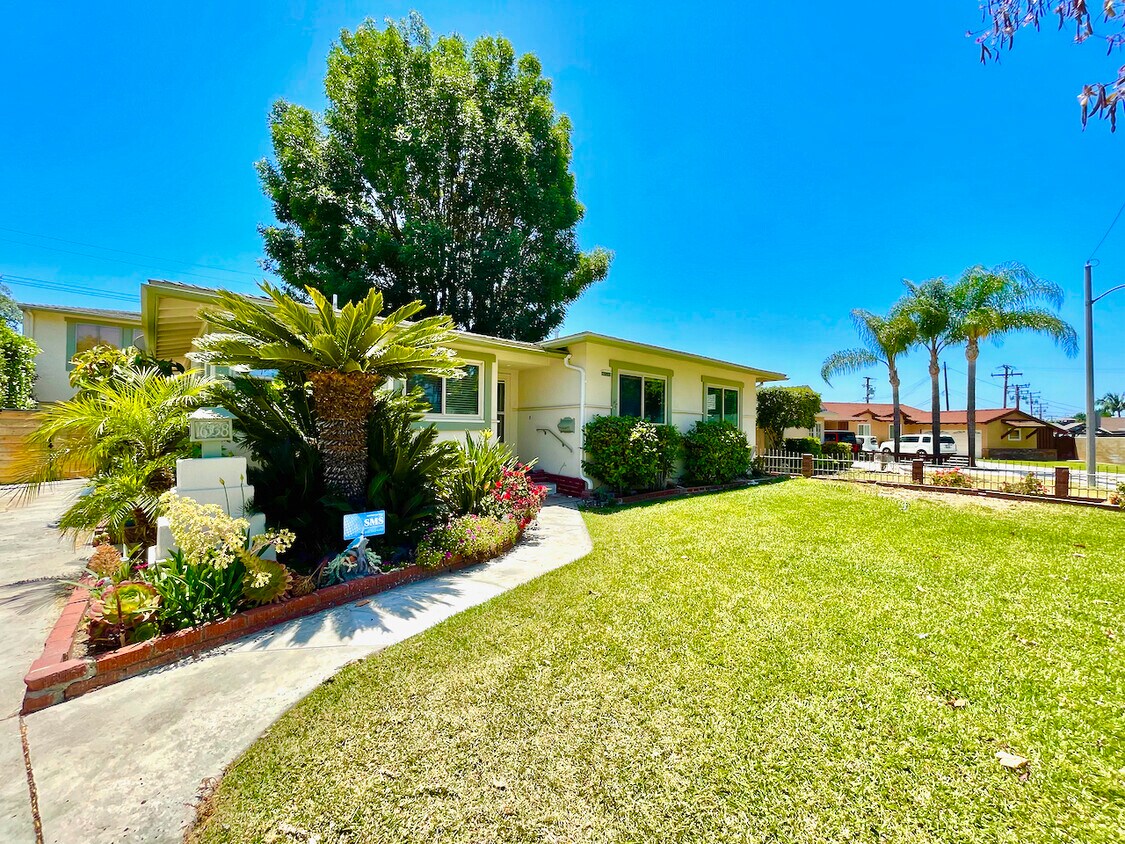
16538 Ancep St
Whittier, CA 90603
Favorites
-
Bedrooms
3
-
Bathrooms
1.5
-
Square Feet
1,279 sq ft
Highlights
- Pets Allowed
- Patio
- Hardwood Floors
- Fireplace
16538 Ancep St

Favorites
About This Home
12 Month Lease,
$3,195 deposit
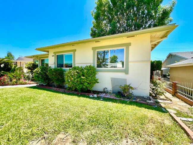
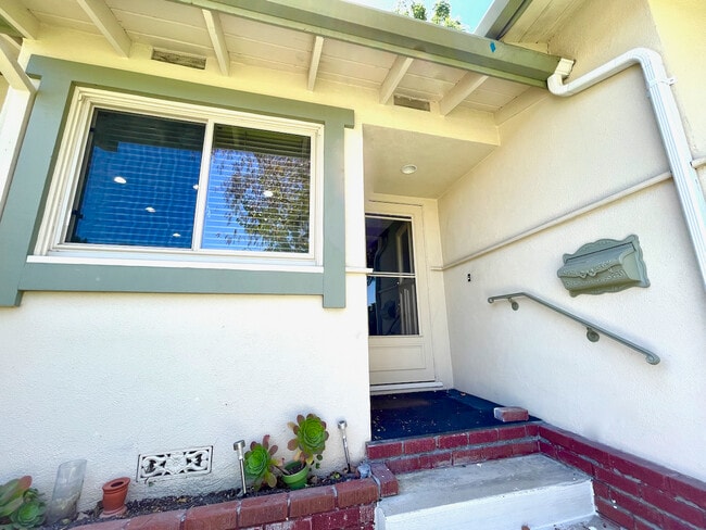
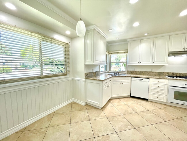
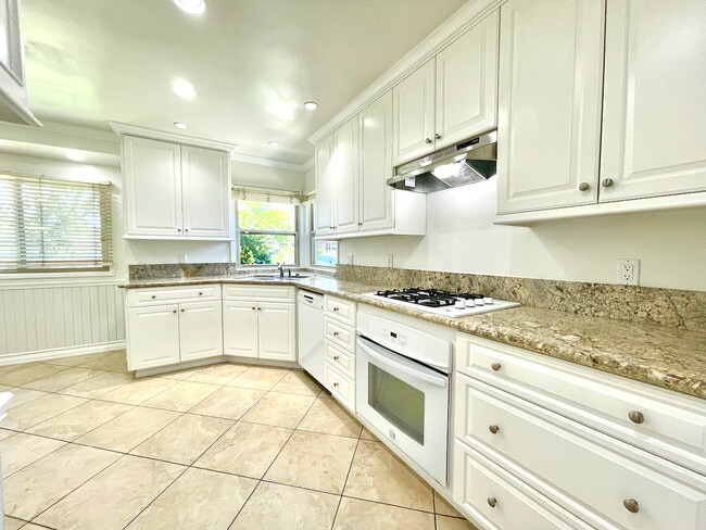
Due Upon Approval at Lease Signing: First Full Month’s Rent + Security Deposit AVAILABLE NOW! Small pet considered with additional security deposit. A stunning house in Whittier with a beautiful green backyard and patio area! Gorgeous modern, vinyl hardwood flooring throughout. The sun porch at the back of the home has plenty of space for another set of table and chairs. A perfect setting for a home cooked meal while enjoying the California breeze and sun. The kitchen features stunning granite counters, light cabinets, recessed lighting, plus a stove/oven and dishwasher. The living room and dining area boast beautiful natural light and a gorgeous gas fireplace. All three bedrooms are on the opposite side of the kitchen and each come with large closet space. Small pet considered with additional security deposit. Trash, sewer are included in the rent. There is a large driveway, plus plenty of street parking. Make an appointment with Lindsey to view this spacious beauty today! Due Upon Approval at Lease Signing: First Full Month’s Rent + Security Deposit
16538 Ancep St is a house located in Los Angeles County and the 90603 ZIP Code. This area is served by the Lowell Joint School District attendance zone.
* Price shown is total price based on community-supplied monthly required fees. Excludes user-selected optional fees and variable or usage-based fees and required charges due at or prior to move-in or at move-out. Price, availability, fees, and any applicable rent special are subject to change without notice.
* Square footage definitions vary. Displayed square footage is approximate.
House Features
Air Conditioning
Dishwasher
Washer/Dryer Hookup
Hardwood Floors
- Washer/Dryer Hookup
- Air Conditioning
- Heating
- Ceiling Fans
- Cable Ready
- Storage Space
- Tub/Shower
- Fireplace
- Dishwasher
- Granite Countertops
- Kitchen
- Oven
- Hardwood Floors
- Dining Room
- Patio
- Porch
Fees and Policies
The fees listed below are community-provided and may exclude utilities or add-ons. All payments are made directly to the property and are non-refundable unless otherwise specified.
- One-Time Move-In Fees
-
Broker Fee$0
- Dogs Allowed
-
Fees not specified
- Cats Allowed
-
Fees not specified
- Parking
-
Other--
Details
Utilities Included
-
Gas
-
Trash Removal
-
Sewer
Contact
Location
Get Directions
Located 14 miles southeast of Los Angeles, the tree-lined neighborhood of East La Mirada offers a suburban respite with a small-town feel. The original Southern Pacific Railroad depot still stands in Whittier, not far from the first home built in 1867, which now operates as the John Bailey House museum. Apartment buildings dot the area's southwest corner, along with single-family houses for rent.
Shops and restaurants bookend quiet residential blocks on Whittier Boulevard and Imperial Highway. Toast, a popular restaurant, dishes up classic breakfast fare alongside California favorites, while La Casita Olvera serves tasty Mexican food. After dinner, head to the La Mirada Theatre for a concert or Broadway musical. Locals appreciate the neighborhood's close proximity to the San Gabriel Valley and Orange County.
Learn more about living in East La Mirada
Education
| Colleges & Universities | Distance | ||
|---|---|---|---|
| Colleges & Universities | Distance | ||
| Drive: | 10 min | 4.7 mi | |
| Drive: | 10 min | 4.7 mi | |
| Drive: | 14 min | 7.6 mi | |
| Drive: | 18 min | 9.4 mi |
16538 Ancep St is within 10 minutes or 4.7 miles from Biola University. It is also near Whittier College and Fullerton College.
Schools


Public Elementary School
Grades K-5
470 Students
Nearby
Public Elementary School
Grades K-5
413 Students
Attendance Zone
Public Middle School
Grades 6-8
687 Students
Attendance Zone
Public High School
Grades 9-12
1,881 Students
Attendance Zone
Private Elementary School
Grades PK-5
239 Students
Nearby
School data provided by
 The GreatSchools Rating helps parents compare schools within a state based on a variety of school quality indicators and provides a helpful picture of how effectively each school serves all of its students. Ratings are on a scale of 1 (below average) to 10 (above average) and can include test scores, college readiness, academic progress, advanced courses, equity, discipline and attendance data. We also advise parents to visit schools, consider other information on school performance and programs, and consider family needs as part of the school selection process.
View GreatSchools Rating Methodology
Data provided by GreatSchools.org © 2026. All rights reserved.
View GreatSchools Rating Methodology
Data provided by GreatSchools.org © 2026. All rights reserved.
Transportation options available in Whittier include Norwalk, located 9.9 miles from 16538 Ancep St. 16538 Ancep St is near Long Beach (Daugherty Field), located 20.3 miles or 33 minutes away, and John Wayne/Orange County, located 25.0 miles or 33 minutes away.
| Transit / Subway | Distance | ||
|---|---|---|---|
| Transit / Subway | Distance | ||
|
|
Drive: | 19 min | 9.9 mi |
|
|
Drive: | 19 min | 10.7 mi |
| Commuter Rail | Distance | ||
|---|---|---|---|
| Commuter Rail | Distance | ||
|
|
Drive: | 12 min | 5.9 mi |
|
|
Drive: | 10 min | 6.0 mi |
|
|
Drive: | 15 min | 8.4 mi |
|
|
Drive: | 22 min | 11.1 mi |
|
|
Drive: | 19 min | 11.3 mi |
| Airports | Distance | ||
|---|---|---|---|
| Airports | Distance | ||
|
Long Beach (Daugherty Field)
|
Drive: | 33 min | 20.3 mi |
|
John Wayne/Orange County
|
Drive: | 33 min | 25.0 mi |
Getting Around
 What do Walkability, Transit, Drivability, and Bikeability mean?
Walkability measures the walking distance to day-to-day needs.
Transit measures access to public transportation.
Drivability measures congestion, parking availability, and access to major roads.
Bikeability measures the suitability for cycling.
How It Works
What do Walkability, Transit, Drivability, and Bikeability mean?
Walkability measures the walking distance to day-to-day needs.
Transit measures access to public transportation.
Drivability measures congestion, parking availability, and access to major roads.
Bikeability measures the suitability for cycling.
How It Works
Fairly Walkable
Walkability
50
/ 100
Limited Public Transit
Transit
30
/ 100
Moderately Drivable
Drivability
70
/ 100
Somewhat Bikeable
Bikeability
30
/ 100
Scores provided by
-
Soundscore™
-
/ 100
Traffic
-Airport
-Businesses
-Scores provided by
HowLoud What is a Sound Score Rating? A Sound Score Rating aggregates noise caused by vehicle traffic, airplane traffic and local sources. How It WorksTime and distance from 16538 Ancep St.
| Shopping Centers | Distance | ||
|---|---|---|---|
| Shopping Centers | Distance | ||
| Walk: | 5 min | 0.3 mi | |
| Walk: | 8 min | 0.5 mi | |
| Walk: | 9 min | 0.5 mi |
16538 Ancep St has 3 shopping centers within 0.5 mile, which is about a 9-minute walk. The miles and minutes will be for the farthest away property.
| Parks and Recreation | Distance | ||
|---|---|---|---|
| Parks and Recreation | Distance | ||
|
La Habra Historical Museum
|
Drive: | 5 min | 2.7 mi |
|
Children's Museum at La Habra
|
Drive: | 6 min | 2.8 mi |
|
Pio Pico State Historic Park
|
Drive: | 14 min | 6.8 mi |
|
Craig Regional Park
|
Drive: | 16 min | 8.0 mi |
|
Schabarum Regional Park
|
Drive: | 16 min | 8.0 mi |
16538 Ancep St has 5 parks within 8.0 miles, including La Habra Historical Museum, Children's Museum at La Habra, and Schabarum Regional Park.
| Hospitals | Distance | ||
|---|---|---|---|
| Hospitals | Distance | ||
| Drive: | 4 min | 2.0 mi | |
| Drive: | 10 min | 4.7 mi | |
| Drive: | 11 min | 6.1 mi |
16538 Ancep St has 3 hospitals within 6.1 miles, the nearest is Whittier Hospital Medical Center which is 2.0 miles away and a 4 minute drive.
| Military Bases | Distance | ||
|---|---|---|---|
| Military Bases | Distance | ||
| Drive: | 25 min | 14.1 mi | |
| Drive: | 37 min | 26.2 mi | |
| Drive: | 48 min | 28.6 mi |
16538 Ancep St has 3 military bases within 28.6 miles, the nearest is Los Alamitos Army Airfield which is 14.1 miles away and a 25 minute drive.
Amenities
- Washer/Dryer Hookup
- Air Conditioning
- Heating
- Ceiling Fans
- Cable Ready
- Storage Space
- Tub/Shower
- Fireplace
- Dishwasher
- Granite Countertops
- Kitchen
- Oven
- Hardwood Floors
- Dining Room
- Patio
- Porch
16538 Ancep St Photos
What Are Walk Score®, Transit Score®, and Bike Score® Ratings?
Walk Score® measures the walkability of any address. Transit Score® measures access to public transit. Bike Score® measures the bikeability of any address.
What is a Sound Score Rating?
A Sound Score Rating aggregates noise caused by vehicle traffic, airplane traffic and local sources.

16538 Ancep St
Whittier, CA 90603