
$2,800 / Month
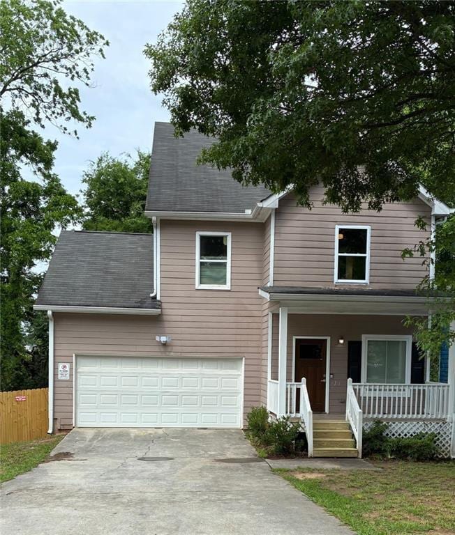
165 Walnut St SW
Atlanta, GA 30314
Today
Favorites
404-545-7165
-
Bedrooms
5
-
Bathrooms
2.5
-
Square Feet
1,966 sq ft
-
Available
Available Now
Highlights
- City View
- Colonial Architecture
- Deck
- Property is near public transit
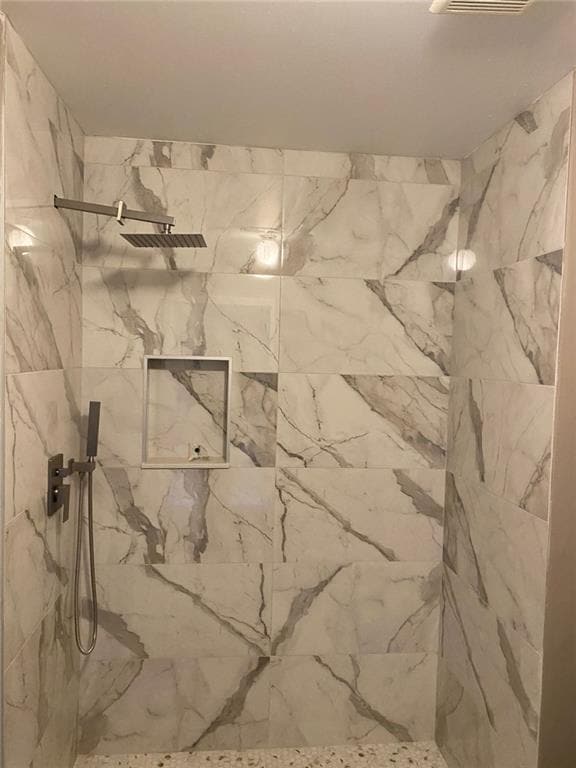
- Double Shower
- Wood Flooring
165 Walnut St SW

Favorites
About This Home
$500 deposit,
Available Now
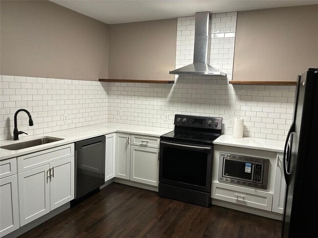
Beautiful remodel with new kitchen and baths. 4 bedrooms upstairs,1 bedroom or study on main. 2 full baths,1 half bath. Exterior deck. Wood flooring throughout. New,fully fenced backyard. Unique to this area,this property includes an attached 2 car garage w/ driveway. Lawn maintenance and pest control included. Monitored Security system. Exterior security light. Close proximity to Atlanta University campuses including Clark Atlanta,Morehouse,Morris Brown,and Spelman. Near Georgia State,Georgia Tech,the Mercedes Benz Stadium,Midtown and the belt line. Appointment required.
165 Walnut St SW is a house located in Fulton County and the 30314 ZIP Code. This area is served by the Atlanta Public Schools attendance zone.
* Price shown is base rent and may not include non-optional fees and utilities.
Price, availability, fees, and any applicable rent special are subject to change without notice.
* Square footage definitions vary. Displayed square footage is approximate.
Home Details
Home Type
Single Family Detached Home
Year Built
Built in 2005
Attic
Pull Down Stairs to Attic
Basement
Crawl Space
Bedrooms and Bathrooms
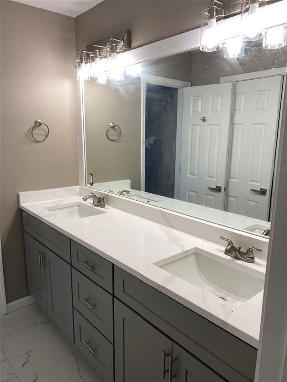
Double Shower
Separate Shower in Primary Bathroom
Dual Vanity Sinks in Primary Bathroom
5 Bedrooms | 1 Main Level Bedroom
2.5 Bathrooms
Low Flow Plumbing Fixtures
Home Design
Colonial Architecture
Shingle Roof
HardiePlank Type
Home Security
Carbon Monoxide Detectors
Security Lights
Interior Spaces
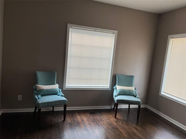
Wood Flooring
Formal Dining Room
Ceiling height of 9 feet on the main level
Ceiling Fan
ENERGY STAR Qualified Windows
Roommate Plan
1,966 Sq Ft Home
2-Story Property
Furniture Can Be Negotiated
Kitchen
Solid Surface Countertops
White Kitchen Cabinets
Electric Range
Dishwasher
Laundry
Laundry Room
Electric Dryer Hookup
Listing and Financial Details
$2,700 Move-In Fee
Renewal Option
$50 Application Fee
Assessor Parcel Number 14 008400050328
Location
Property is near public transit
Property is near the Beltline
Lot Details
8,799 Sq Ft Lot
No Common Walls
Private Entrance
Wood Fence
Back Yard Fenced
Lot Dimensions are 51 x 175
Outdoor Features
Deck
Exterior Lighting
Parking
2 Car Garage
Garage Door Opener
Schools
M.R. Hollis Innovation Academy Elementary And Middle School
Booker T. Washington High School
Utilities
Forced Air Heating and Cooling System
Cable TV Available
Views
City Views
Community Details
Overview
Application Fee Required
Pet Policy
Call for details about the types of pets allowed
Pet Deposit $500
Security
Security Service
Fees and Policies
The fees below are based on community-supplied data and may exclude additional fees and utilities.
Contact
- Listed by LAURYL LAVALLE | Chapman Hall Realtors
- Phone Number
- Contact
-
Source
 First Multiple Listing Service, Inc.
Copyright © 2025 First Multiple Listing Service, Inc. All rights reserved. All information provided by the listing agent/broker is deemed reliable but is not guaranteed and should be independently verified.
Location
Get Directions
Amenities
- Dishwasher
- Range
“The Westside” can mean a lot of different things to a lot of different Atlantans. However, the sprawling area that stretches west from I-85, past the Perimeter, and out towards GA-70 is experiencing massive amounts of growth and development in every neighborhood. With the recent addition of the Westside Trail, part the Atlanta BeltLine project, interest in this prime locale has skyrocketed, spurring renters to go west.
The Westside encompasses a large number of historic in-town neighborhoods and districts, plus two of the city’s most distinctive universities: Spelman College and Clark Atlanta University. With plans for the 280-acre Westside Park underway, this largely residential area will become another distinct facet in metropolitan Atlanta. From the historic homes in Washington Park and Ashview Heights to the impressive new apartment high-rises bordering Midtown, there’s something for everyone in this up-and-coming Atlanta locale.
Learn more about living in Westside Atlanta
Education
| Colleges & Universities | Distance | ||
|---|---|---|---|
| Colleges & Universities | Distance | ||
| Walk: | 8 min | 0.4 mi | |
| Walk: | 17 min | 0.9 mi | |
| Walk: | 18 min | 1.0 mi | |
| Drive: | 4 min | 1.3 mi |
165 Walnut St SW is within 8 minutes or 0.4 mile from Clark Atlanta University. It is also near Spelman College and Morehouse School of Medicine.
Schools


Public Elementary & Middle School
Grades PK-8
653 Students
Attendance Zone
Public Middle School
Grades 6-8
399 Students
Nearby
Public High School
Grades 9-12
831 Students
Attendance Zone
Private Elementary, Middle & High School
Grades 3-10
7 Students
Nearby
Private Elementary School
Grades PK-6
Nearby
Private Middle & High School
Grades 6-12
Nearby
School data provided by
 The GreatSchools Rating helps parents compare schools within a state based on a variety of school quality indicators and provides a helpful picture of how effectively each school serves all of its students. Ratings are on a scale of 1 (below average) to 10 (above average) and can include test scores, college readiness, academic progress, advanced courses, equity, discipline and attendance data. We also advise parents to visit schools, consider other information on school performance and programs, and consider family needs as part of the school selection process.
View GreatSchools Rating Methodology
Data provided by GreatSchools.org © 2025. All rights reserved.
View GreatSchools Rating Methodology
Data provided by GreatSchools.org © 2025. All rights reserved.
Transportation options available in Atlanta include Vine City Station, located 0.6 mile from 165 Walnut St SW. 165 Walnut St SW is near Hartsfield - Jackson Atlanta International, located 10.0 miles or 17 minutes away.
| Transit / Subway | Distance | ||
|---|---|---|---|
| Transit / Subway | Distance | ||
|
|
Walk: | 11 min | 0.6 mi |
|
|
Walk: | 19 min | 1.0 mi |
|
|
Walk: | 19 min | 1.0 mi |
|
|
Walk: | 19 min | 1.0 mi |
|
|
Drive: | 4 min | 1.6 mi |
| Commuter Rail | Distance | ||
|---|---|---|---|
| Commuter Rail | Distance | ||
|
|
Drive: | 9 min | 4.7 mi |
| Airports | Distance | ||
|---|---|---|---|
| Airports | Distance | ||
|
Hartsfield - Jackson Atlanta International
|
Drive: | 17 min | 10.0 mi |
Time and distance from 165 Walnut St SW.
| Shopping Centers | Distance | ||
|---|---|---|---|
| Shopping Centers | Distance | ||
| Walk: | 14 min | 0.8 mi | |
| Walk: | 20 min | 1.1 mi | |
| Drive: | 3 min | 1.4 mi |
165 Walnut St SW has 3 shopping centers within 1.4 miles, which is about a 3-minute walk. The miles and minutes will be for the farthest away property.
| Parks and Recreation | Distance | ||
|---|---|---|---|
| Parks and Recreation | Distance | ||
|
Park Pride
|
Walk: | 19 min | 1.0 mi |
|
The Georgia Capitol Museum
|
Drive: | 3 min | 1.5 mi |
|
Georgia Aquarium
|
Drive: | 3 min | 1.6 mi |
|
Imagine It! The Children's Museum of Atlanta
|
Drive: | 4 min | 1.8 mi |
|
West Atlanta Watershed Alliance (WAWA)
|
Drive: | 6 min | 3.1 mi |
165 Walnut St SW has 5 parks within 3.1 miles, including Park Pride, The Georgia Capitol Museum, and Imagine It! The Children's Museum of Atlanta.
| Hospitals | Distance | ||
|---|---|---|---|
| Hospitals | Distance | ||
| Drive: | 4 min | 2.0 mi | |
| Drive: | 5 min | 2.6 mi | |
| Drive: | 6 min | 3.0 mi |
165 Walnut St SW has 3 hospitals within 3.0 miles, the nearest is Grady Memorial Hospital which is 2.0 miles away and a 4 minute drive.
| Military Bases | Distance | ||
|---|---|---|---|
| Military Bases | Distance | ||
| Drive: | 8 min | 3.8 mi | |
| Drive: | 25 min | 12.9 mi |
165 Walnut St SW is 3.8 miles from Fort McPherson, and is convenient to other military bases, including Fort Gillem.
You May Also Like
Similar Rentals Nearby
-
-

-

-

-

-

-
-
1 / 28

-
-


What Are Walk Score®, Transit Score®, and Bike Score® Ratings?
Walk Score® measures the walkability of any address. Transit Score® measures access to public transit. Bike Score® measures the bikeability of any address.
What is a Sound Score Rating?
A Sound Score Rating aggregates noise caused by vehicle traffic, airplane traffic and local sources

165 Walnut St SW
Atlanta, GA 30314