
$2,895 / Month
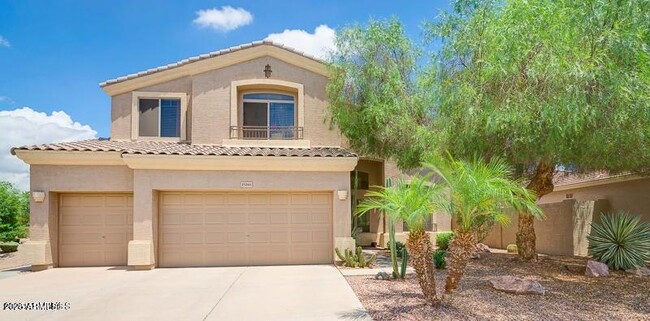
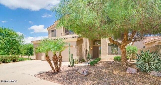
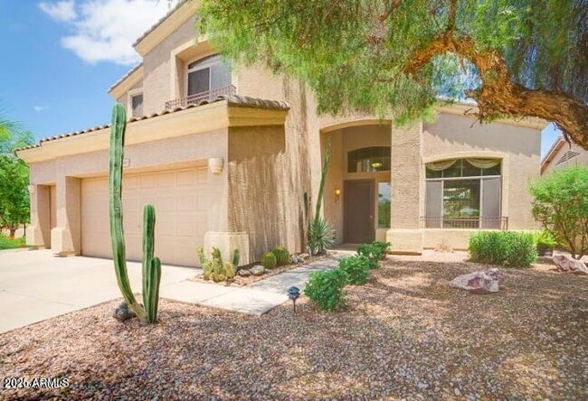
1580 W Saragosa St
Chandler, AZ 85224
Today
Favorites
602-820-9594
-
Bedrooms
4
-
Bathrooms
3
-
Square Feet
3,010 sq ft
-
Available
Available Now
Highlights
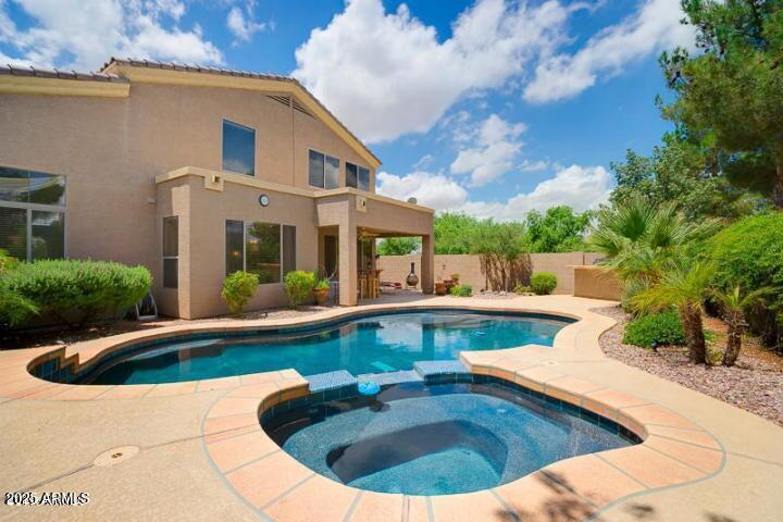
- Private Pool
- Spa
- Corner Lot
- Cul-De-Sac
- Tile Flooring
- Built-In Barbecue
1580 W Saragosa St

Favorites
About This Home
$3,395 deposit,
Available Now
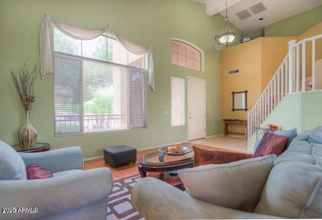
Location,location. Conveniently located behind Conley Elementary School,walking distance to Chandler Regional Hospital,minutes away from Chandler Fashion Center and Freeway access. Resort style living at its best. Gorgeous backyard is a tropical oasis with pebble tec pool and heated spa,waterfall,built in BBQ,and mature landscaping. This super home features a huge great room w/ plenty of space for pool table,bar,or library,and you still have formal living/dining rooms. Granite counter in kitchen and all bathrooms. New flooring in the bathrooms. Greenbelt to the side & no neighbors across street means privacy
1580 W Saragosa St is a house located in Maricopa County and the 85224 ZIP Code. This area is served by the Chandler Unified District attendance zone.
* Price shown is base rent and may not include non-optional fees and utilities.
Price, availability, fees, and any applicable rent special are subject to change without notice.
* Square footage definitions vary. Displayed square footage is approximate.
Home Details
Year Built
Built in 1998
Bedrooms and Bathrooms
3 Bathrooms
4 Bedrooms
Bathtub With Separate Shower Stall
Flooring
Tile
Carpet
Laminate
Home Design
Tile Roof
Stucco
Wood Frame Construction
Interior Spaces
3,010 Sq Ft Home
2-Story Property
Kitchen
Built-In Microwave
Laundry
Washer Hookup
Listing and Financial Details
Property Available on 6/19/25
$65 Move-In Fee
12-Month Minimum Lease Term
$65 Application Fee
Tax Lot 291
Assessor Parcel Number 303-75-427
Lot Details
6,874 Sq Ft Lot
Desert faces the front and back of the property
Corner Lot
Cul-De-Sac
Outdoor Features
Built-In Barbecue
Parking
3 Car Garage
Pool
Private Pool
Spa
Schools
Dr Howard K Conley Elementary School
John M Andersen Jr High Middle School
Hamilton High School
Utilities
Central Air
Heating System Uses Natural Gas
Community Details
Overview
Property has a Home Owners Association
Blakeman Association, Phone Number (602) 820-9591
Built by MORRISON
Blakeman Ranch Subdivision
Contact
- Listed by Dong Zhong | HomeSmart
- Phone Number
- Contact
-
Source
Arizona Regional MLS
Copyright 2025 Arizona Regional MLS. All rights reserved. Information is deemed reliable but not guaranteed.
Location
Get Directions
Fashionistas that live in the North Chandler area will appreciate the close proximity to Chandler Fashion Center. This mall has a varied selection of stores, which range from affordable to high-end. When it comes to groceries, residents have their choice of international supermarkets, or can opt for the organic Whole Foods Market.
If golf is your passion, then you’ll love tee time at San Marcos Golf Course. The neighborhood and surrounding area is encompassed with parks, including Arrowhead Meadows Park and Brooks Crossing Park – all great for outdoor recreational activities. The Perch Brewery is an excellent place for local craft beer as well as birdwatching. This North Chandler pub has more than forty beers on tap, and is the home of over fifty exotic rescue birds. Looking for something yummy to eat? Be sure to try Bella Gusto Urban Pizzeria, Elvira’s Belizean Café, Filiberto’s Mexican Food, Nishikawa Ramen, and Pho Viet Nam.
Learn more about living in North Chandler
Education
| Colleges & Universities | Distance | ||
|---|---|---|---|
| Colleges & Universities | Distance | ||
| Drive: | 10 min | 4.9 mi | |
| Drive: | 11 min | 6.0 mi | |
| Drive: | 15 min | 7.5 mi | |
| Drive: | 16 min | 7.5 mi |
1580 W Saragosa St is within 10 minutes or 4.9 miles from Chandler-Gilbert C.C., Pecos. It is also near Chandler-Gilbert CC. Sun Lakes and Alverno College.
Schools


Public Elementary School
Grades PK-6
681 Students
Attendance Zone
Public Middle School
Grades 6-8
728 Students
Attendance Zone
Public Middle & High School
Grades 8-12
3,850 Students
Attendance Zone
Private Elementary, Middle & High School
Grades K-12
205 Students
Nearby
School data provided by
 The GreatSchools Rating helps parents compare schools within a state based on a variety of school quality indicators and provides a helpful picture of how effectively each school serves all of its students. Ratings are on a scale of 1 (below average) to 10 (above average) and can include test scores, college readiness, academic progress, advanced courses, equity, discipline and attendance data. We also advise parents to visit schools, consider other information on school performance and programs, and consider family needs as part of the school selection process.
View GreatSchools Rating Methodology
Data provided by GreatSchools.org © 2025. All rights reserved.
View GreatSchools Rating Methodology
Data provided by GreatSchools.org © 2025. All rights reserved.
Transportation options available in Chandler include Alma School/Main St, located 9.0 miles from 1580 W Saragosa St. 1580 W Saragosa St is near Phoenix-Mesa Gateway, located 13.4 miles or 21 minutes away, and Phoenix Sky Harbor International, located 18.1 miles or 27 minutes away.
| Transit / Subway | Distance | ||
|---|---|---|---|
| Transit / Subway | Distance | ||
|
|
Drive: | 17 min | 9.0 mi |
|
|
Drive: | 18 min | 10.0 mi |
|
|
Drive: | 15 min | 10.1 mi |
|
|
Drive: | 16 min | 10.5 mi |
|
|
Drive: | 17 min | 11.2 mi |
| Commuter Rail | Distance | ||
|---|---|---|---|
| Commuter Rail | Distance | ||
|
|
Drive: | 31 min | 22.8 mi |
| Airports | Distance | ||
|---|---|---|---|
| Airports | Distance | ||
|
Phoenix-Mesa Gateway
|
Drive: | 21 min | 13.4 mi |
|
Phoenix Sky Harbor International
|
Drive: | 27 min | 18.1 mi |
Time and distance from 1580 W Saragosa St.
| Shopping Centers | Distance | ||
|---|---|---|---|
| Shopping Centers | Distance | ||
| Walk: | 16 min | 0.8 mi | |
| Drive: | 3 min | 1.4 mi | |
| Drive: | 4 min | 1.7 mi |
1580 W Saragosa St has 3 shopping centers within 1.7 miles, which is about a 4-minute walk. The miles and minutes will be for the farthest away property.
| Parks and Recreation | Distance | ||
|---|---|---|---|
| Parks and Recreation | Distance | ||
|
Pecos Park
|
Drive: | 16 min | 8.3 mi |
|
City of Chandler Environmental Education Center
|
Drive: | 15 min | 9.5 mi |
|
i.d.e.a. Museum
|
Drive: | 18 min | 10.2 mi |
|
Arizona Museum of Natural History
|
Drive: | 19 min | 10.5 mi |
|
South Mountain Park
|
Drive: | 22 min | 13.5 mi |
1580 W Saragosa St has 5 parks within 13.5 miles, including Pecos Park, City of Chandler Environmental Education Center, and i.d.e.a. Museum.
| Hospitals | Distance | ||
|---|---|---|---|
| Hospitals | Distance | ||
| Walk: | 12 min | 0.7 mi | |
| Drive: | 9 min | 4.3 mi | |
| Drive: | 8 min | 4.4 mi |
1580 W Saragosa St has 3 hospitals within 4.4 miles, the nearest is Chandler Regional Medical Center which is 0.7 mile away and a 12 minute walk.
| Military Bases | Distance | ||
|---|---|---|---|
| Military Bases | Distance | ||
| Drive: | 28 min | 19.0 mi | |
| Drive: | 57 min | 43.5 mi | |
| Drive: | 100 min | 81.6 mi |
1580 W Saragosa St has 3 military bases within 81.6 miles, the nearest is Phoenix Sky Harbor Airport Air Guard Station which is 19.0 miles away and a 28 minute drive.
You May Also Like
Similar Rentals Nearby
-
-

-
-
-
-
1 / 25

-

-

-

-


What Are Walk Score®, Transit Score®, and Bike Score® Ratings?
Walk Score® measures the walkability of any address. Transit Score® measures access to public transit. Bike Score® measures the bikeability of any address.
What is a Sound Score Rating?
A Sound Score Rating aggregates noise caused by vehicle traffic, airplane traffic and local sources

1580 W Saragosa St
Chandler, AZ 85224