

$1,550
/ Month
15300 Shirley Ave
Maple Heights, OH 44137
Favorites
15300 Shirley Ave

Favorites
Check Back Soon for Upcoming Availability
| Beds | Baths | Average SF |
|---|---|---|
| 4 Bedrooms 4 Bedrooms 4 Br | 1.5 Baths 1.5 Baths 1.5 Ba | 1,178 SF |
About This Property
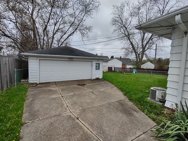
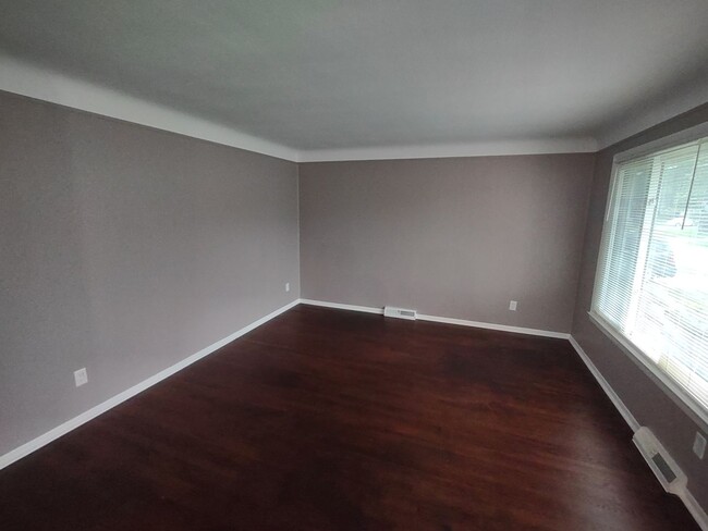
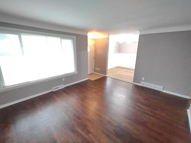
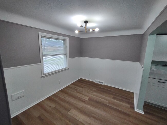
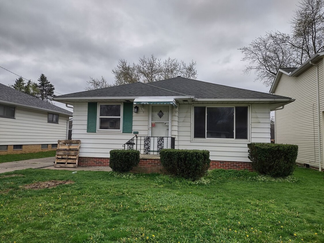
Welcome to this charming 4 bedroom, 1.5 bathroom home located in Maple Heights, OH. This cozy house features a full basement, perfect for storage or additional living space. The beautiful hardwood flooring throughout adds a touch of elegance to the home. With a 2 car garage, you'll have plenty of space for parking and storage. Don't miss out on the opportunity to make this house your new home! Requirements: - Income 2.5x the rent. - No evictions or felonies within the last 5 years. For inquiries, text or call the leasing agent at .
15300 Shirley Ave is a house located in Cuyahoga County and the 44137 ZIP Code. This area is served by the Maple Heights City School District attendance zone.
15300 Shirley Ave,
Maple Heights,
OH
44137
Maple Heights is a suburb of Cleveland in Cuyahoga County, Ohio, sitting less than ten miles from downtown Cleveland. The city has a population of around 22,840 residents spread across just six square miles, making it a close-knit community with easy access to one of Ohio's largest cities. If you are searching for apartments for rent in Maple Heights, you will find a mix of rental options including garden-style apartment communities, walk-up buildings, single-family rental homes, and townhomes, many set along tree-lined residential streets that give the city a settled, neighborhood feel. The Southgate USA shopping center, one of the earliest large shopping centers of its kind when it opened in 1955, is part of the city's retail history and continues to anchor commercial activity in the area.
Renters in Maple Heights enjoy convenient access to everyday needs, with shopping centers, local restaurants, and neighborhood taverns throughout the city.
Learn more about living in Maple Heights
Education
| Colleges & Universities | Distance | ||
|---|---|---|---|
| Colleges & Universities | Distance | ||
| Drive: | 16 min | 7.2 mi | |
| Drive: | 15 min | 7.6 mi | |
| Drive: | 20 min | 9.4 mi | |
| Drive: | 23 min | 10.1 mi |
15300 Shirley Ave is within 16 minutes or 7.2 miles from Cuyahoga C.C., East. It is also near Cuyahoga C.C., Eastern Campus and John Carroll University.
Schools


Public Elementary School
Grades K-5
467 Students
Nearby
Public Elementary School
Grades K-5
444 Students
Attendance Zone
Public Elementary School
Grades PK-5
470 Students
Attendance Zone
Public Middle School
Grades 6-8
637 Students
Attendance Zone
Public High School
Grades 9-12
868 Students
Attendance Zone
Private Elementary & Middle School
Grades K-8
178 Students
Nearby
Private Elementary, Middle & High School
Grades K-12
18 Students
Nearby
Private Elementary & Middle School
Grades K-8
128 Students
Nearby
Private High School
Grades 9-12
320 Students
Nearby
School data provided by
 The GreatSchools Rating helps parents compare schools within a state based on a variety of school quality indicators and provides a helpful picture of how effectively each school serves all of its students. Ratings are on a scale of 1 (below average) to 10 (above average) and can include test scores, college readiness, academic progress, advanced courses, equity, discipline and attendance data. We also advise parents to visit schools, consider other information on school performance and programs, and consider family needs as part of the school selection process.
View GreatSchools Rating Methodology
Data provided by GreatSchools.org © 2026. All rights reserved.
View GreatSchools Rating Methodology
Data provided by GreatSchools.org © 2026. All rights reserved.
Transportation options available in Maple Heights include Lee (Blue Line), located 6.1 miles from 15300 Shirley Ave. 15300 Shirley Ave is near Cleveland-Hopkins International, located 16.8 miles or 29 minutes away, and Akron-Canton Regional, located 39.0 miles or 53 minutes away.
| Transit / Subway | Distance | ||
|---|---|---|---|
| Transit / Subway | Distance | ||
|
|
Drive: | 14 min | 6.1 mi |
|
|
Drive: | 14 min | 6.4 mi |
|
|
Drive: | 15 min | 6.5 mi |
|
|
Drive: | 15 min | 6.6 mi |
|
|
Drive: | 15 min | 7.6 mi |
| Commuter Rail | Distance | ||
|---|---|---|---|
| Commuter Rail | Distance | ||
| Drive: | 7 min | 3.1 mi | |
| Drive: | 9 min | 3.6 mi | |
| Drive: | 20 min | 8.0 mi | |
|
Boston Mill
|
Drive: | 26 min | 11.1 mi |
|
|
Drive: | 26 min | 13.2 mi |
| Airports | Distance | ||
|---|---|---|---|
| Airports | Distance | ||
|
Cleveland-Hopkins International
|
Drive: | 29 min | 16.8 mi |
|
Akron-Canton Regional
|
Drive: | 53 min | 39.0 mi |
Walkability Near 15300 Shirley Ave Maple Heights, OH 44137
Getting Around
 What do Walkability, Transit, Drivability, and Bikeability mean?
Walkability measures the walking distance to day-to-day needs.
Transit measures access to public transportation.
Drivability measures congestion, parking availability, and access to major roads.
Bikeability measures the suitability for cycling.
How It Works
What do Walkability, Transit, Drivability, and Bikeability mean?
Walkability measures the walking distance to day-to-day needs.
Transit measures access to public transportation.
Drivability measures congestion, parking availability, and access to major roads.
Bikeability measures the suitability for cycling.
How It Works
Fairly Walkable
Walkability
40
/ 100
Limited Public Transit
Transit
30
/ 100
Very Drivable
Drivability
80
/ 100
Fairly Bikeable
Bikeability
50
/ 100
Scores provided by
-
Soundscore™
-
/ 100
Traffic
-Airport
-Businesses
-Scores provided by
HowLoud What is a Sound Score Rating? A Sound Score Rating aggregates noise caused by vehicle traffic, airplane traffic and local sources. How It WorksTime and distance from 15300 Shirley Ave.
| Shopping Centers | Distance | ||
|---|---|---|---|
| Shopping Centers | Distance | ||
| Walk: | 4 min | 0.2 mi | |
| Drive: | 4 min | 1.4 mi | |
| Drive: | 6 min | 2.4 mi |
15300 Shirley Ave has 3 shopping centers within 2.4 miles, which is about a 6-minute drive. The miles and minutes will be for the farthest away property.
| Parks and Recreation | Distance | ||
|---|---|---|---|
| Parks and Recreation | Distance | ||
|
Bedford Reservation
|
Drive: | 6 min | 2.7 mi |
|
Garfield Park Nature Center
|
Drive: | 10 min | 4.2 mi |
|
CanalWay Center
|
Drive: | 16 min | 6.9 mi |
|
Ohio & Erie Canal Reservation
|
Drive: | 14 min | 7.1 mi |
|
Nature Center at Shaker Lakes
|
Drive: | 17 min | 7.5 mi |
15300 Shirley Ave has 5 parks within 7.5 miles, including Bedford Reservation, Garfield Park Nature Center, and CanalWay Center.
| Hospitals | Distance | ||
|---|---|---|---|
| Hospitals | Distance | ||
| Drive: | 7 min | 3.1 mi | |
| Drive: | 9 min | 4.1 mi | |
| Drive: | 12 min | 5.7 mi |
15300 Shirley Ave has 3 hospitals within 5.7 miles, the nearest is Marymount Hospital which is 3.1 miles away and a 7 minute drive.
| Military Bases | Distance | ||
|---|---|---|---|
| Military Bases | Distance | ||
| Drive: | 98 min | 80.7 mi |
15300 Shirley Ave is 80.7 miles and a 98 minute drive from Mansfield Lahm Airport Air Guard Station.
You May Also Like
Similar Rentals Nearby


What Are Walk Score®, Transit Score®, and Bike Score® Ratings?
Walk Score® measures the walkability of any address. Transit Score® measures access to public transit. Bike Score® measures the bikeability of any address.
What is a Sound Score Rating?
A Sound Score Rating aggregates noise caused by vehicle traffic, airplane traffic and local sources.
15300 Shirley Ave
Maple Heights, OH 44137