
$2,200
Total Monthly Price
1 Month Lease
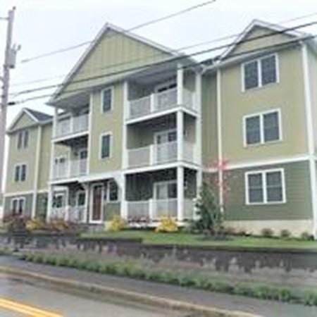
153 Sumner St
Quincy, MA 02169
2 Weeks Ago
|
Edit
Favorites
153 Sumner St

Favorites
Check Back Soon for Upcoming Availability
| Beds | Baths | Average SF |
|---|---|---|
| 2 Bedrooms 2 Bedrooms 2 Br | 1 Bath 1 Bath 1 Ba | 832 SF |
About This Property
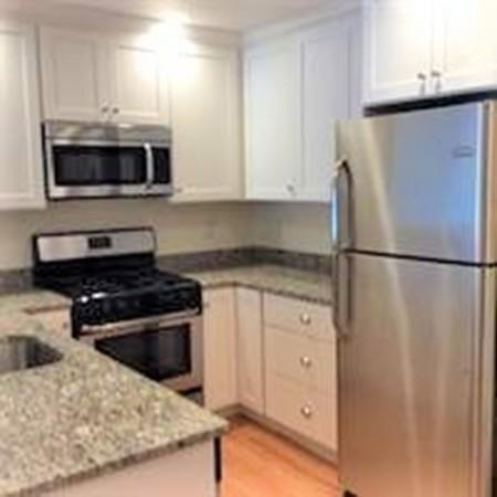
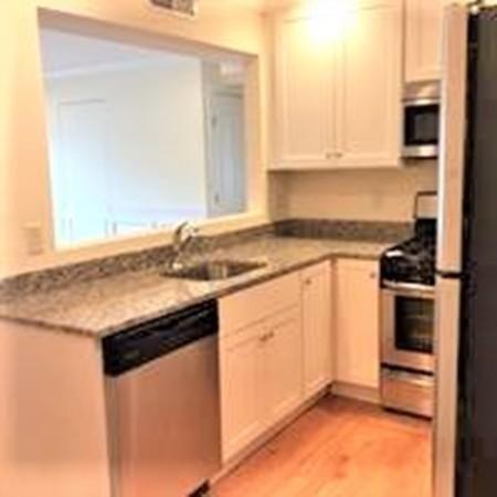
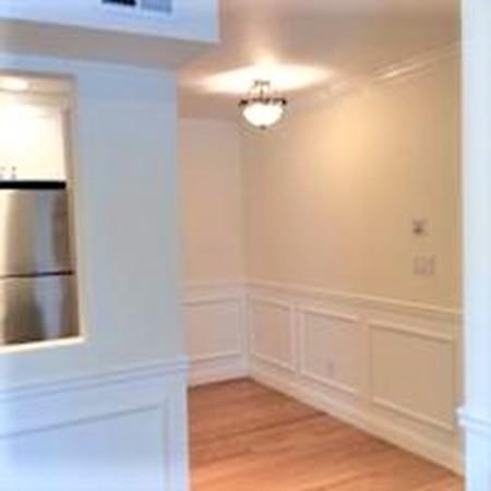
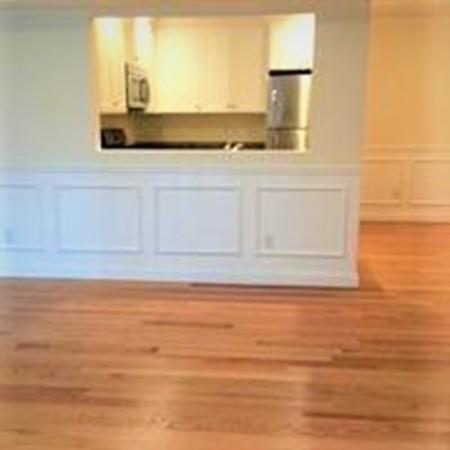
Available August 1st! Built in 2013, this beautifully appointed condo features hardwood floors, stainless steel appliances, granite, and the convenience of in unit laundry. Located near public transportation and the Quincy Center restaurant scene, it is all set for you to move in and enjoy the air conditioned comfort. With a balcony for entertaining, two assigned parking spaces and extra storage, this unit is a rare find. ONE small pet allowed. Verifiable income, excellent references and credit are a must.
153 Sumner St is a condo located in Norfolk County and the 02169 ZIP Code. This area is served by the Quincy School District attendance zone.
153 Sumner St,
Quincy,
MA
02169
Rich history and urban convenience meld together to form the coastal community of Quincy Point. Located about eleven miles outside of Boston, Quincy Point sits just east of Quincy Center (which is the “Point”) between Town River Bay and Weymouth Fore. Originally the site of a naval shipyard, the area attracted shipbuilders, fisherman, and even aviation pilots, forming a truly military-oriented community.
Though residents have a solid connection to Boston, they still very much display a strong and independent sense of identity. In addition to their Quincy Point apartments, locals share the love of the community beaches like Avalon. The popular Wollaston Beach, just two miles away, provides more than two miles of shoreline, a jogging and biking trail, and the Moswetuset Hummock National Historic Site. The United States Naval Shipbuilding Museum is housed at the shipyard, a cool and fun-filled family outing. Another great destination, Faxon Park, is about a mile from Quincy Point.
Learn more about living in Quincy PointBelow are rent ranges for similar nearby apartments
Education
| Colleges & Universities | Distance | ||
|---|---|---|---|
| Colleges & Universities | Distance | ||
| Drive: | 15 min | 6.9 mi | |
| Drive: | 19 min | 8.1 mi | |
| Drive: | 17 min | 9.3 mi | |
| Drive: | 19 min | 9.7 mi |
153 Sumner St is within 15 minutes or 6.9 miles from UMass Boston. It is also near Curry College and Massasoit C.C., Canton Campus.
Schools

Public Elementary School
Grades PK-5
Nearby
Public Elementary & Middle School
Grades PK-8
Attendance Zone
Public Elementary School
Grades K-5
Attendance Zone
Public High School
Grades 9-12
Attendance Zone
Private Elementary & Middle School
Grades PK-8
Nearby
Private Middle & High School
Grades 6-12
Nearby
School data provided by
 The GreatSchools Rating helps parents compare schools within a state based on a variety of school quality indicators and provides a helpful picture of how effectively each school serves all of its students. Ratings are on a scale of 1 (below average) to 10 (above average) and can include test scores, college readiness, academic progress, advanced courses, equity, discipline and attendance data. We also advise parents to visit schools, consider other information on school performance and programs, and consider family needs as part of the school selection process.
View GreatSchools Rating Methodology
Data provided by GreatSchools.org © 2026. All rights reserved.
View GreatSchools Rating Methodology
Data provided by GreatSchools.org © 2026. All rights reserved.
Transportation options available in Quincy include Wollaston Station, located 2.4 miles from 153 Sumner St. 153 Sumner St is near General Edward Lawrence Logan International, located 12.2 miles or 23 minutes away.
| Transit / Subway | Distance | ||
|---|---|---|---|
| Transit / Subway | Distance | ||
|
|
Drive: | 5 min | 2.4 mi |
|
|
Drive: | 5 min | 2.4 mi |
|
|
Drive: | 7 min | 3.4 mi |
|
|
Drive: | 9 min | 4.1 mi |
|
|
Drive: | 11 min | 5.5 mi |
| Commuter Rail | Distance | ||
|---|---|---|---|
| Commuter Rail | Distance | ||
|
|
Drive: | 2 min | 1.2 mi |
| Drive: | 6 min | 2.6 mi | |
|
|
Drive: | 8 min | 3.8 mi |
|
|
Drive: | 11 min | 4.9 mi |
|
|
Drive: | 11 min | 5.4 mi |
| Airports | Distance | ||
|---|---|---|---|
| Airports | Distance | ||
|
General Edward Lawrence Logan International
|
Drive: | 23 min | 12.2 mi |
Walkability Near 153 Sumner St Quincy, MA 02169
Getting Around
 What do Walkability, Transit, Drivability, and Bikeability mean?
Walkability measures the walking distance to day-to-day needs.
Transit measures access to public transportation.
Drivability measures congestion, parking availability, and access to major roads.
Bikeability measures the suitability for cycling.
How It Works
What do Walkability, Transit, Drivability, and Bikeability mean?
Walkability measures the walking distance to day-to-day needs.
Transit measures access to public transportation.
Drivability measures congestion, parking availability, and access to major roads.
Bikeability measures the suitability for cycling.
How It Works
Moderately Walkable
Walkability
70
/ 100
Some Public Transit
Transit
40
/ 100
Moderately Drivable
Drivability
60
/ 100
Fairly Bikeable
Bikeability
50
/ 100
Scores provided by
-
Soundscore™
-
/ 100
Traffic
-Airport
-Businesses
-Scores provided by
HowLoud What is a Sound Score Rating? A Sound Score Rating aggregates noise caused by vehicle traffic, airplane traffic and local sources. How It WorksTime and distance from 153 Sumner St.
| Shopping Centers | Distance | ||
|---|---|---|---|
| Shopping Centers | Distance | ||
| Walk: | 10 min | 0.5 mi | |
| Walk: | 14 min | 0.7 mi | |
| Walk: | 17 min | 0.9 mi |
153 Sumner St has 3 shopping centers within 0.9 mile, which is about a 17-minute walk. The miles and minutes will be for the farthest away property.
| Parks and Recreation | Distance | ||
|---|---|---|---|
| Parks and Recreation | Distance | ||
|
Adams National Historical Park
|
Drive: | 3 min | 1.7 mi |
|
Webb Memorial State Park
|
Drive: | 9 min | 4.1 mi |
|
Squantum Point Park
|
Drive: | 12 min | 5.2 mi |
|
Dorchester Shores Reservation
|
Drive: | 14 min | 6.8 mi |
|
Fort Revere
|
Drive: | 24 min | 12.7 mi |
153 Sumner St has 5 parks within 12.7 miles, including Adams National Historical Park, Webb Memorial State Park, and Squantum Point Park.
| Hospitals | Distance | ||
|---|---|---|---|
| Hospitals | Distance | ||
| Drive: | 11 min | 5.5 mi | |
| Drive: | 11 min | 5.6 mi | |
| Drive: | 11 min | 6.0 mi |
153 Sumner St has 3 hospitals within 6.0 miles, the nearest is Beth Israel Deaconess Hospital - Milton which is 5.5 miles away and a 11 minute drive.
You May Also Like
Similar Rentals Nearby


What Are Walk Score®, Transit Score®, and Bike Score® Ratings?
Walk Score® measures the walkability of any address. Transit Score® measures access to public transit. Bike Score® measures the bikeability of any address.
What is a Sound Score Rating?
A Sound Score Rating aggregates noise caused by vehicle traffic, airplane traffic and local sources.

153 Sumner St
Quincy, MA 02169