
$18,900
/ Month
15215 FRIENDS St
PACIFIC PALISADES, CA 90272
2 Weeks Ago
|
Edit
Favorites
15215 FRIENDS St

Favorites
Check Back Soon for Upcoming Availability
| Beds | Baths | Average SF |
|---|---|---|
| 3 Bedrooms 3 Bedrooms 3 Br | 3 Baths 3 Baths 3 Ba | 2,020 SF |
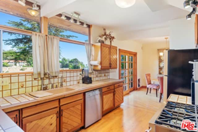
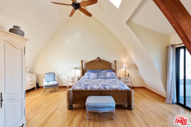
About This Property
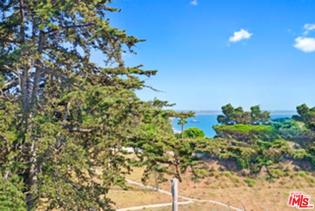
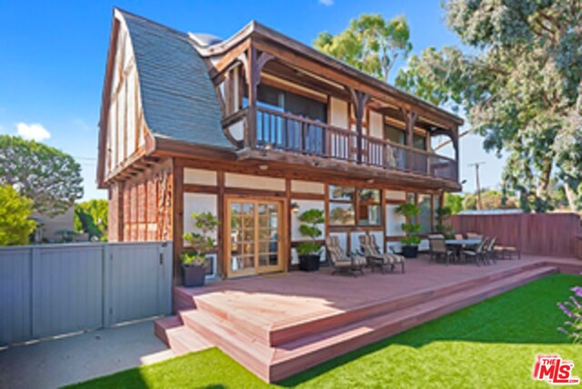
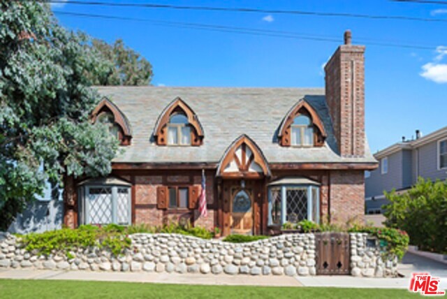
Escape to this beautiful cottage by the sea! This cottage has it all! It is located in a private setting right next to Portero Canyon Park and has an old-world charm at its best! It is situated on the rim with views from the master balcony and with a magnificent backyard of the ocean. It will warm your heart as you wake up to the ocean breeze and enjoy the quiet walks in Canyon Park.It is just four houses down to Via De Las Olas with unobstructed views of the ocean and a short drive to Palisades Village with world-class shopping and restaurants! Please call for a private showing!
15215 FRIENDS St is a house located in Los Angeles County and the 90272 ZIP Code. This area is served by the Los Angeles Unified attendance zone.
House Features
Air Conditioning
Washer/Dryer Hookup
Hardwood Floors
Fireplace
- Washer/Dryer Hookup
- Air Conditioning
- Fireplace
- Hardwood Floors
- Carpet
- Dining Room
- Views
Location
Get Directions
From mountain hikes to beach volleyball, everything you've heard about Pacific Palisades is true -- it is gorgeous, filled with outdoor adventures, and is home to some of California's most beautiful stretches of beach. Situated directly north of Santa Monica and just 16 miles west of Downtown Los Angeles, it's easy to see why this is the playground for movie stars and celebrities. Cruise along the Pacific Coast Highway to Sunset Beach, play volleyball at Will Rogers State Beach, or go bicycling along the ocean at Marvin Braude Bike Trail.
On days you'd rather be hiking than surfing, Temescal Canyon State Park, Rivas Canyon Park, and Will Rogers State Historic Park are all on the east side of Pacific Palisades. Palisades Park features a rec center, a playground, ball fields, and picnic areas. Topanga State Park features 36 miles of hiking trails. While Pacific Palisades is primarily a residential area, Sunset Boulevard is home to several shops, restaurants, and other businesses.
Learn more about living in Pacific Palisades
Amenities
- Washer/Dryer Hookup
- Air Conditioning
- Fireplace
- Hardwood Floors
- Carpet
- Dining Room
- Views
Education
| Colleges & Universities | Distance | ||
|---|---|---|---|
| Colleges & Universities | Distance | ||
| Drive: | 11 min | 4.2 mi | |
| Drive: | 13 min | 4.9 mi | |
| Drive: | 14 min | 6.0 mi | |
| Drive: | 14 min | 6.7 mi |
15215 FRIENDS St is within 11 minutes or 4.2 miles from Santa Monica Coll., Emeritus. It is also near Santa Monica College, Madison and Santa Monica Coll..
Schools


Public Elementary School
Grades K-5
611 Students
Nearby
Charter Elementary School
Grades K-5
428 Students
Attendance Zone
Charter Middle School
Grades 6-8
1,718 Students
Attendance Zone
Charter High School
Grades 9-12
2,959 Students
Attendance Zone
Private Elementary & Middle School
Grades PK-8
Nearby
Private Elementary & Middle School
Grades K-8
219 Students
Nearby
Private Elementary, Middle & High School
Grades 5-12
Nearby
School data provided by
 The GreatSchools Rating helps parents compare schools within a state based on a variety of school quality indicators and provides a helpful picture of how effectively each school serves all of its students. Ratings are on a scale of 1 (below average) to 10 (above average) and can include test scores, college readiness, academic progress, advanced courses, equity, discipline and attendance data. We also advise parents to visit schools, consider other information on school performance and programs, and consider family needs as part of the school selection process.
View GreatSchools Rating Methodology
Data provided by GreatSchools.org © 2025. All rights reserved.
View GreatSchools Rating Methodology
Data provided by GreatSchools.org © 2025. All rights reserved.
Transportation options available in PACIFIC PALISADES include Downtown Santa Monica, located 4.7 miles from 15215 FRIENDS St. 15215 FRIENDS St is near Los Angeles International, located 13.2 miles or 27 minutes away, and Bob Hope, located 22.3 miles or 39 minutes away.
| Transit / Subway | Distance | ||
|---|---|---|---|
| Transit / Subway | Distance | ||
|
|
Drive: | 12 min | 4.7 mi |
|
|
Drive: | 14 min | 6.0 mi |
|
|
Drive: | 15 min | 6.7 mi |
|
|
Drive: | 15 min | 7.6 mi |
| Drive: | 17 min | 8.5 mi |
| Commuter Rail | Distance | ||
|---|---|---|---|
| Commuter Rail | Distance | ||
|
|
Drive: | 33 min | 18.7 mi |
|
|
Drive: | 39 min | 22.3 mi |
|
|
Drive: | 39 min | 22.4 mi |
|
|
Drive: | 40 min | 22.4 mi |
| Drive: | 40 min | 23.2 mi |
| Airports | Distance | ||
|---|---|---|---|
| Airports | Distance | ||
|
Los Angeles International
|
Drive: | 27 min | 13.2 mi |
|
Bob Hope
|
Drive: | 39 min | 22.3 mi |
Time and distance from 15215 FRIENDS St.
| Shopping Centers | Distance | ||
|---|---|---|---|
| Shopping Centers | Distance | ||
| Drive: | 8 min | 3.3 mi | |
| Drive: | 11 min | 4.2 mi | |
| Drive: | 11 min | 4.6 mi |
15215 FRIENDS St has 3 shopping centers within 4.6 miles, which is about a 11-minute drive. The miles and minutes will be for the farthest away property.
| Parks and Recreation | Distance | ||
|---|---|---|---|
| Parks and Recreation | Distance | ||
|
Temescal Gateway Park
|
Drive: | 4 min | 1.3 mi |
|
Will Rogers State Beach
|
Drive: | 5 min | 2.2 mi |
|
Will Rogers State Historic Park
|
Drive: | 9 min | 3.0 mi |
|
Santa Monica State Beach
|
Drive: | 10 min | 4.0 mi |
|
Santa Monica Pier Aquarium
|
Drive: | 11 min | 4.7 mi |
15215 FRIENDS St has 5 parks within 4.7 miles, including Temescal Gateway Park, Will Rogers State Beach, and Will Rogers State Historic Park.
| Hospitals | Distance | ||
|---|---|---|---|
| Hospitals | Distance | ||
| Drive: | 13 min | 5.1 mi | |
| Drive: | 14 min | 6.6 mi | |
| Drive: | 21 min | 11.1 mi |
15215 FRIENDS St has 3 hospitals within 11.1 miles, the nearest is Santa Monica - UCLA Medical Center & Orthopaedic Hospital which is 5.1 miles away and a 13 minute drive.
| Military Bases | Distance | ||
|---|---|---|---|
| Military Bases | Distance | ||
| Drive: | 28 min | 18.6 mi |
15215 FRIENDS St is 18.6 miles and a 28 minute drive from Los Angeles Air Force Base.
You May Also Like
Similar Rentals Nearby


What Are Walk Score®, Transit Score®, and Bike Score® Ratings?
Walk Score® measures the walkability of any address. Transit Score® measures access to public transit. Bike Score® measures the bikeability of any address.
What is a Sound Score Rating?
A Sound Score Rating aggregates noise caused by vehicle traffic, airplane traffic and local sources

15215 FRIENDS St
PACIFIC PALISADES, CA 90272