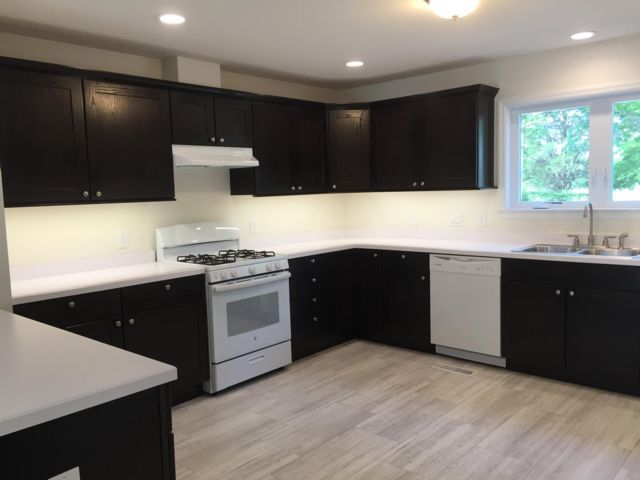
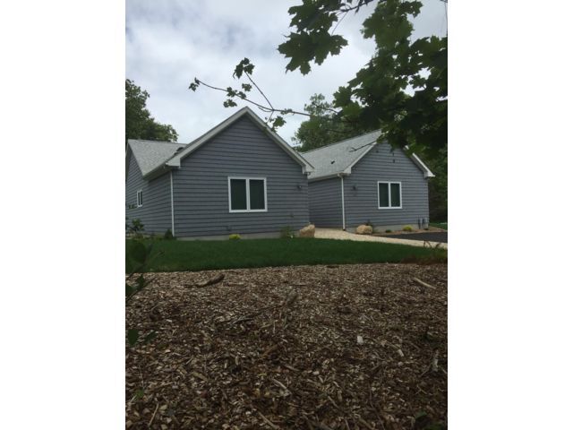
$1,044 / Month

146 N Ferry Rd

,

Shelter Island Heights, NY 11965

Share Listing
Favorites
146 N Ferry Rd
Share Listing
Favorites

Check Back Soon for Upcoming Availability

Beds Baths Average SF
1 Bedroom 1 Bedroom 1 Br 1 Bath 1 Bath 1 Ba

About This Property

SHELTER ISLAND-Year Round RentalShared house with 4BR and 4Baths. Your Private room is large and spacious with double wide closet, room for King bed, end tables, desk, couch and oversized bathroom with tub/shower, linen closet, carpeted and individual cable line. There is CAC, propane heat, washer and dryer, massive kitchen with dishwasher, propane stove and refrigerator. Designed to be affordable with high value insulation. Full and dry basement to store personal belongings. Parking on premises. $1,044 per month plus electric, propane and lawn care. Pet allowed. Available April 1. Call 631-374-9745 to arrange an appointment. (Listing 6951363 Confirmed 4/8/2020)

146 N Ferry Rd is a house located in Suffolk County and the 11965 ZIP Code. This area is served by the Shelter Island Union Free School District attendance zone.

Location
146 N Ferry Rd, Shelter Island Heights,
NY 11965
Get Directions
| Edit

Under 30 minutes

Commute Time is calculated at rush hour.
Education
Colleges & Universities Distance
Drive: 64 min 28.6 mi
Drive: 129 min 31.0 mi
Drive: 138 min 34.8 mi
Drive: 188 min 77.3 mi
146 N Ferry Rd is within 64 minutes or 28.6 miles from SUNY Suffolk Co., Eastern. It is also near Connecticut College and University of Connecticut.
Schools
Public Elementary, Middle & High School
Grades PK-12
183 Students
Attendance Zone
Private Elementary School
Grades PK-5
92 Students
Nearby
Transportation

146 N Ferry Rd is near Tweed/New Haven, located 74.3 miles or 185 minutes away.

Commuter Rail Distance
Drive: 19 min 2.3 mi
Drive: 26 min 6.6 mi
Drive: 39 min 12.0 mi
Drive: 42 min 14.0 mi
Drive: 38 min 14.8 mi
Airports Distance
Airports Distance
Tweed/New Haven
Drive: 185 min 74.3 mi

Walkability Near 146 N Ferry Rd Shelter Island Heights, NY 11965

Getting Around
Somewhat Walkable
Walkability
20 / 100
Minimal Public Transit
Transit
0 / 100
Exceptionally Drivable
Drivability
90 / 100
Somewhat Bikeable
Bikeability
30 / 100

Scores provided by

What do Walkability, Transit, Drivability, and Bikeability mean? Walkability measures the walking distance to day-to-day needs. Transit measures access to public transportation. Drivability measures congestion, parking availability, and access to major roads. Bikeability measures the suitability for cycling. How It Works
-
Soundscore
- / 100

Traffic

-

Airport

-

Businesses

-

Scores provided by

HowLoud What is a Sound Score Rating? A Sound Score Rating aggregates noise caused by vehicle traffic, airplane traffic and local sources. How It Works
Points of Interest

Time and distance from 146 N Ferry Rd.

Shopping Centers Distance
Drive: 26 min 6.6 mi
Drive: 27 min 7.2 mi
146 N Ferry Rd has 3 shopping centers within 7.2 miles, which is about a 27-minute drive. The miles and minutes will be for the farthest away property.
Parks and Recreation Distance
East End Seaport Maritime Museum
Drive: 18 min 2.2 mi
Red House Nature Center
Drive: 22 min 3.6 mi
Custer Institute Observatory
Drive: 29 min 7.7 mi
Orient Beach State Park
Drive: 45 min 12.9 mi
Cedar Point County Park
Drive: 53 min 15.2 mi
146 N Ferry Rd has 5 parks within 15.2 miles, including East End Seaport Maritime Museum, Red House Nature Center, and Custer Institute Observatory.
Hospitals Distance
Hospitals Distance
Drive: 20 min 2.9 mi
146 N Ferry Rd is 2.9 miles and a 20 minute drive from Stony Brook Eastern Long Island Hospital.
Military Bases Distance
Drive: 130 min 30.6 mi
Drive: 68 min 32.7 mi
Drive: 138 min 34.5 mi
146 N Ferry Rd has 3 military bases within 34.5 miles, the nearest is Fort Trumbell US Navy which is 30.6 miles away and a 130 minute drive.

You May Also Like

Similar Rentals Nearby