
$4,495 / Month
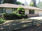
1450 McKenzie Ave
Los Altos, CA 94024
2 Weeks Ago
Favorites
1450 McKenzie Ave

Favorites
Check Back Soon for Upcoming Availability
| Beds | Baths | Average SF |
|---|---|---|
| 3 Bedrooms 3 Bedrooms 3 Br | 2 Baths 2 Baths 2 Ba | 1,381 SF |
About This Property
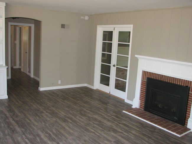
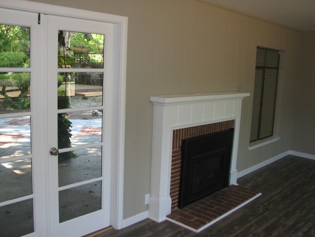
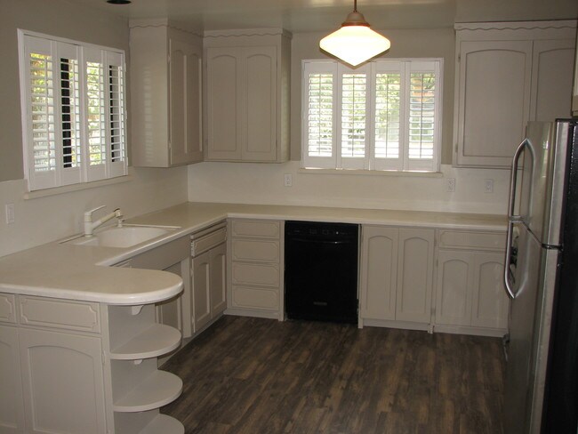
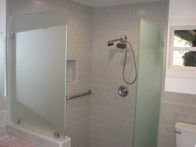
3BR / 2Ba 1381 Sq ft available October 10th A Must See! Make this 3 bedroom 2 bath 1,381 sq ft family home yours! Enjoy living in this warm tree lined sought after Los Altos neighborhood while having having easy access to the heart of Silicon Valley, 4 miles from Apple, 7 miles from Google, 7 miles to Yahoo and only 13 miles from FaceBook! Close to shopping, restaurants HWY 280, HWY 85 and Foothill Exp. Nearby schools are exceptional and include Oak Avenue Elementary, Georgina P Blach Junior High, and Mountain View High. Home Offers: -Spacious living room -Recessed lighting -Ceiling fans -Cozy gas fireplace -Central heating -Corian countertops in kitchen -Stainless Steel Refrigerator -Breakfast nook -Spacious laundry room with utility sink -Large handicap-accessible bathroom -Whole house fan -Lots of storage -W/d hookups -Attached 500 sf two-car garage French doors open up to an exceptionally large private back yard ideal for entertaining. Large corner lot measures up at over 15,600 square feet! Owner pays gardener and garbage. Please email Chris at Chris@managementrentz.com to request a VIDEO TOUR https://my.virtualeyesmedia.com/tour/1450-mckenzie-ave-los-altos-ca-94024
1450 McKenzie Ave is a house located in Santa Clara County and the 94024 ZIP Code. This area is served by the Los Altos Elementary attendance zone.
Location
Get Directions
Los Altos likes to strike a balance between the urbanized atmosphere of the Bay Area and the more rural environment of the wide-open spaces bordering the city’s southwest side. While it is mainly a residential community, the downtown area surrounding Main Street is a walkable shopping and dining district with tree-lined streets and several public parks nearby. The crime rate is quite low and the local schools are among the highest-performing in the state. Palo Alto is right next door and San Jose just a few minutes down the road, giving Los Altos residents convenient access to Silicon Valley’s greatest amenities.
Learn more about living in Los AltosBelow are rent ranges for similar nearby apartments
Education
| Colleges & Universities | Distance | ||
|---|---|---|---|
| Colleges & Universities | Distance | ||
| Drive: | 9 min | 3.7 mi | |
| Drive: | 10 min | 4.4 mi | |
| Drive: | 14 min | 6.1 mi | |
| Drive: | 17 min | 8.0 mi |
1450 McKenzie Ave is within 9 minutes or 3.7 miles from Foothill Coll., Los Altos. It is also near De Anza College and Foothill College, Middlefield.
Schools

Public Elementary School
Grades K-5
367 Students
Nearby
Public Elementary School
Grades K-6
332 Students
Attendance Zone
Public Middle School
Grades 7-8
416 Students
Attendance Zone
Public High School
Grades 9-12
2,220 Students
Attendance Zone
Private Elementary & Middle School
Grades PK-8
114 Students
Nearby
Private High School
Grades 9-12
1,776 Students
Nearby
School data provided by
 The GreatSchools Rating helps parents compare schools within a state based on a variety of school quality indicators and provides a helpful picture of how effectively each school serves all of its students. Ratings are on a scale of 1 (below average) to 10 (above average) and can include test scores, college readiness, academic progress, advanced courses, equity, discipline and attendance data. We also advise parents to visit schools, consider other information on school performance and programs, and consider family needs as part of the school selection process.
View GreatSchools Rating Methodology
Data provided by GreatSchools.org © 2025. All rights reserved.
View GreatSchools Rating Methodology
Data provided by GreatSchools.org © 2025. All rights reserved.
Transportation options available in Los Altos include Mountain View Station, located 3.1 miles from 1450 McKenzie Ave. 1450 McKenzie Ave is near Norman Y Mineta San Jose International, located 11.4 miles or 19 minutes away, and San Francisco International, located 28.5 miles or 39 minutes away.
| Transit / Subway | Distance | ||
|---|---|---|---|
| Transit / Subway | Distance | ||
| Drive: | 8 min | 3.1 mi | |
|
|
Drive: | 8 min | 3.1 mi |
| Drive: | 9 min | 3.6 mi | |
| Drive: | 9 min | 3.7 mi | |
| Drive: | 9 min | 3.9 mi |
| Commuter Rail | Distance | ||
|---|---|---|---|
| Commuter Rail | Distance | ||
| Drive: | 8 min | 3.1 mi | |
| Drive: | 9 min | 3.2 mi | |
| Drive: | 12 min | 5.1 mi | |
| Drive: | 10 min | 5.1 mi | |
| Drive: | 15 min | 6.9 mi |
| Airports | Distance | ||
|---|---|---|---|
| Airports | Distance | ||
|
Norman Y Mineta San Jose International
|
Drive: | 19 min | 11.4 mi |
|
San Francisco International
|
Drive: | 39 min | 28.5 mi |
Time and distance from 1450 McKenzie Ave.
| Shopping Centers | Distance | ||
|---|---|---|---|
| Shopping Centers | Distance | ||
| Walk: | 20 min | 1.1 mi | |
| Drive: | 4 min | 1.3 mi | |
| Drive: | 5 min | 1.8 mi |
1450 McKenzie Ave has 3 shopping centers within 1.8 miles, which is about a 5-minute walk. The miles and minutes will be for the farthest away property.
| Parks and Recreation | Distance | ||
|---|---|---|---|
| Parks and Recreation | Distance | ||
|
Redwood Grove
|
Drive: | 8 min | 3.1 mi |
|
Deer Hollow Farm
|
Drive: | 9 min | 3.7 mi |
|
Rancho San Antonio County Park
|
Drive: | 10 min | 3.9 mi |
|
Foothill College Observatory
|
Drive: | 9 min | 3.9 mi |
|
Rancho San Antonio Open Space Preserve
|
Drive: | 11 min | 4.0 mi |
1450 McKenzie Ave has 5 parks within 4.0 miles, including Deer Hollow Farm, Redwood Grove, and Rancho San Antonio County Park.
| Hospitals | Distance | ||
|---|---|---|---|
| Hospitals | Distance | ||
| Drive: | 4 min | 1.3 mi | |
| Drive: | 13 min | 6.2 mi | |
| Drive: | 13 min | 7.0 mi |
1450 McKenzie Ave has 3 hospitals within 7.0 miles, the nearest is El Camino Hospital which is 1.3 miles away and a 4 minute drive.
| Military Bases | Distance | ||
|---|---|---|---|
| Military Bases | Distance | ||
| Drive: | 13 min | 5.5 mi |
1450 McKenzie Ave is 5.5 miles and a 13 minute drive from Ames Research Center.
You May Also Like
Similar Rentals Nearby


What Are Walk Score®, Transit Score®, and Bike Score® Ratings?
Walk Score® measures the walkability of any address. Transit Score® measures access to public transit. Bike Score® measures the bikeability of any address.
What is a Sound Score Rating?
A Sound Score Rating aggregates noise caused by vehicle traffic, airplane traffic and local sources

1450 McKenzie Ave
Los Altos, CA 94024