

$2,800 / Month
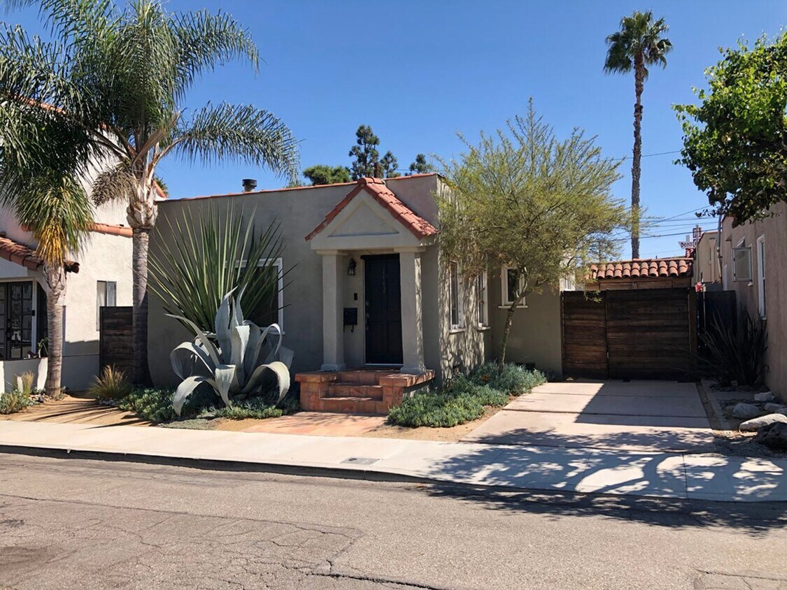
1442 Anaheim Pl
Long Beach, CA 90804
2 Weeks Ago
Favorites
1442 Anaheim Pl

Favorites
Check Back Soon for Upcoming Availability
| Beds | Baths | Average SF |
|---|---|---|
| 2 Bedrooms 2 Bedrooms 2 Br | 1 Bath 1 Bath 1 Ba | 878 SF |
About This Property
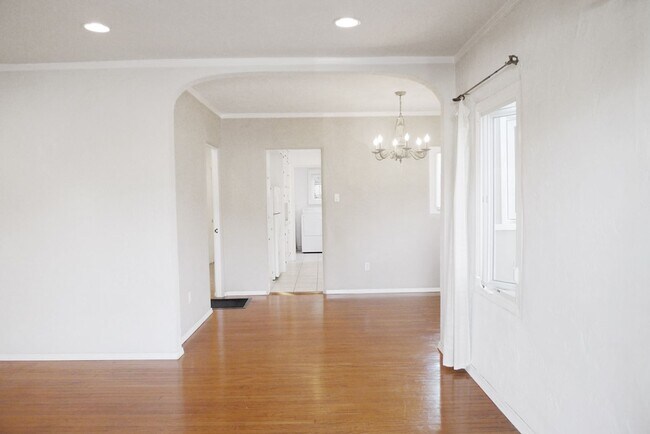
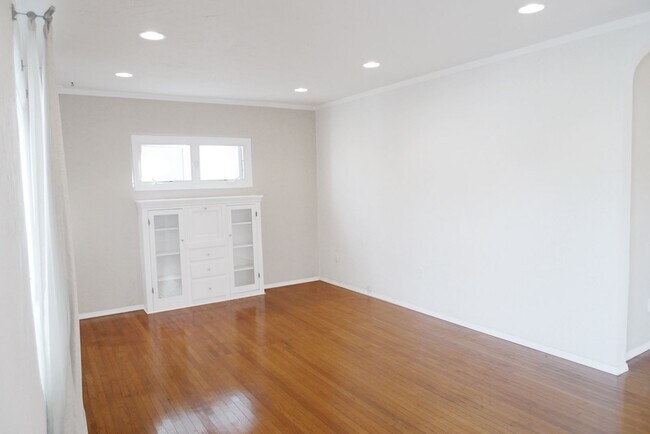
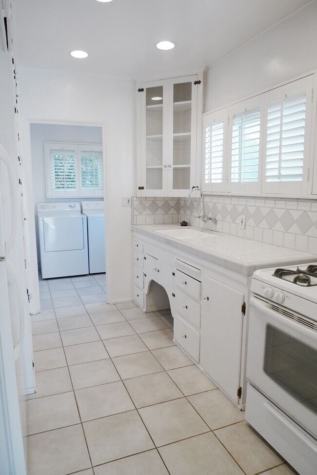
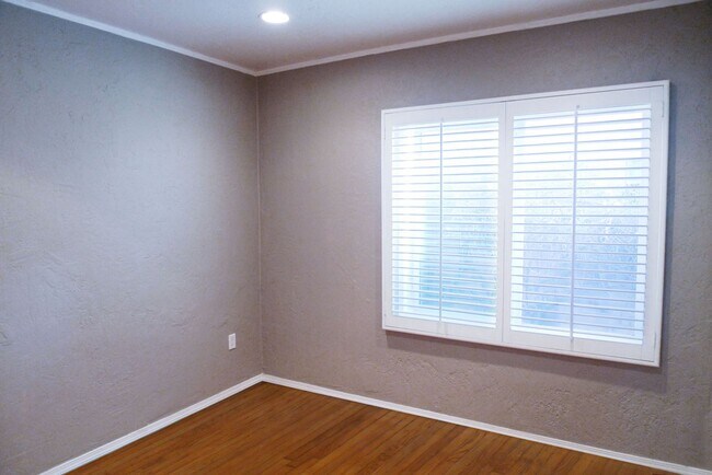
Coming Soon! Classic Spanish style with all of the charm! Description: *Gorgeous 2bd 1ba House * Original wood floors * New vinyl windows * Recessed lighting throughout * New interior paint * Kitchen has plenty of old world charm cabinets * New stainless steel fridge included * Laundry room includes washer & dryer hookups and original built-in ironing board * Private garage and backyard Close to 405, 605, 710 Freeways. Biking distance to Belmont Shore beach, 2nd Street shops, restaurants, coffee shop, gym, and entertainment area. Bike or walk to Cal State Long Beach, Wilson High school, Joe Rogers field, Blair field, recreation park, and golf course. Call or text Matt to view today! * Pets considered with proof of landlord insurance, $500 pet fee per pet, $50/mo pet rent per pet, & approved application **No Fish tanks or liquid filled furniture allowed.
1442 Anaheim Pl is a house located in Los Angeles County and the 90804 ZIP Code. This area is served by the Long Beach Unified attendance zone.
Location
Get Directions
The area defined as Eastside Long Beach puts you just two blocks from the white-sand beaches along the Pacific Ocean, two miles from Downtown Long Beach, and only 25 minutes from the heart of Los Angeles. You'll also be within easy reach of California State University-Long Beach, which is adjacent to the neighborhood. Eastside is just east of Alamitos Avenue with the Pacific Coast Highway forming the northern border. Recreation Park is on the neighborhood's southeast side. There’s a plethora of coastal rentals in a variety of styles here, ensuring you’ll find your perfect fit in one of SoCal’s most vibrant areas.
Learn more about living in Eastside Long BeachBelow are rent ranges for similar nearby apartments
| Beds | Average Size | Lowest | Typical | Premium |
|---|---|---|---|---|
| Studio Studio Studio | 446 Sq Ft | $1,395 | $1,755 | $2,100 |
| 1 Bed 1 Bed 1 Bed | 701-704 Sq Ft | $1,179 | $1,867 | $2,650 |
| 2 Beds 2 Beds 2 Beds | 904-906 Sq Ft | $1,650 | $2,825 | $4,250 |
| 3 Beds 3 Beds 3 Beds | 1672 Sq Ft | $2,151 | $4,377 | $11,000 |
| 4 Beds 4 Beds 4 Beds | 3042 Sq Ft | $4,375 | $5,674 | $5,999 |
Education
| Colleges & Universities | Distance | ||
|---|---|---|---|
| Colleges & Universities | Distance | ||
| Drive: | 4 min | 1.6 mi | |
| Drive: | 7 min | 2.7 mi | |
| Drive: | 8 min | 3.6 mi | |
| Drive: | 17 min | 9.4 mi |
1442 Anaheim Pl is within 4 minutes or 1.6 miles from Cal State Long Beach. It is also near Long Beach City Coll., Coast and Long Beach City Coll..
Schools


Public Elementary School
Grades K-6
603 Students
Nearby
Public Elementary School
Grades K-5
324 Students
Attendance Zone
Public Middle School
Grades 6-8
997 Students
Attendance Zone
Public High School
Grades 9-12
3,515 Students
Attendance Zone
Private Elementary School
Grades PK-6
Nearby
Private Elementary, Middle & High School
Grades K-12
37 Students
Nearby
School data provided by
 The GreatSchools Rating helps parents compare schools within a state based on a variety of school quality indicators and provides a helpful picture of how effectively each school serves all of its students. Ratings are on a scale of 1 (below average) to 10 (above average) and can include test scores, college readiness, academic progress, advanced courses, equity, discipline and attendance data. We also advise parents to visit schools, consider other information on school performance and programs, and consider family needs as part of the school selection process.
View GreatSchools Rating Methodology
Data provided by GreatSchools.org © 2025. All rights reserved.
View GreatSchools Rating Methodology
Data provided by GreatSchools.org © 2025. All rights reserved.
Transportation options available in Long Beach include Pacific Coast Highway Station, located 3.3 miles from 1442 Anaheim Pl. 1442 Anaheim Pl is near Long Beach (Daugherty Field), located 4.3 miles or 7 minutes away, and John Wayne/Orange County, located 18.3 miles or 24 minutes away.
| Transit / Subway | Distance | ||
|---|---|---|---|
| Transit / Subway | Distance | ||
|
|
Drive: | 7 min | 3.3 mi |
|
|
Drive: | 8 min | 3.8 mi |
|
|
Drive: | 9 min | 4.0 mi |
|
|
Drive: | 10 min | 4.3 mi |
|
|
Drive: | 10 min | 4.4 mi |
| Commuter Rail | Distance | ||
|---|---|---|---|
| Commuter Rail | Distance | ||
|
|
Drive: | 24 min | 14.1 mi |
|
|
Drive: | 22 min | 15.8 mi |
|
|
Drive: | 28 min | 17.5 mi |
| Drive: | 25 min | 17.8 mi | |
|
|
Drive: | 27 min | 19.6 mi |
| Airports | Distance | ||
|---|---|---|---|
| Airports | Distance | ||
|
Long Beach (Daugherty Field)
|
Drive: | 7 min | 4.3 mi |
|
John Wayne/Orange County
|
Drive: | 24 min | 18.3 mi |
Time and distance from 1442 Anaheim Pl.
| Shopping Centers | Distance | ||
|---|---|---|---|
| Shopping Centers | Distance | ||
| Walk: | 4 min | 0.2 mi | |
| Walk: | 8 min | 0.4 mi | |
| Walk: | 8 min | 0.5 mi |
1442 Anaheim Pl has 3 shopping centers within 0.5 mile, which is about a 8-minute walk. The miles and minutes will be for the farthest away property.
| Parks and Recreation | Distance | ||
|---|---|---|---|
| Parks and Recreation | Distance | ||
|
Colorado Lagoon
|
Drive: | 3 min | 1.6 mi |
|
Earl Burns Miller Japanese Garden
|
Drive: | 3 min | 1.8 mi |
|
Los Cerritos Wetlands Trust
|
Drive: | 5 min | 3.2 mi |
|
El Dorado Nature Center
|
Drive: | 6 min | 3.6 mi |
|
El Dorado East Regional Park
|
Drive: | 8 min | 3.7 mi |
1442 Anaheim Pl has 5 parks within 3.7 miles, including Colorado Lagoon, Earl Burns Miller Japanese Garden, and Los Cerritos Wetlands Trust.
| Hospitals | Distance | ||
|---|---|---|---|
| Hospitals | Distance | ||
| Drive: | 3 min | 2.0 mi | |
| Drive: | 8 min | 3.5 mi | |
| Drive: | 7 min | 4.1 mi |
1442 Anaheim Pl has 3 hospitals within 4.1 miles, the nearest is Ocean View Psychiatric Health Facility which is 2.0 miles away and a 3 minute drive.
| Military Bases | Distance | ||
|---|---|---|---|
| Military Bases | Distance | ||
| Drive: | 14 min | 8.2 mi | |
| Drive: | 24 min | 11.1 mi |
1442 Anaheim Pl is 8.2 miles from Los Alamitos Army Airfield, and is convenient to other military bases, including Long Beach Naval Station.
You May Also Like
Similar Rentals Nearby


What Are Walk Score®, Transit Score®, and Bike Score® Ratings?
Walk Score® measures the walkability of any address. Transit Score® measures access to public transit. Bike Score® measures the bikeability of any address.
What is a Sound Score Rating?
A Sound Score Rating aggregates noise caused by vehicle traffic, airplane traffic and local sources
1442 Anaheim Pl
Long Beach, CA 90804