
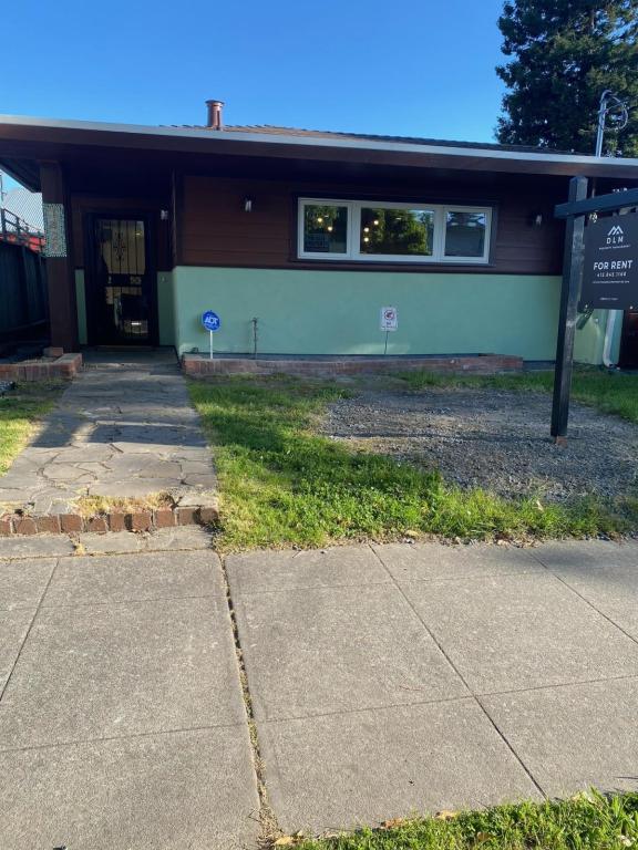
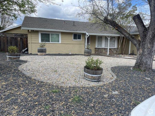
$4,500 / Month
1420 66th St
Berkeley, CA 94702
2 Weeks Ago
Favorites
1420 66th St

Favorites
Check Back Soon for Upcoming Availability
| Beds | Baths | Average SF |
|---|---|---|
| 3 Bedrooms 3 Bedrooms 3 Br | 1 Bath 1 Bath 1 Ba | 1,241 SF |
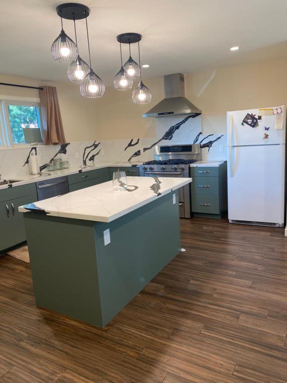
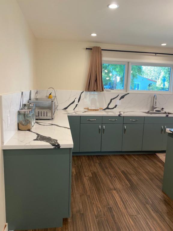
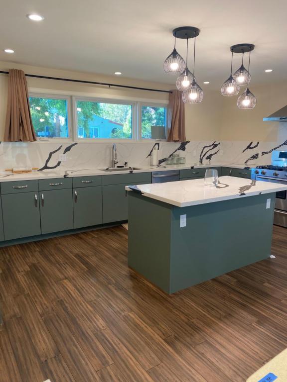
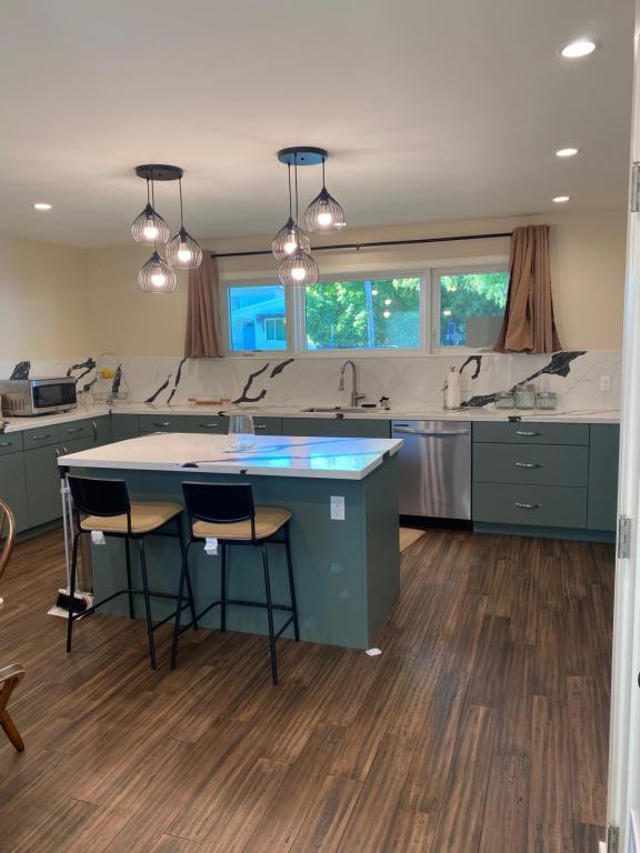
About This Property
Discover the ideal blend of comfort and convenience in this charming 3-bedroom, 1-bathroom house in Berkeley. Updated kitchen and bathroom elevate your living experience while dedicated driveway parking ensures hassle-free arrivals. Enjoy easy access to shopping, dining, and the I-80 highway, making commuting a breeze. Don't miss out on this perfect opportunity to enjoy Berkeley living with amenities at your fingertips!
1420 66th St is a house located in Alameda County and the 94702 ZIP Code. This area is served by the Berkeley Unified attendance zone.
Location
Get Directions
Southwest Berkeley is bounded by University Avenue to the north, Sacramento Street to the East, Alcatraz Avenue to the south and the San Francisco Bay to the west. Southwest Berkeley comprises a fascinating mix of the educational and the industrial. Less dense than the more inland parts of Berkeley, Southwest Berkeley has a diverse mix of apartment and home rentals that will delight students and families alike. Convenient access to the illustrious university make this a great option for students and staff, but any renter will love the restaurant and retail options that make this walkable locale so convenient.
Learn more about living in Southwest BerkeleyBelow are rent ranges for similar nearby apartments
Education
| Colleges & Universities | Distance | ||
|---|---|---|---|
| Colleges & Universities | Distance | ||
| Drive: | 5 min | 2.0 mi | |
| Drive: | 7 min | 2.7 mi | |
| Drive: | 10 min | 3.3 mi | |
| Drive: | 8 min | 3.6 mi |
1420 66th St is within 5 minutes or 2.0 miles from Berkeley City College. It is also near Samuel Merritt University and UC Berkeley.
Schools


Public Elementary School
Grades K-5
459 Students
Attendance Zone
Public Elementary School
Grades K-5
370 Students
Attendance Zone
Public Elementary School
Grades K-5
270 Students
Nearby
Public Middle School
Grades 6-8
596 Students
Attendance Zone
Public High School
Grades 9-12
3,204 Students
Attendance Zone
Private Elementary School
Grades PK-5
Nearby
Private Elementary School
Grades K-6
57 Students
Nearby
Private Elementary & Middle School
Grades PK-8
440 Students
Nearby
Private Elementary, Middle & High School
Grades K-12
Nearby
School data provided by
 The GreatSchools Rating helps parents compare schools within a state based on a variety of school quality indicators and provides a helpful picture of how effectively each school serves all of its students. Ratings are on a scale of 1 (below average) to 10 (above average) and can include test scores, college readiness, academic progress, advanced courses, equity, discipline and attendance data. We also advise parents to visit schools, consider other information on school performance and programs, and consider family needs as part of the school selection process.
View GreatSchools Rating Methodology
View GreatSchools Rating Methodology
Transportation options available in Berkeley include Ashby Station, located 0.6 mile from 1420 66th St. 1420 66th St is near Metro Oakland International, located 13.2 miles or 21 minutes away, and San Francisco International, located 22.9 miles or 36 minutes away.
| Transit / Subway | Distance | ||
|---|---|---|---|
| Transit / Subway | Distance | ||
|
|
Walk: | 12 min | 0.6 mi |
|
|
Drive: | 5 min | 1.9 mi |
|
|
Drive: | 6 min | 2.1 mi |
|
|
Drive: | 8 min | 2.5 mi |
|
|
Drive: | 7 min | 3.6 mi |
| Commuter Rail | Distance | ||
|---|---|---|---|
| Commuter Rail | Distance | ||
|
|
Drive: | 4 min | 1.3 mi |
|
|
Drive: | 6 min | 2.3 mi |
|
|
Drive: | 10 min | 4.4 mi |
| Drive: | 18 min | 10.5 mi | |
| Drive: | 20 min | 11.7 mi |
| Airports | Distance | ||
|---|---|---|---|
| Airports | Distance | ||
|
Metro Oakland International
|
Drive: | 21 min | 13.2 mi |
|
San Francisco International
|
Drive: | 36 min | 22.9 mi |
Time and distance from 1420 66th St.
| Shopping Centers | Distance | ||
|---|---|---|---|
| Shopping Centers | Distance | ||
| Drive: | 4 min | 1.5 mi | |
| Drive: | 4 min | 1.5 mi | |
| Drive: | 5 min | 1.6 mi |
1420 66th St has 3 shopping centers within 1.6 miles, which is about a 5-minute drive. The miles and minutes will be for the farthest away property.
| Parks and Recreation | Distance | ||
|---|---|---|---|
| Parks and Recreation | Distance | ||
|
Strawberry Creek Park
|
Drive: | 4 min | 1.6 mi |
|
San Francisco Bay Trail (at Emeryville)
|
Drive: | 4 min | 1.6 mi |
|
Willard Park
|
Drive: | 5 min | 1.8 mi |
|
Habitot Children's Museum
|
Drive: | 5 min | 1.9 mi |
|
People's Park
|
Drive: | 7 min | 2.2 mi |
1420 66th St has 5 parks within 2.2 miles, including Strawberry Creek Park, San Francisco Bay Trail (at Emeryville), and Willard Park.
| Hospitals | Distance | ||
|---|---|---|---|
| Hospitals | Distance | ||
| Drive: | 3 min | 1.3 mi | |
| Drive: | 4 min | 1.5 mi | |
| Drive: | 6 min | 2.6 mi |
1420 66th St has 3 hospitals within 2.6 miles, the nearest is Children's Hospital & Research Center Oakland which is 1.3 miles away and a 3 minute drive.
| Military Bases | Distance | ||
|---|---|---|---|
| Military Bases | Distance | ||
| Drive: | 15 min | 5.6 mi | |
| Drive: | 16 min | 7.1 mi |
1420 66th St is 5.6 miles from Oakland Army Base, and is convenient to other military bases, including Alameda/US Naval Air Station Alameda.
You May Also Like
Similar Rentals Nearby


What Are Walk Score®, Transit Score®, and Bike Score® Ratings?
Walk Score® measures the walkability of any address. Transit Score® measures access to public transit. Bike Score® measures the bikeability of any address.
What is a Sound Score Rating?
A Sound Score Rating aggregates noise caused by vehicle traffic, airplane traffic and local sources
1420 66th St
Berkeley, CA 94702