

$4,600 / Month
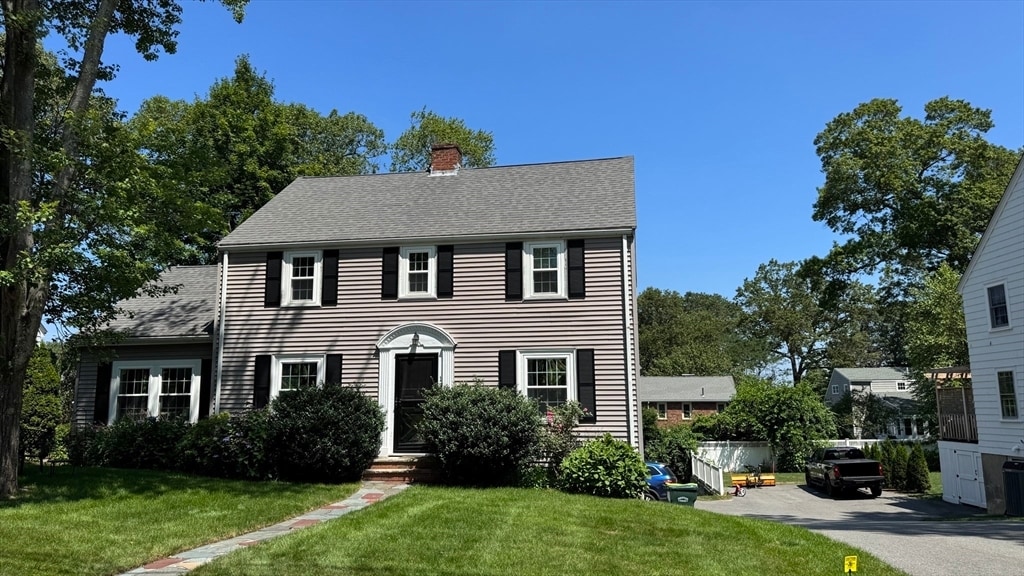
139 Laurel Dr
Needham, MA 02492
Today
Favorites
617-620-5493
-
Bedrooms
3
-
Bathrooms
1.5
-
Square Feet
1,846 sq ft
-
Available
Available Aug 23
Highlights
- Medical Services
- Landscaped Professionally
- Property is near public transit
- Community Pool
- Tennis Courts
- Jogging Path
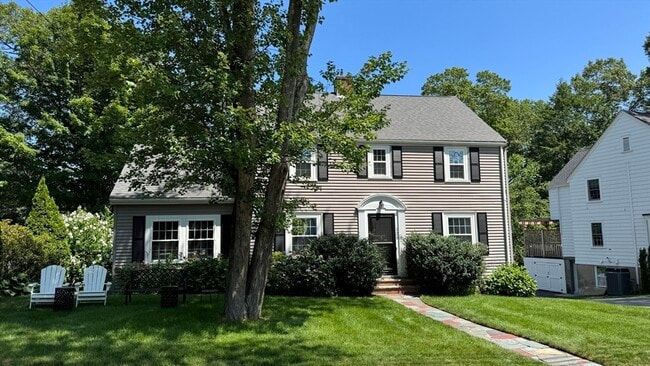
139 Laurel Dr

Favorites
About This Home
$4,600 deposit,
Available Aug 23
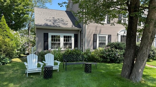
Still time to move in before the school year starts! This charming home is nestled in a sought-after enclave neighborhood in the Newman Elementary School district,just minutes from downtown Needham and the Needham Junction commuter rail. Offering 1,846 sq ft,3 spacious bedrooms,and 1.5 baths,this home blends classic comfort with modern updates. The remodeled kitchen features granite countertops and stainless steel appliances,perfect for home cooking and entertaining. Enjoy the generous,newer family room—ideal for movie nights and watching the big game. Numerous upgrades include newer windows,siding,roof,insulation,and a high-efficiency boiler,providing comfort and energy savings year-round. A fantastic opportunity to enjoy a great home in an unbeatable location! ***** The property is still being prep'd so not quite ready for showings yet,likely by Friday 8/1 ******* MLS# 73410771
139 Laurel Dr is a house located in Norfolk County and the 02492 ZIP Code. This area is served by the Needham attendance zone.
* Price shown is base rent and may not include non-optional fees and utilities.
Price, availability, fees, and any applicable rent special are subject to change without notice.
* Square footage definitions vary. Displayed square footage is approximate.
Home Details
Home Type
Single Family Detached Home
Year Built
Built in 1937
Accessible Home Design
Entry on the 11th floor
Bedrooms and Bathrooms
Bathtub with Shower
Primary bedroom located on second floor
Linen Closet In Bathroom
1.5 Bathrooms
3 Bedrooms
Interior Spaces
Ceramic Tile Flooring
1,846 Sq Ft Home
Kitchen
Range with Range Hood
Oven
Microwave
Dishwasher
Disposal
Laundry
Dryer
Laundry on main level
Washer
Listing and Financial Details
Security Deposit $4,600
Property Available on 8/23/25
Assessor Parcel Number M:037.0 B:0009 L:0000.0,138985
Rent includes occupancy only
Location
Property is near public transit
Property is near schools
Lot Details
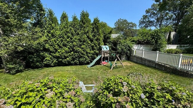
Landscaped Professionally
Garden
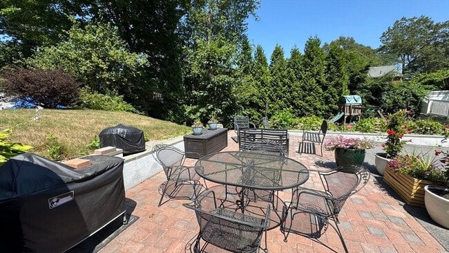
Outdoor Features
Patio
Parking
1 Car Garage
Schools
Newman Elementary School
Pollard Middle School
Needham High School
Utilities
No Cooling
Heating System Uses Natural Gas
Community Details
Amenities
Medical Services
Shops
Laundry Facilities
Overview
No Home Owners Association
Pet Policy
Call for details about the types of pets allowed
Recreation
Community Pool
Tennis Courts
Jogging Path
Park
Fees and Policies
The fees below are based on community-supplied data and may exclude additional fees and utilities.
Pet policies are negotiable.
Contact
- Listed by Preston Hall | Keller Williams Realty
- Phone Number
-
Source
 MLS Property Information Network
The property listing data and information set forth herein were provided to MLS Property Information Network, Inc. from third party sources, including sellers, lessors and public records, and were compiled by MLS Property Information Network, Inc. The property listing data and information are for the personal, non-commercial use of consumers having a good faith interest in purchasing or leasing listed properties of the type displayed to them and may not be used for any purpose other than to identify prospective properties which such consumers may have a good faith interest in purchasing or leasing. MLS Property Information Network, Inc. and its subscribers disclaim any and all representations and warranties as to the accuracy of the property listing data and information set forth herein. All properties are subject to prior sale, change or withdrawal. Copyright © 2025 MLS Property Information Network, Inc. All rights reserved.
Location
Get Directions
Amenities
- Dishwasher
- Disposal
- Microwave
- Range
- Refrigerator
- Patio
Just west of Boston and East of Worcester sits Metro West, a region that houses a group of towns and cities with significant historical backgrounds. A total of 19 municipalities make up the core of this community, but other municipalities are considered to be a part of the Interstate 495/Metro West Corridor.
Learn more about living in Metro West
Education
| Colleges & Universities | Distance | ||
|---|---|---|---|
| Colleges & Universities | Distance | ||
| Drive: | 7 min | 3.0 mi | |
| Drive: | 13 min | 5.4 mi | |
| Drive: | 15 min | 7.3 mi | |
| Drive: | 16 min | 7.7 mi |
139 Laurel Dr is within 7 minutes or 3.0 miles from Babson College. It is also near Wellesley College and Boston College.
Schools


Public Elementary School
Grades PK-5
699 Students
Attendance Zone
Public Elementary & Middle School
Grades 6
446 Students
Attendance Zone
Public Middle School
Grades 7-8
818 Students
Attendance Zone
Public Middle School
Grades 6-8
657 Students
Nearby
Public High School
Grades 9-12
1,645 Students
Attendance Zone
Private Elementary & Middle School
Grades PK-8
353 Students
Nearby
Private Elementary School
Grades K-3
141 Students
Nearby
Private Middle School
Grades 6-8
109 Students
Nearby
Private Middle & High School
Grades 7-12
378 Students
Nearby
School data provided by
 The GreatSchools Rating helps parents compare schools within a state based on a variety of school quality indicators and provides a helpful picture of how effectively each school serves all of its students. Ratings are on a scale of 1 (below average) to 10 (above average) and can include test scores, college readiness, academic progress, advanced courses, equity, discipline and attendance data. We also advise parents to visit schools, consider other information on school performance and programs, and consider family needs as part of the school selection process.
View GreatSchools Rating Methodology
Data provided by GreatSchools.org © 2025. All rights reserved.
View GreatSchools Rating Methodology
Data provided by GreatSchools.org © 2025. All rights reserved.
Transportation options available in Needham include Newton Highlands Station, located 4.4 miles from 139 Laurel Dr. 139 Laurel Dr is near General Edward Lawrence Logan International, located 17.6 miles or 32 minutes away, and Worcester Regional, located 36.3 miles or 63 minutes away.
| Transit / Subway | Distance | ||
|---|---|---|---|
| Transit / Subway | Distance | ||
|
|
Drive: | 9 min | 4.4 mi |
|
|
Drive: | 11 min | 4.6 mi |
|
|
Drive: | 11 min | 4.8 mi |
|
|
Drive: | 11 min | 5.4 mi |
|
|
Drive: | 12 min | 6.0 mi |
| Commuter Rail | Distance | ||
|---|---|---|---|
| Commuter Rail | Distance | ||
|
|
Walk: | 6 min | 0.4 mi |
|
|
Walk: | 17 min | 0.9 mi |
|
|
Drive: | 4 min | 1.8 mi |
|
|
Drive: | 5 min | 1.8 mi |
|
|
Drive: | 10 min | 4.5 mi |
| Airports | Distance | ||
|---|---|---|---|
| Airports | Distance | ||
|
General Edward Lawrence Logan International
|
Drive: | 32 min | 17.6 mi |
|
Worcester Regional
|
Drive: | 63 min | 36.3 mi |
Time and distance from 139 Laurel Dr.
| Shopping Centers | Distance | ||
|---|---|---|---|
| Shopping Centers | Distance | ||
| Walk: | 16 min | 0.9 mi | |
| Drive: | 6 min | 2.8 mi | |
| Drive: | 7 min | 3.0 mi |
139 Laurel Dr has 3 shopping centers within 3.0 miles, which is about a 7-minute walk. The miles and minutes will be for the farthest away property.
| Parks and Recreation | Distance | ||
|---|---|---|---|
| Parks and Recreation | Distance | ||
|
Cutler Park Reservation
|
Drive: | 7 min | 3.2 mi |
|
Hemlock Gorge Reservation
|
Drive: | 8 min | 3.6 mi |
|
Brook Farm Historic Site
|
Drive: | 11 min | 4.8 mi |
|
Horticultural Society at Elm Bank
|
Drive: | 13 min | 5.0 mi |
|
Elm Bank Reservation
|
Drive: | 16 min | 6.6 mi |
139 Laurel Dr has 5 parks within 6.6 miles, including Cutler Park Reservation, Hemlock Gorge Reservation, and Brook Farm Historic Site.
| Hospitals | Distance | ||
|---|---|---|---|
| Hospitals | Distance | ||
| Walk: | 14 min | 0.8 mi | |
| Drive: | 11 min | 5.5 mi | |
| Drive: | 11 min | 5.8 mi |
139 Laurel Dr has 3 hospitals within 5.8 miles, the nearest is Beth Israel Deaconess Hospital - Needham which is 0.8 mile away and a 14 minute walk.
| Military Bases | Distance | ||
|---|---|---|---|
| Military Bases | Distance | ||
| Drive: | 16 min | 8.0 mi | |
| Drive: | 28 min | 15.8 mi |
139 Laurel Dr is 8.0 miles from US Military Reservation, and is convenient to other military bases, including Hanscom Air Force Base.
You May Also Like
Similar Rentals Nearby


What Are Walk Score®, Transit Score®, and Bike Score® Ratings?
Walk Score® measures the walkability of any address. Transit Score® measures access to public transit. Bike Score® measures the bikeability of any address.
What is a Sound Score Rating?
A Sound Score Rating aggregates noise caused by vehicle traffic, airplane traffic and local sources
139 Laurel Dr
Needham, MA 02492