$2,150
Total Monthly Price
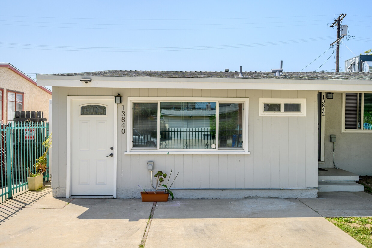
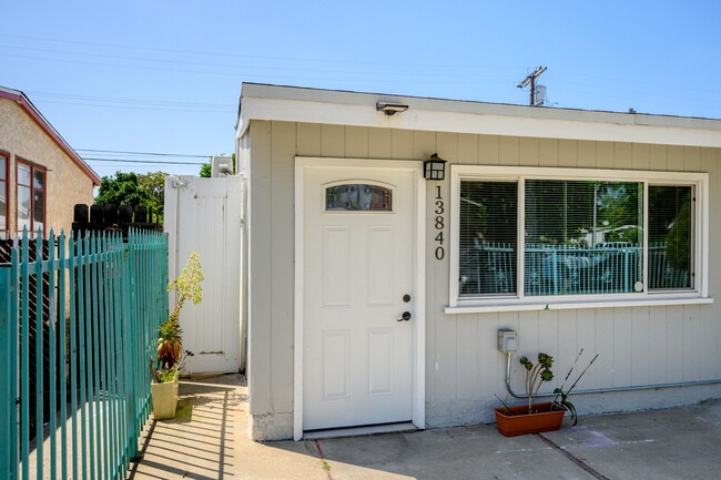
13840 Community St
Panorama City, CA 91402
Favorites
-
Bedrooms
1
-
Bathrooms
1
-
Square Feet
520 sq ft
-
Available
Available Now
Highlights
- Patio
- Walk-In Closets
- Gated
13840 Community St

Favorites
About This Home
12 Month Lease,
$2,150 deposit,
Available Now
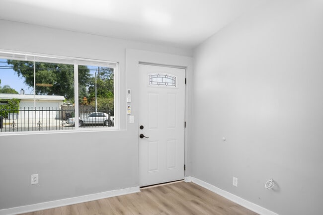
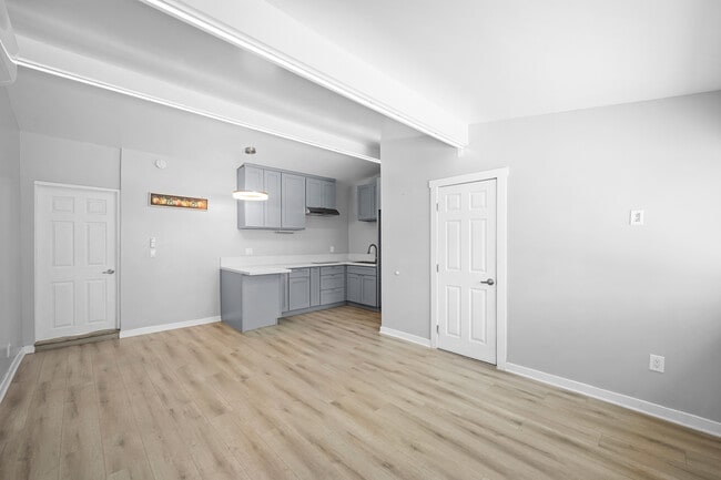
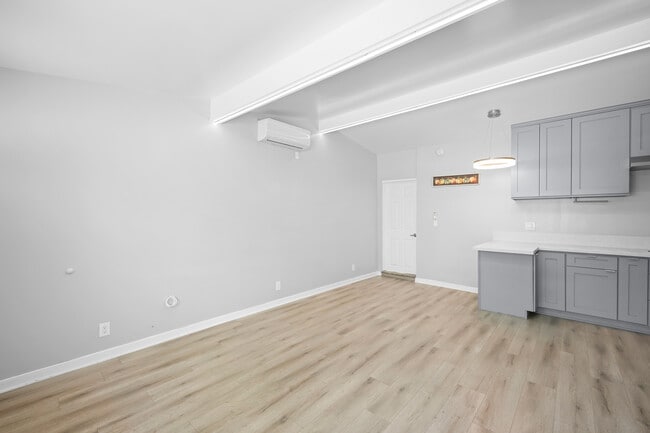
Updated ADU | 1 Bed/1Bath/ 520 Sqft | Gated | Recessed Lighting/LED Lights | Laminate Floors | Ductless A/C Units | Walk In Closet | Private/Covered Patio | Appliances Included: Electric Stovetop & Refrigerator | Washer & Dryer Hook-ups | 1 Car Driveway Parking | Gas is included in the rent | Tenant Pays Power & Trash Bill | Water Bill Is Split Between Tenants. 12 Month Lease then month to month. First months rent + Security Deposit Due upon signing. Renters Insurance is required.
13840 Community St is a house located in Los Angeles County and the 91402 ZIP Code. This area is served by the Los Angeles Unified Rocp School District attendance zone.
* Price shown is total price based on community-supplied monthly required fees. Excludes user-selected optional fees and variable or usage-based fees and required charges due at or prior to move-in or at move-out. Price, availability, fees, and any applicable rent special are subject to change without notice.
* Square footage definitions vary. Displayed square footage is approximate.
House Features
Air Conditioning
Washer/Dryer Hookup
Walk-In Closets
Refrigerator
- Washer/Dryer Hookup
- Air Conditioning
- Refrigerator
- Walk-In Closets
- Gated
- Patio
Contact
- Contact
Location
Get Directions
Panorama City sits at the heart of the San Fernando Valley as Los Angeles' first planned community, a distinction that dates back to 1948 when open farmland was reimagined into a post-World War II neighborhood built for everyday life. The area carries that original sense of purpose today, offering residents a self-contained corner of the Valley with schools, recreational centers, a senior center, and even an ice rink all within reach. Its location along Van Nuys Boulevard keeps the neighborhood connected to the broader Valley corridor, with downtown Los Angeles accessible via the 405 freeway.
The housing stock reflects Panorama City's layered history. Single-family homes with modest yards share blocks with low-rise apartment communities, making the neighborhood one of the most densely populated areas across the entire Valley.
Learn more about living in Panorama City
Education
| Colleges & Universities | Distance | ||
|---|---|---|---|
| Colleges & Universities | Distance | ||
| Drive: | 8 min | 4.2 mi | |
| Drive: | 13 min | 6.3 mi | |
| Drive: | 12 min | 7.0 mi | |
| Drive: | 15 min | 8.3 mi |
13840 Community St is within 8 minutes or 4.2 miles from Valley College. It is also near Woodbury University and Cal State Northridge.
Schools


Public Elementary School
Grades PK-5
218 Students
Nearby
Public Elementary School
Grades K-5
436 Students
Attendance Zone
Public Middle & High School
Grades 6-12
1,229 Students
Attendance Zone
Public High School
Grades 9-12
1,316 Students
Attendance Zone
Private Elementary School
Grades PK-5
Nearby
Private Elementary, Middle & High School
Grades K-12
982 Students
Nearby
Private Elementary School
Grades K-5
Nearby
School data provided by
 The GreatSchools Rating helps parents compare schools within a state based on a variety of school quality indicators and provides a helpful picture of how effectively each school serves all of its students. Ratings are on a scale of 1 (below average) to 10 (above average) and can include test scores, college readiness, academic progress, advanced courses, equity, discipline and attendance data. We also advise parents to visit schools, consider other information on school performance and programs, and consider family needs as part of the school selection process.
View GreatSchools Rating Methodology
Data provided by GreatSchools.org © 2026. All rights reserved.
View GreatSchools Rating Methodology
Data provided by GreatSchools.org © 2026. All rights reserved.
Transportation options available in Panorama City include North Hollywood Station, located 6.0 miles from 13840 Community St. 13840 Community St is near Bob Hope, located 5.5 miles or 10 minutes away, and Los Angeles International, located 24.2 miles or 35 minutes away.
| Transit / Subway | Distance | ||
|---|---|---|---|
| Transit / Subway | Distance | ||
|
|
Drive: | 9 min | 6.0 mi |
|
|
Drive: | 13 min | 8.3 mi |
|
|
Drive: | 17 min | 11.3 mi |
| Commuter Rail | Distance | ||
|---|---|---|---|
| Commuter Rail | Distance | ||
|
|
Drive: | 4 min | 1.7 mi |
|
|
Drive: | 8 min | 3.8 mi |
| Drive: | 10 min | 5.6 mi | |
|
|
Drive: | 11 min | 6.2 mi |
|
|
Drive: | 12 min | 6.4 mi |
| Airports | Distance | ||
|---|---|---|---|
| Airports | Distance | ||
|
Bob Hope
|
Drive: | 10 min | 5.5 mi |
|
Los Angeles International
|
Drive: | 35 min | 24.2 mi |
Getting Around
 What do Walkability, Transit, Drivability, and Bikeability mean?
Walkability measures the walking distance to day-to-day needs.
Transit measures access to public transportation.
Drivability measures congestion, parking availability, and access to major roads.
Bikeability measures the suitability for cycling.
How It Works
What do Walkability, Transit, Drivability, and Bikeability mean?
Walkability measures the walking distance to day-to-day needs.
Transit measures access to public transportation.
Drivability measures congestion, parking availability, and access to major roads.
Bikeability measures the suitability for cycling.
How It Works
Moderately Walkable
Walkability
70
/ 100
Some Public Transit
Transit
40
/ 100
Very Drivable
Drivability
80
/ 100
Fairly Bikeable
Bikeability
40
/ 100
Scores provided by
Active
Soundscore™
70
/ 100
Traffic
BusyAirport
CalmBusinesses
ActiveScores provided by
HowLoud What is a Sound Score Rating? A Sound Score Rating aggregates noise caused by vehicle traffic, airplane traffic and local sources. How It WorksTime and distance from 13840 Community St.
| Shopping Centers | Distance | ||
|---|---|---|---|
| Shopping Centers | Distance | ||
| Walk: | 3 min | 0.2 mi | |
| Walk: | 4 min | 0.2 mi |
13840 Community St has 2 shopping centers within 0.2 mile, which is about a 4-minute walk. The miles and minutes will be for the farthest away property.
| Parks and Recreation | Distance | ||
|---|---|---|---|
| Parks and Recreation | Distance | ||
|
Cal State Northridge Botanic Garden
|
Drive: | 12 min | 6.3 mi |
|
The Japanese Garden
|
Drive: | 11 min | 6.8 mi |
|
Lake Balboa
|
Drive: | 13 min | 7.2 mi |
|
Sepulveda Basin Wildlife Reserve
|
Drive: | 15 min | 7.3 mi |
|
Los Encinos State Historic Park
|
Drive: | 14 min | 8.0 mi |
13840 Community St has 5 parks within 8.0 miles, including The Japanese Garden, Cal State Northridge Botanic Garden, and Sepulveda Basin Wildlife Reserve.
| Hospitals | Distance | ||
|---|---|---|---|
| Hospitals | Distance | ||
| Walk: | 8 min | 0.4 mi | |
| Drive: | 3 min | 1.4 mi | |
| Drive: | 6 min | 3.3 mi |
13840 Community St has 3 hospitals within 3.3 miles, the nearest is Kaiser Foundation Hospital - Panorama City which is 0.4 mile away and a 8 minute walk.
| Military Bases | Distance | ||
|---|---|---|---|
| Military Bases | Distance | ||
| Drive: | 35 min | 26.8 mi | |
| Drive: | 57 min | 42.2 mi | |
| Drive: | 60 min | 44.4 mi |
13840 Community St has 3 military bases within 44.4 miles, the nearest is Los Angeles Air Force Base which is 26.8 miles away and a 35 minute drive.
Amenities
- Washer/Dryer Hookup
- Air Conditioning
- Refrigerator
- Walk-In Closets
- Gated
- Patio
13840 Community St Photos
What Are Walk Score®, Transit Score®, and Bike Score® Ratings?
Walk Score® measures the walkability of any address. Transit Score® measures access to public transit. Bike Score® measures the bikeability of any address.
What is a Sound Score Rating?
A Sound Score Rating aggregates noise caused by vehicle traffic, airplane traffic and local sources.

13840 Community St
Panorama City, CA 91402