
$3,150
Total Monthly Price
16 Month Lease
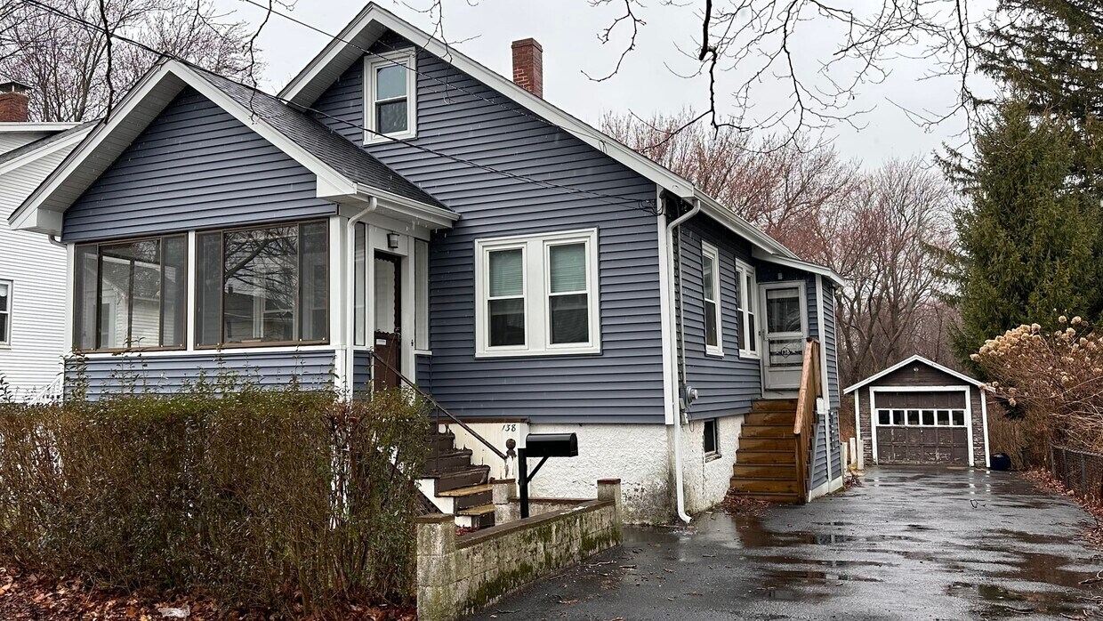
138 Sherman St Unit 138 Sherman Street
Quincy, MA 02170
Today
|
Edit
Favorites
857-403-9528
-
Bedrooms
3
-
Bathrooms
1
-
Square Feet
1,000 sq ft
-
Available
Available Mar 1
Highlights
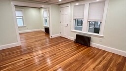
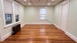
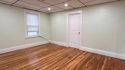
- Hardwood Floors
- Basement
- Smoke Free
138 Sherman St Unit 138 Sherman Street

Favorites
About This Home
16 Month Lease,
$3,150 deposit,
Available Mar 1
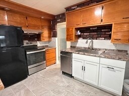
Updated home with refinished hardwood floors, a spacious living room and bedrooms, and a dining room adjacent to the kitchen. Enjoy a private backyard, enclosed three-season front porch, driveway parking, and additional storage with laundry in the basement. Conveniently located about ¾ mile to the Wollaston train station and close to Stop & Shop. No pets and no smoking. Tenants pay for cold and hot water, electric, and gas. Equal housing opportunity.
138 Sherman St is an apartment community located in Norfolk County and the 02170 ZIP Code. This area is served by the Quincy attendance zone.
* Price shown is total price based on community-supplied monthly required fees. Excludes user-selected optional fees and variable or usage-based fees and required charges due at or prior to move-in or at move-out. Price, availability, fees, and any applicable rent special are subject to change without notice.
* Square footage definitions vary. Displayed square footage is approximate.
Apartment Features
Hardwood Floors
Smoke Free
Basement
Dining Room
- Smoke Free
- Kitchen
- Instant Hot Water
- Hardwood Floors
- Dining Room
- Basement
- Laundry Facilities
- Storage Space
- Porch
Fees and Policies
The fees listed below are community-provided and may exclude utilities or add-ons. All payments are made directly to the property and are non-refundable unless otherwise specified.
- Parking
-
Surface Lot--
Details
Utilities Included
-
Trash Removal
Property Information
-
Built in 1930
Contact
- Phone Number
- Contact
Location
Get Directions
The Blue Hills Reservation takes up much of West Quincy. This 6,000-acre state park is one of the Boston area’s largest parcels of undeveloped land, culminating in its highest point, Great Blue Hill. Enjoy panoramic views from this vantage point and visit the historic Blue Hill Meteorological Observatory, founded by meteorologist and MIT grad, Abbott Lawrence Rotch in 1885. It is still active and is open to the public on weekends.
The north end of West Quincy is a wooded, attractive neighborhood with ample sidewalks that residents use for evening strolls or walking their dogs. The neighborhood provides ample mass transit and the Quincy Center subway station is only a mile or so to the east, making commuting throughout the Boston area a breeze.
While West Quincy is largely residential, you’ll find several shops and restaurants along Willard Street, as well as a few local favorites along Adams Street. Be sure to visit Brick & Beam, a rustic tavern, and Dairy Freeze for ice cream.
Learn more about living in West Quincy
Education
| Colleges & Universities | Distance | ||
|---|---|---|---|
| Colleges & Universities | Distance | ||
| Drive: | 11 min | 4.8 mi | |
| Drive: | 15 min | 6.0 mi | |
| Drive: | 15 min | 7.2 mi | |
| Drive: | 14 min | 7.5 mi |
138 Sherman St Unit 138 Sherman Street is within 11 minutes or 4.8 miles from UMass Boston. It is also near Curry College and Northeastern University.
Schools


Public Elementary School
Grades K-5
365 Students
Attendance Zone
Public Elementary School
Grades K-5
642 Students
Nearby
Public Middle School
Grades 6-8
574 Students
Attendance Zone
Public High School
Grades 9-12
1,505 Students
Attendance Zone
Private Elementary & Middle School
Grades PK-8
329 Students
Nearby
Private Middle & High School
Grades 6-12
46 Students
Nearby
School data provided by
 The GreatSchools Rating helps parents compare schools within a state based on a variety of school quality indicators and provides a helpful picture of how effectively each school serves all of its students. Ratings are on a scale of 1 (below average) to 10 (above average) and can include test scores, college readiness, academic progress, advanced courses, equity, discipline and attendance data. We also advise parents to visit schools, consider other information on school performance and programs, and consider family needs as part of the school selection process.
View GreatSchools Rating Methodology
Data provided by GreatSchools.org © 2026. All rights reserved.
View GreatSchools Rating Methodology
Data provided by GreatSchools.org © 2026. All rights reserved.
Transportation options available in Quincy include Wollaston Station, located 0.8 mile from 138 Sherman St Unit 138 Sherman Street. 138 Sherman St Unit 138 Sherman Street is near General Edward Lawrence Logan International, located 10.1 miles or 19 minutes away.
| Transit / Subway | Distance | ||
|---|---|---|---|
| Transit / Subway | Distance | ||
|
|
Walk: | 15 min | 0.8 mi |
|
|
Drive: | 4 min | 1.3 mi |
|
|
Drive: | 6 min | 2.8 mi |
|
|
Drive: | 6 min | 3.0 mi |
|
|
Drive: | 7 min | 3.4 mi |
| Commuter Rail | Distance | ||
|---|---|---|---|
| Commuter Rail | Distance | ||
|
|
Drive: | 5 min | 2.0 mi |
|
|
Drive: | 8 min | 4.2 mi |
| Drive: | 10 min | 4.5 mi | |
| Drive: | 12 min | 4.6 mi | |
| Drive: | 9 min | 4.7 mi |
| Airports | Distance | ||
|---|---|---|---|
| Airports | Distance | ||
|
General Edward Lawrence Logan International
|
Drive: | 19 min | 10.1 mi |
Time and distance from 138 Sherman St Unit 138 Sherman Street.
| Shopping Centers | Distance | ||
|---|---|---|---|
| Shopping Centers | Distance | ||
| Walk: | 11 min | 0.6 mi | |
| Drive: | 3 min | 1.2 mi | |
| Drive: | 4 min | 1.5 mi |
138 Sherman St Unit 138 Sherman Street has 3 shopping centers within 1.5 miles, which is about a 4-minute drive. The miles and minutes will be for the farthest away property.
| Parks and Recreation | Distance | ||
|---|---|---|---|
| Parks and Recreation | Distance | ||
|
Adams National Historical Park
|
Drive: | 5 min | 1.8 mi |
|
Squantum Point Park
|
Drive: | 9 min | 2.9 mi |
|
Dorchester Shores Reservation
|
Drive: | 10 min | 4.7 mi |
|
Mass Audubon's Boston Nature Center and Wildlife Sanctuary
|
Drive: | 11 min | 5.4 mi |
|
Franklin Park Zoo
|
Drive: | 11 min | 6.0 mi |
138 Sherman St Unit 138 Sherman Street has 5 parks within 6.0 miles, including Adams National Historical Park, Squantum Point Park, and Dorchester Shores Reservation.
| Hospitals | Distance | ||
|---|---|---|---|
| Hospitals | Distance | ||
| Drive: | 7 min | 3.3 mi | |
| Drive: | 7 min | 3.5 mi | |
| Drive: | 11 min | 6.2 mi |
138 Sherman St Unit 138 Sherman Street has 3 hospitals within 6.2 miles, the nearest is Beth Israel Deaconess Hospital - Milton which is 3.3 miles away and a 7 minute drive.
Amenities
- Smoke Free
- Kitchen
- Instant Hot Water
- Hardwood Floors
- Dining Room
- Basement
- Laundry Facilities
- Storage Space
- Porch
138 Sherman St Unit 138 Sherman Street Photos
What Are Walk Score®, Transit Score®, and Bike Score® Ratings?
Walk Score® measures the walkability of any address. Transit Score® measures access to public transit. Bike Score® measures the bikeability of any address.
What is a Sound Score Rating?
A Sound Score Rating aggregates noise caused by vehicle traffic, airplane traffic and local sources
138 Sherman St
Quincy, MA 02170