


$2,400
/ Month
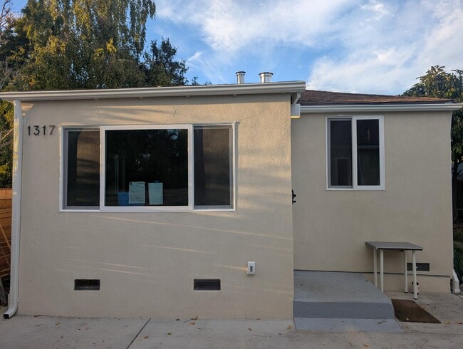
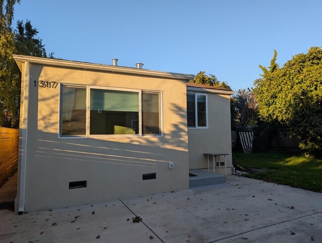
1317 Haskell St
Berkeley, CA 94702
Today
|
Edit
Favorites
910-228-2278
-
Bedrooms
1
-
Bathrooms
1
-
Square Feet
472 sq ft
-
Available
Available Now
1317 Haskell St

Favorites
About This Home
Available Now
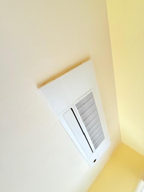
Beautiful sunny ADU set back from the street, behind 2 unit house, completely renovated in 2024-2025, with brand new kitchen and bathroom, energy efficient Heat Pump hot water heater, and heat pump Heat/AC, new on site washer/dryer combo unit (in kitchen). New kitchen appliances include induction stove, dishwasher and Over the range microwave. No gas, all electric. Share back yard with other tenants, and potential to store bicycle in shared locked shed. Garbage service and Berkeley compost pickup included. MOVE IN SPECIAL: Waived application fee and $250 off first month in December or January up to 2/1/26. Beautiful property in great location, close to San Pablo Park, has shared tranquil backyard, and on site property management.
1317 Haskell St is a house located in Alameda County and the 94702 ZIP Code. This area is served by the Berkeley Unified attendance zone.
* Price shown is base rent. Excludes user-selected optional fees and variable or usage-based fees and required charges due at or prior to move-in or at move-out. Price, availability, fees, and any applicable rent special are subject to change without notice.
* Square footage definitions vary. Displayed square footage is approximate.
Contact
- Listed by Thomas Carlin | Thomas Carlin | Thomas Carlin
- Phone Number
- Contact
Location
Get Directions
Southwest Berkeley is bounded by University Avenue to the north, Sacramento Street to the East, Alcatraz Avenue to the south and the San Francisco Bay to the west. Southwest Berkeley comprises a fascinating mix of the educational and the industrial. Less dense than the more inland parts of Berkeley, Southwest Berkeley has a diverse mix of apartment and home rentals that will delight students and families alike. Convenient access to the illustrious university make this a great option for students and staff, but any renter will love the restaurant and retail options that make this walkable locale so convenient.
Learn more about living in Southwest Berkeley
Education
| Colleges & Universities | Distance | ||
|---|---|---|---|
| Colleges & Universities | Distance | ||
| Drive: | 6 min | 2.0 mi | |
| Drive: | 8 min | 3.0 mi | |
| Drive: | 10 min | 3.4 mi | |
| Drive: | 9 min | 3.9 mi |
1317 Haskell St is within 6 minutes or 2.0 miles from Berkeley City College. It is also near Samuel Merritt University and UC Berkeley.
Schools


Public Elementary School
Grades K-5
270 Students
Nearby
Public Elementary School
Grades K-5
370 Students
Attendance Zone
Public Elementary School
Grades K-5
459 Students
Attendance Zone
Public Middle School
Grades 6-8
596 Students
Attendance Zone
Public High School
Grades 9-12
3,204 Students
Attendance Zone
Private Elementary School
Grades K
20 Students
Nearby
Private Elementary & Middle School
Grades PK-8
440 Students
Nearby
School data provided by
 The GreatSchools Rating helps parents compare schools within a state based on a variety of school quality indicators and provides a helpful picture of how effectively each school serves all of its students. Ratings are on a scale of 1 (below average) to 10 (above average) and can include test scores, college readiness, academic progress, advanced courses, equity, discipline and attendance data. We also advise parents to visit schools, consider other information on school performance and programs, and consider family needs as part of the school selection process.
View GreatSchools Rating Methodology
Data provided by GreatSchools.org © 2025. All rights reserved.
View GreatSchools Rating Methodology
Data provided by GreatSchools.org © 2025. All rights reserved.
Transportation options available in Berkeley include Ashby Station, located 0.8 mile from 1317 Haskell St. 1317 Haskell St is near Metro Oakland International, located 13.5 miles or 22 minutes away, and San Francisco International, located 22.8 miles or 36 minutes away.
| Transit / Subway | Distance | ||
|---|---|---|---|
| Transit / Subway | Distance | ||
|
|
Walk: | 16 min | 0.8 mi |
|
|
Drive: | 5 min | 1.9 mi |
|
|
Drive: | 5 min | 1.9 mi |
|
|
Drive: | 6 min | 2.2 mi |
|
|
Drive: | 6 min | 2.2 mi |
| Commuter Rail | Distance | ||
|---|---|---|---|
| Commuter Rail | Distance | ||
|
|
Drive: | 3 min | 1.2 mi |
|
|
Drive: | 5 min | 2.0 mi |
|
|
Drive: | 11 min | 4.7 mi |
| Drive: | 14 min | 8.6 mi | |
| Drive: | 17 min | 10.3 mi |
| Airports | Distance | ||
|---|---|---|---|
| Airports | Distance | ||
|
Metro Oakland International
|
Drive: | 22 min | 13.5 mi |
|
San Francisco International
|
Drive: | 36 min | 22.8 mi |
Time and distance from 1317 Haskell St.
| Shopping Centers | Distance | ||
|---|---|---|---|
| Shopping Centers | Distance | ||
| Drive: | 4 min | 1.5 mi | |
| Drive: | 4 min | 1.5 mi | |
| Drive: | 5 min | 1.8 mi |
1317 Haskell St has 3 shopping centers within 1.8 miles, which is about a 5-minute drive. The miles and minutes will be for the farthest away property.
| Parks and Recreation | Distance | ||
|---|---|---|---|
| Parks and Recreation | Distance | ||
|
San Francisco Bay Trail (at Emeryville)
|
Drive: | 3 min | 1.3 mi |
|
Strawberry Creek Park
|
Drive: | 4 min | 1.6 mi |
|
Willard Park
|
Drive: | 6 min | 1.8 mi |
|
Habitot Children's Museum
|
Drive: | 6 min | 2.0 mi |
|
People's Park
|
Drive: | 7 min | 2.2 mi |
1317 Haskell St has 5 parks within 2.2 miles, including Strawberry Creek Park, San Francisco Bay Trail (at Emeryville), and Willard Park.
| Hospitals | Distance | ||
|---|---|---|---|
| Hospitals | Distance | ||
| Drive: | 5 min | 1.5 mi | |
| Drive: | 4 min | 1.6 mi | |
| Drive: | 7 min | 2.9 mi |
1317 Haskell St has 3 hospitals within 2.9 miles, the nearest is Alta Bates Summit Medical Center - Alta Bates Campus which is 1.5 miles away and a 5 minute drive.
| Military Bases | Distance | ||
|---|---|---|---|
| Military Bases | Distance | ||
| Drive: | 14 min | 5.8 mi | |
| Drive: | 17 min | 7.4 mi |
1317 Haskell St is 5.8 miles from Oakland Army Base, and is convenient to other military bases, including Alameda/US Naval Air Station Alameda.
You May Also Like
Similar Rentals Nearby


What Are Walk Score®, Transit Score®, and Bike Score® Ratings?
Walk Score® measures the walkability of any address. Transit Score® measures access to public transit. Bike Score® measures the bikeability of any address.
What is a Sound Score Rating?
A Sound Score Rating aggregates noise caused by vehicle traffic, airplane traffic and local sources
1317 Haskell St
Berkeley, CA 94702