
$2,200
/ Month
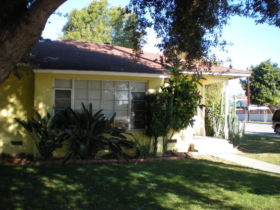
1305 W 6th St
Pomona, CA 91766
2 Weeks Ago
|
Edit
Favorites
1305 W 6th St

Favorites
Check Back Soon for Upcoming Availability
| Beds | Baths | Average SF |
|---|---|---|
| 3 Bedrooms 3 Bedrooms 3 Br | 1 Bath 1 Bath 1 Ba | 1,083 SF |
Fees and Policies
The fees below are based on community-supplied data and may exclude additional fees and utilities.
- Parking
-
Garage--
About This Property
3 bedroom 1 bath home located on the NW corner of Buena Vista and 6th street. Fenced yard, 2 car detached garage. 1,083 square foot 3 bedroom 1 bath home with 2 car detached garage. Located 1 block south of Mission on the corner of Buena Vista & 6th.
1305 W 6th St is a house located in Los Angeles County and the 91766 ZIP Code. This area is served by the Pomona Unified attendance zone.
House Features
- Washer/Dryer Hookup
- Yard
Location
Get Directions
Located in the Pomona Valley, Pomona offers renters a welcoming community with a rich history and convenient amenities. California State Polytechnic University and Western University of Health Sciences anchor the educational landscape, while downtown features the restored Fox Theater and a growing Arts District. Outdoor recreation opportunities abound at Ganesha Park, and the Fairplex hosts the Los Angeles County Fair along with year-round events. Current rental rates average $1,742 for one-bedroom units, with options available in established neighborhoods like Phillips Ranch and the Lincoln Park Historic District.
Situated 30 miles east of Los Angeles, Pomona combines suburban living with easy access to metropolitan areas. The rental market includes a range of housing choices near both university campuses and throughout residential neighborhoods. Tree-lined streets and preserved architecture reflect the city's heritage as a citrus-growing center.
Learn more about living in Pomona
Amenities
- Washer/Dryer Hookup
- Yard
Education
| Colleges & Universities | Distance | ||
|---|---|---|---|
| Colleges & Universities | Distance | ||
| Drive: | 3 min | 1.4 mi | |
| Drive: | 7 min | 2.9 mi | |
| Drive: | 9 min | 3.9 mi | |
| Drive: | 8 min | 4.0 mi |
1305 W 6th St is within 3 minutes or 1.4 miles from Western Health Scis., Pomono. It is also near DeVry University-California and University of La Verne.
Schools


Public Elementary School
Grades K-6
441 Students
Attendance Zone
Public Middle & High School
Grades 7-12
719 Students
Attendance Zone
Public High School
Grades 9-12
936 Students
Attendance Zone
Private Elementary, Middle & High School
Grades PK-12
Nearby
Private Elementary School
Grades K-5
79 Students
Nearby
Private High School
Grades 9-12
312 Students
Nearby
School data provided by
 The GreatSchools Rating helps parents compare schools within a state based on a variety of school quality indicators and provides a helpful picture of how effectively each school serves all of its students. Ratings are on a scale of 1 (below average) to 10 (above average) and can include test scores, college readiness, academic progress, advanced courses, equity, discipline and attendance data. We also advise parents to visit schools, consider other information on school performance and programs, and consider family needs as part of the school selection process.
View GreatSchools Rating Methodology
Data provided by GreatSchools.org © 2025. All rights reserved.
View GreatSchools Rating Methodology
Data provided by GreatSchools.org © 2025. All rights reserved.
Transportation options available in Pomona include Apu / Citrus College Station, located 11.8 miles from 1305 W 6th St. 1305 W 6th St is near Ontario International, located 10.2 miles or 17 minutes away, and John Wayne/Orange County, located 32.2 miles or 40 minutes away.
| Transit / Subway | Distance | ||
|---|---|---|---|
| Transit / Subway | Distance | ||
| Drive: | 17 min | 11.8 mi | |
| Drive: | 16 min | 12.4 mi |
| Commuter Rail | Distance | ||
|---|---|---|---|
| Commuter Rail | Distance | ||
|
|
Drive: | 2 min | 1.2 mi |
|
|
Drive: | 8 min | 4.1 mi |
|
|
Drive: | 9 min | 5.5 mi |
|
|
Drive: | 11 min | 6.6 mi |
|
|
Drive: | 12 min | 7.7 mi |
| Airports | Distance | ||
|---|---|---|---|
| Airports | Distance | ||
|
Ontario International
|
Drive: | 17 min | 10.2 mi |
|
John Wayne/Orange County
|
Drive: | 40 min | 32.2 mi |
Time and distance from 1305 W 6th St.
| Shopping Centers | Distance | ||
|---|---|---|---|
| Shopping Centers | Distance | ||
| Walk: | 13 min | 0.7 mi | |
| Walk: | 20 min | 1.0 mi | |
| Drive: | 2 min | 1.3 mi |
1305 W 6th St has 3 shopping centers within 1.3 miles, which is about a 2-minute drive. The miles and minutes will be for the farthest away property.
| Parks and Recreation | Distance | ||
|---|---|---|---|
| Parks and Recreation | Distance | ||
|
Frank G. Bonelli Regional Park
|
Drive: | 9 min | 5.2 mi |
|
Millikan Planetarium
|
Drive: | 11 min | 5.9 mi |
|
Pitzer College Arboretum
|
Drive: | 11 min | 6.6 mi |
|
Rancho Santa Ana Botanic Garden
|
Drive: | 11 min | 6.7 mi |
|
Alf Museum of Paleontology
|
Drive: | 13 min | 6.8 mi |
1305 W 6th St has 5 parks within 6.8 miles, including Frank G. Bonelli Regional Park, Millikan Planetarium, and Alf Museum of Paleontology.
| Hospitals | Distance | ||
|---|---|---|---|
| Hospitals | Distance | ||
| Drive: | 4 min | 2.6 mi | |
| Drive: | 7 min | 4.1 mi | |
| Drive: | 8 min | 5.3 mi |
1305 W 6th St has 3 hospitals within 5.3 miles, the nearest is Pomona Valley Hospital Medical Center which is 2.6 miles away and a 4 minute drive.
| Military Bases | Distance | ||
|---|---|---|---|
| Military Bases | Distance | ||
| Drive: | 43 min | 32.1 mi |
1305 W 6th St is 32.1 miles and a 43 minute drive from Los Alamitos Army Airfield.
You May Also Like
Similar Rentals Nearby


What Are Walk Score®, Transit Score®, and Bike Score® Ratings?
Walk Score® measures the walkability of any address. Transit Score® measures access to public transit. Bike Score® measures the bikeability of any address.
What is a Sound Score Rating?
A Sound Score Rating aggregates noise caused by vehicle traffic, airplane traffic and local sources
1305 W 6th St
Pomona, CA 91766