$1,900
/ Month
1304 Eagles Way
Leander, TX 78641
Today
|
Edit
Favorites
512-289-5312
-
Bedrooms
3
-
Bathrooms
2
-
Square Feet
1,344 sq ft
-
Available
Available Now
Highlights
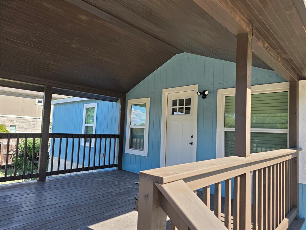
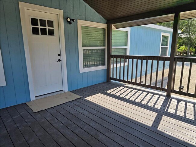
- Deck
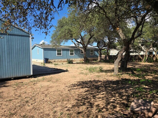
- Wooded Lot
- Private Yard
- Covered Patio or Porch
- Shed
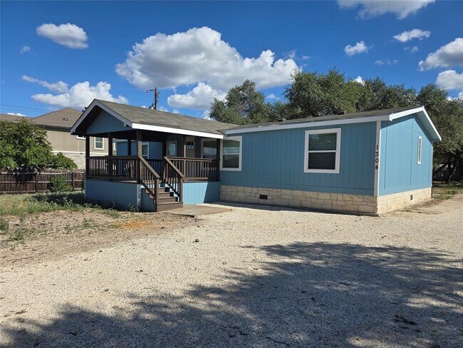
- 1-Story Property
1304 Eagles Way

Favorites
About This Home
Available Now
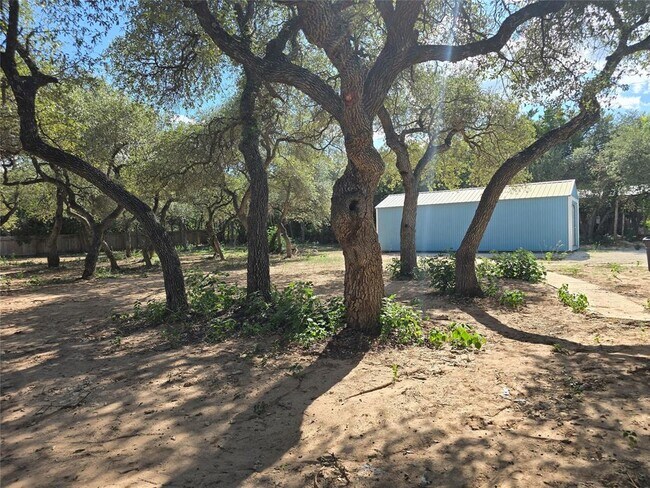
Unique property sited on a large lot .75 of an acre and surrounded by beautiful oak trees, little restrictions, if you have a work trailer or a work truck you can park here. HM has been totally renovated and makes it feel like a house. Interior features all wood looking laminate floors, No Carpet. Center island, new cabinets, quartz counters all new appliances, new central AC, nice covered porch, and comes with huge storage. No HOA.
1304 Eagles Way is a house located in Williamson County and the 78641 ZIP Code. This area is served by the Leander Independent attendance zone.
* Price shown is base rent. Excludes user-selected optional fees and variable or usage-based fees and required charges due at or prior to move-in or at move-out. Price, availability, fees, and any applicable rent special are subject to change without notice.
* Square footage definitions vary. Displayed square footage is approximate.
Home Details
Home Type
Mobile Home
Year Built
Built in 1994
Bedrooms and Bathrooms
3 Main Level Bedrooms
2 Full Bathrooms
Home Design
Composition Roof
Interior Spaces
1-Story Property
Ceiling Fan
Laminate Flooring
1,344 Sq Ft Home
Listing and Financial Details
Security Deposit $2,300
$65 Application Fee
Assessor Parcel Number 17W323801B00170004
Tax Block B
Tenant pays for all utilities
Lot Details
0.75 Acre Lot
Wooded Lot
Private Yard
North Facing Home
Partially Fenced Property
Level Lot
Lot Dimensions are 120 x 273
Outdoor Features
Deck
Covered Patio or Porch
Shed
Parking
Driveway
4 Parking Spaces
Schools
Camacho Elementary School
Leander Middle School
Leander High School
Utilities
Central Heating and Cooling System
Septic Tank
Community Details
Overview
No Home Owners Association
Falcon Oaks Sec 1 Subdivision
Pet Policy
Small pets allowed
Pet Deposit $350
Contact
- Listed by Carlos Flores | One of a Kind Realty
- Phone Number
- Contact
-
Source
 Austin Board of REALTORS®
The information included in this listing is provided exclusively for consumers’ personal, non-commercial use and may not be used for any purpose other than to identify prospective properties consumers may be interested in purchasing. The information on each listing is furnished by the owner and deemed reliable to the best of his/her knowledge, but should be verified by the purchaser. ABoR, ACTRIS and Estately assume no responsibility for typographical errors, misprints or misinformation. This property listing is offered without respect to any protected classes in accordance with the law. Copyright © 2025.
Location
Get Directions
Located 22 miles northwest of Austin, Leander combines Hill Country scenery with suburban living. The city features established neighborhoods like Mason Creek, Travisso, and Crystal Falls, each offering their own mix of housing options from single-family homes to townhouses.
Parks and outdoor spaces define Leander's landscape, including Benbrook Ranch Park's skating facilities and Robin Bledsoe Park's pool and sports courts. The city's natural limestone formations and rolling hills provide scenic backdrops for hiking and biking trails throughout the area.
Archaeological significance adds to Leander's character, as the site of the "Leanderthal Lady" discovery represents one of North America's oldest burial sites. The MetroRail Red Line's Leander Station connects residents to downtown Austin, while major thoroughfares provide access to the region's employment centers.
Learn more about living in Leander
Education
| Colleges & Universities | Distance | ||
|---|---|---|---|
| Colleges & Universities | Distance | ||
| Drive: | 13 min | 6.6 mi | |
| Drive: | 24 min | 12.5 mi | |
| Drive: | 26 min | 15.7 mi | |
| Drive: | 25 min | 17.7 mi |
1304 Eagles Way is within 13 minutes or 6.6 miles from Austin C.C., Cypress Creek. It is also near Concordia University Texas and Austin C.C., Round Rock Campus.
Schools


Public Elementary School
Grades PK-5
680 Students
Attendance Zone
Public Middle School
Grades 6-8
802 Students
Attendance Zone
Public High School
Grades 9-12
2,063 Students
Attendance Zone
Private Elementary, Middle & High School
Grades PK-12
Nearby
School data provided by
 The GreatSchools Rating helps parents compare schools within a state based on a variety of school quality indicators and provides a helpful picture of how effectively each school serves all of its students. Ratings are on a scale of 1 (below average) to 10 (above average) and can include test scores, college readiness, academic progress, advanced courses, equity, discipline and attendance data. We also advise parents to visit schools, consider other information on school performance and programs, and consider family needs as part of the school selection process.
View GreatSchools Rating Methodology
Data provided by GreatSchools.org © 2025. All rights reserved.
View GreatSchools Rating Methodology
Data provided by GreatSchools.org © 2025. All rights reserved.
Transportation options available in Leander include Leander Station, located 2.8 miles from 1304 Eagles Way. 1304 Eagles Way is near Austin-Bergstrom International, located 37.6 miles or 52 minutes away, and Robert Gray AAF, located 42.0 miles or 66 minutes away.
| Transit / Subway | Distance | ||
|---|---|---|---|
| Transit / Subway | Distance | ||
| Drive: | 6 min | 2.8 mi | |
| Drive: | 17 min | 8.8 mi |
| Commuter Rail | Distance | ||
|---|---|---|---|
| Commuter Rail | Distance | ||
|
|
Drive: | 36 min | 26.5 mi |
|
|
Drive: | 48 min | 37.9 mi |
| Airports | Distance | ||
|---|---|---|---|
| Airports | Distance | ||
|
Austin-Bergstrom International
|
Drive: | 52 min | 37.6 mi |
|
Robert Gray AAF
|
Drive: | 66 min | 42.0 mi |
Time and distance from 1304 Eagles Way.
| Shopping Centers | Distance | ||
|---|---|---|---|
| Shopping Centers | Distance | ||
| Drive: | 3 min | 1.3 mi | |
| Drive: | 3 min | 1.4 mi | |
| Drive: | 4 min | 1.4 mi |
1304 Eagles Way has 3 shopping centers within 1.4 miles, which is about a 4-minute drive. The miles and minutes will be for the farthest away property.
| Parks and Recreation | Distance | ||
|---|---|---|---|
| Parks and Recreation | Distance | ||
|
Austin Steam Train
|
Drive: | 9 min | 4.7 mi |
|
Garey Park
|
Drive: | 19 min | 7.5 mi |
1304 Eagles Way has 2 parks within 7.5 miles, including Austin Steam Train, and Garey Park.
| Hospitals | Distance | ||
|---|---|---|---|
| Hospitals | Distance | ||
| Drive: | 11 min | 6.0 mi | |
| Drive: | 23 min | 16.3 mi |
1304 Eagles Way is 6.0 miles from Cedar Park Regional Medical Center, and is convenient to other hospitals, including Round Rock Medical Center.
| Military Bases | Distance | ||
|---|---|---|---|
| Military Bases | Distance | ||
| Drive: | 71 min | 53.2 mi | |
| Drive: | 136 min | 107.7 mi |
1304 Eagles Way is 53.2 miles from Fort Hood, and is convenient to other military bases, including Camp Bullis Military Training Reservation.
You May Also Like
Similar Rentals Nearby
-
-
-
-
1 / 12

-
-
-
-
1 / 10

-
-


What Are Walk Score®, Transit Score®, and Bike Score® Ratings?
Walk Score® measures the walkability of any address. Transit Score® measures access to public transit. Bike Score® measures the bikeability of any address.
What is a Sound Score Rating?
A Sound Score Rating aggregates noise caused by vehicle traffic, airplane traffic and local sources

1304 Eagles Way
Leander, TX 78641