
$2,150
/ Month
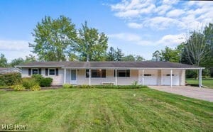
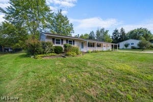
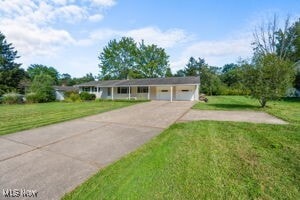
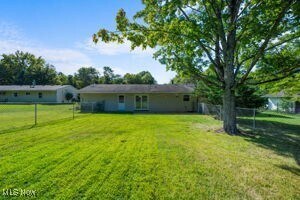
13015 Caves Rd
Chesterland, OH 44026
Today
|
Edit
Favorites
216-703-5740
-
Bedrooms
3
-
Bathrooms
1.5
-
Square Feet
--
-
Available
Available Now
Highlights
- 2 Car Detached Garage
- Fireplace
- No Cooling
- Forced Air Heating System
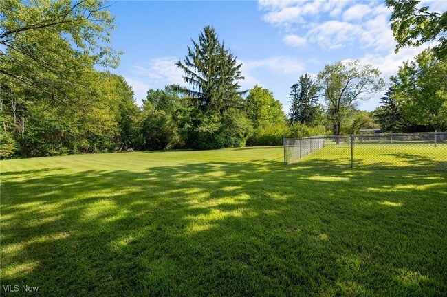
- Partially Fenced Property
- 1-Story Property
13015 Caves Rd

Favorites
About This Home
Available Now
Just Updated open floor plan 3 Bed 1 1/2 Bath Attached 2 Car Garage. There is an extra room that can be used for a dining room or Family Room of your choice. Large Fenced area in the Backyard. Large Lot with a septic and Sewer. No Utilities except Electric. Must See
13015 Caves Rd is a house located in Geauga County and the 44026 ZIP Code. This area is served by the West Geauga Local attendance zone.
* Price shown is base rent. Excludes user-selected optional fees and variable or usage-based fees and required charges due at or prior to move-in or at move-out. Price, availability, fees, and any applicable rent special are subject to change without notice.
* Square footage definitions vary. Displayed square footage is approximate.
Home Details
Home Type
Single Family Detached Home
Year Built
Built in 1956 | Remodeled
Bedrooms and Bathrooms
1.5 Bathrooms
3 Bedrooms
Home Security
Carbon Monoxide Detectors
Fire and Smoke Detector
Interior Spaces
Fireplace
1,200 Sq Ft Home
1-Story Property
Kitchen
Range
Disposal
Laminate Countertops
Laundry
Dryer
Laundry in unit
Washer
Listing and Financial Details
12 Month Lease Term
Assessor Parcel Number 11-167100
Tenant pays for all utilities
Lot Details
1 Acre Lot
Partially Fenced Property
Chain Link Fence
Parking
2 Car Detached Garage
Additional Parking
Driveway
Utilities
No Cooling
Forced Air Heating System
Heating System Uses Gas
Septic Tank
Community Details
Overview
Chester Estates Sub 1 Tr 3 Subdivision
Contact
- Listed by Brett A Young | KEY REALTY
- Phone Number
- Contact
-
Source
 MLS Now
Copyright 2025 © MLS Now. All rights reserved.
Location
Get Directions
Education
| Colleges & Universities | Distance | ||
|---|---|---|---|
| Colleges & Universities | Distance | ||
| Drive: | 15 min | 7.5 mi | |
| Drive: | 21 min | 10.7 mi | |
| Drive: | 20 min | 10.7 mi | |
| Drive: | 20 min | 12.5 mi |
13015 Caves Rd is within 15 minutes or 7.5 miles from Ursuline College. It is also near Lakeland C.C., Main - Kirtland and Notre Dame College.
Schools


Public Elementary School
Grades PK-3
485 Students
Nearby
Public Elementary School
Grades 3-6
461 Students
Attendance Zone
Public Elementary School
Grades K-2
432 Students
Attendance Zone
Public Middle School
Grades 6-9
491 Students
Attendance Zone
Public High School
Grades 9-12
693 Students
Attendance Zone
Private Elementary, Middle & High School
Grades PK-12
1,152 Students
Nearby
Private Elementary & Middle School
Grades PK-8
196 Students
Nearby
School data provided by
 The GreatSchools Rating helps parents compare schools within a state based on a variety of school quality indicators and provides a helpful picture of how effectively each school serves all of its students. Ratings are on a scale of 1 (below average) to 10 (above average) and can include test scores, college readiness, academic progress, advanced courses, equity, discipline and attendance data. We also advise parents to visit schools, consider other information on school performance and programs, and consider family needs as part of the school selection process.
View GreatSchools Rating Methodology
Data provided by GreatSchools.org © 2025. All rights reserved.
View GreatSchools Rating Methodology
Data provided by GreatSchools.org © 2025. All rights reserved.
Transportation options available in Chesterland include Green, located 11.4 miles from 13015 Caves Rd. 13015 Caves Rd is near Cleveland-Hopkins International, located 32.6 miles or 48 minutes away.
| Transit / Subway | Distance | ||
|---|---|---|---|
| Transit / Subway | Distance | ||
|
|
Drive: | 21 min | 11.4 mi |
|
|
Drive: | 21 min | 11.5 mi |
|
|
Drive: | 22 min | 12.5 mi |
|
|
Drive: | 23 min | 12.9 mi |
|
|
Drive: | 21 min | 13.1 mi |
| Commuter Rail | Distance | ||
|---|---|---|---|
| Commuter Rail | Distance | ||
| Drive: | 34 min | 22.1 mi | |
| Drive: | 37 min | 23.8 mi | |
| Drive: | 42 min | 26.1 mi | |
|
|
Drive: | 38 min | 26.1 mi |
|
Boston Mill
|
Drive: | 43 min | 29.0 mi |
| Airports | Distance | ||
|---|---|---|---|
| Airports | Distance | ||
|
Cleveland-Hopkins International
|
Drive: | 48 min | 32.6 mi |
Time and distance from 13015 Caves Rd.
| Shopping Centers | Distance | ||
|---|---|---|---|
| Shopping Centers | Distance | ||
| Walk: | 19 min | 1.0 mi | |
| Walk: | 19 min | 1.0 mi | |
| Drive: | 4 min | 1.8 mi |
13015 Caves Rd has 3 shopping centers within 1.8 miles, which is about a 4-minute walk. The miles and minutes will be for the farthest away property.
| Parks and Recreation | Distance | ||
|---|---|---|---|
| Parks and Recreation | Distance | ||
|
Bessie Benner Metzenbaum Park
|
Walk: | 13 min | 0.7 mi |
|
Sunnybrook Preserve
|
Drive: | 10 min | 5.3 mi |
|
The West Woods
|
Drive: | 11 min | 6.3 mi |
|
The Rookery
|
Drive: | 18 min | 6.9 mi |
|
Farmpark
|
Drive: | 17 min | 7.9 mi |
13015 Caves Rd has 5 parks within 7.9 miles, including Bessie Benner Metzenbaum Park, Sunnybrook Preserve, and The West Woods.
| Hospitals | Distance | ||
|---|---|---|---|
| Hospitals | Distance | ||
| Drive: | 8 min | 4.8 mi | |
| Drive: | 19 min | 11.1 mi | |
| Drive: | 20 min | 12.8 mi |
13015 Caves Rd has 3 hospitals within 12.8 miles, the nearest is Hillcrest Hospital which is 4.8 miles away and a 8 minute drive.
You May Also Like
Similar Rentals Nearby


What Are Walk Score®, Transit Score®, and Bike Score® Ratings?
Walk Score® measures the walkability of any address. Transit Score® measures access to public transit. Bike Score® measures the bikeability of any address.
What is a Sound Score Rating?
A Sound Score Rating aggregates noise caused by vehicle traffic, airplane traffic and local sources

13015 Caves Rd
Chesterland, OH 44026