

$2,500
/ Month
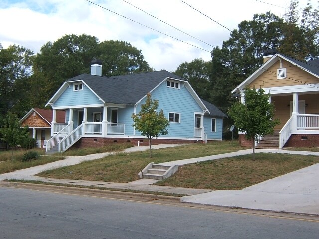
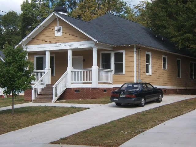
1287 Sells Ave SW
Atlanta, GA 30310
Today
Favorites
470-670-6728
-
Bedrooms
4
-
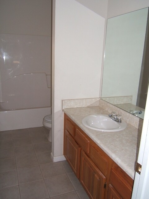
Bathrooms
2
-
Square Feet
1,683 sq ft
-
Available
Available Now
1287 Sells Ave SW

Favorites
About This Home
$2,500 deposit,
Available Now
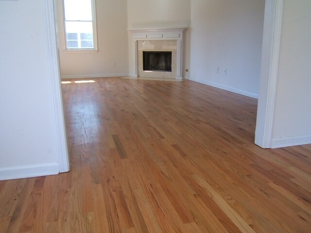
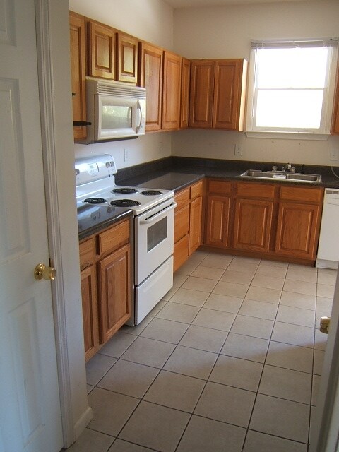
This newer (2005) house features 4 bedrooms and 2 bathrooms, hardwood floors, and a large, level back yard. There is off-street parking and quick access to I-20. The Beltline is within walking distance, and nearby Enota Park is currently getting an upgrade. Nearby are Kroger, CVS, Monday Night Brewing/West End Brewing, and much more. Monthly fees are trash ($50) and lawn care ($55). This is newer construction on a large, level lot. 4 generous bedrooms, 2 full baths (one en-suite in master bedroom.) Hardwood floors in living and dining rooms, tiled kitchen. Off-street parking, quick access to I-20, 2 blocks from the Beltline. Nearby are Kroger, CVS. Additional fees for trash collection ($50/month) and lawn care ($80/month). House is all-electric; tenant pays water and electric. This is a great house, and we are looking for great tenants. Credit score must be over 600. Excellent employment history. 2-year lease strongly preferred. Pets are allows with deposit.
1287 Sells Ave SW is a house located in Fulton County and the 30310 ZIP Code. This area is served by the Atlanta Public Schools attendance zone.
* Price shown is base rent and may not include non-optional fees and utilities. Price, availability, fees, and any applicable rent special are subject to change without notice.
* Square footage definitions vary. Displayed square footage is approximate.
House Features
Air Conditioning
Dishwasher
Hardwood Floors
Refrigerator
- Air Conditioning
- Cable Ready
- Fireplace
- Dishwasher
- Range
- Refrigerator
- Hardwood Floors
Contact
- Listed by Property Manager
- Phone Number
- Contact
Location
Get Directions
Amenities
- Air Conditioning
- Cable Ready
- Fireplace
- Dishwasher
- Range
- Refrigerator
- Hardwood Floors
Located just southwest of Downtown Atlanta, the West End is a historic neighborhood home to charming residences and a vibrant community. The West End’s cultural amenities extend beyond its many exciting, diverse restaurants. The neighborhood is also home to the Hammond House Museum and the Wren’s Nest, where residents can delve into the area’s storied, artistic past.
The West End community comes together for an array of community meetings and festivals. Options for outdoor recreation abound at West End Park, Howell Park, and the Atlanta Beltline’s Westside Trail, which cuts directly through the neighborhood. There are plenty excellent shopping opportunities at the Mall at West End as well.
The West End’s convenient, in-town location is a major draw for many neighborhood residents. Morehouse College, Spelman College, Clark Atlanta University, and Morris Brown College are all close by.
Learn more about living in West End
Education
| Colleges & Universities | Distance | ||
|---|---|---|---|
| Colleges & Universities | Distance | ||
| Drive: | 3 min | 1.4 mi | |
| Drive: | 3 min | 1.5 mi | |
| Drive: | 4 min | 1.6 mi | |
| Drive: | 3 min | 1.8 mi |
1287 Sells Ave SW is within 3 minutes or 1.4 miles from Morehouse College. It is also near Morehouse School of Medicine and Clark Atlanta University.
Schools


Public Elementary School
Grades PK-5
461 Students
Attendance Zone
Public Middle School
Grades 6-8
399 Students
Attendance Zone
Public High School
Grades 9-12
831 Students
Attendance Zone
Private Elementary, Middle & High School
Grades 3-10
7 Students
Nearby
Private Elementary School
Grades PK-5
48 Students
Nearby
Private Elementary, Middle & High School
Grades K-12
Nearby
School data provided by
 The GreatSchools Rating helps parents compare schools within a state based on a variety of school quality indicators and provides a helpful picture of how effectively each school serves all of its students. Ratings are on a scale of 1 (below average) to 10 (above average) and can include test scores, college readiness, academic progress, advanced courses, equity, discipline and attendance data. We also advise parents to visit schools, consider other information on school performance and programs, and consider family needs as part of the school selection process.
View GreatSchools Rating Methodology
Data provided by GreatSchools.org © 2025. All rights reserved.
View GreatSchools Rating Methodology
Data provided by GreatSchools.org © 2025. All rights reserved.
Transportation options available in Atlanta include West End, located 1.4 miles from 1287 Sells Ave SW. 1287 Sells Ave SW is near Hartsfield - Jackson Atlanta International, located 10.8 miles or 17 minutes away.
| Transit / Subway | Distance | ||
|---|---|---|---|
| Transit / Subway | Distance | ||
|
|
Drive: | 3 min | 1.4 mi |
|
|
Drive: | 3 min | 1.7 mi |
|
|
Drive: | 3 min | 1.9 mi |
|
|
Drive: | 5 min | 2.5 mi |
|
|
Drive: | 6 min | 3.7 mi |
| Commuter Rail | Distance | ||
|---|---|---|---|
| Commuter Rail | Distance | ||
|
|
Drive: | 12 min | 7.2 mi |
| Airports | Distance | ||
|---|---|---|---|
| Airports | Distance | ||
|
Hartsfield - Jackson Atlanta International
|
Drive: | 17 min | 10.8 mi |
Time and distance from 1287 Sells Ave SW.
| Shopping Centers | Distance | ||
|---|---|---|---|
| Shopping Centers | Distance | ||
| Walk: | 13 min | 0.7 mi | |
| Walk: | 15 min | 0.8 mi | |
| Walk: | 19 min | 1.0 mi |
1287 Sells Ave SW has 3 shopping centers within 1.0 mile, which is about a 19-minute walk. The miles and minutes will be for the farthest away property.
| Parks and Recreation | Distance | ||
|---|---|---|---|
| Parks and Recreation | Distance | ||
|
West Atlanta Watershed Alliance (WAWA)
|
Drive: | 4 min | 1.6 mi |
|
Park Pride
|
Drive: | 4 min | 2.3 mi |
|
Atlanta BeltLine Southwest Connector Spur Trail
|
Drive: | 7 min | 2.8 mi |
|
The Georgia Capitol Museum
|
Drive: | 4 min | 2.8 mi |
|
Georgia Aquarium
|
Drive: | 6 min | 3.4 mi |
1287 Sells Ave SW has 5 parks within 3.4 miles, including West Atlanta Watershed Alliance (WAWA), Park Pride, and Atlanta BeltLine Southwest Connector Spur Trail.
| Hospitals | Distance | ||
|---|---|---|---|
| Hospitals | Distance | ||
| Drive: | 6 min | 3.2 mi | |
| Drive: | 7 min | 4.0 mi | |
| Drive: | 7 min | 4.3 mi |
1287 Sells Ave SW has 3 hospitals within 4.3 miles, the nearest is Grady Memorial Hospital which is 3.2 miles away and a 6 minute drive.
| Military Bases | Distance | ||
|---|---|---|---|
| Military Bases | Distance | ||
| Drive: | 8 min | 3.7 mi | |
| Drive: | 25 min | 14.1 mi |
1287 Sells Ave SW is 3.7 miles from Fort McPherson, and is convenient to other military bases, including Fort Gillem.
You May Also Like
Similar Rentals Nearby
-
-

-
-
1 / 28

-
-
1 / 23

-
-

-

-


What Are Walk Score®, Transit Score®, and Bike Score® Ratings?
Walk Score® measures the walkability of any address. Transit Score® measures access to public transit. Bike Score® measures the bikeability of any address.
What is a Sound Score Rating?
A Sound Score Rating aggregates noise caused by vehicle traffic, airplane traffic and local sources
1287 Sells Ave SW
Atlanta, GA 30310