

$3,300 / Month
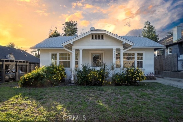
1285 N Raymond Ave
Pasadena, CA 91103
2 Weeks Ago
Favorites
1285 N Raymond Ave

Favorites
Check Back Soon for Upcoming Availability
| Beds | Baths | Average SF |
|---|---|---|
| 2 Bedrooms 2 Bedrooms 2 Br | 1 Bath 1 Bath 1 Ba | 1,054 SF |
Fees and Policies
The fees below are based on community-supplied data and may exclude additional fees and utilities.
- Parking
-
Garage--
Details
Lease Options
-
12 Months
About This Property
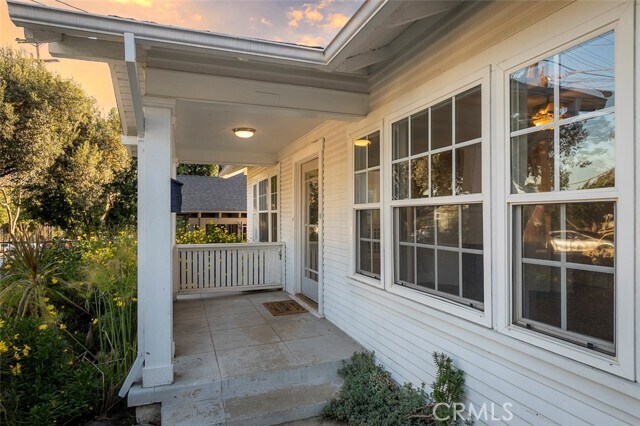
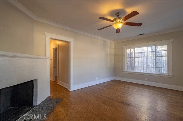
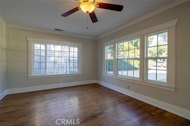
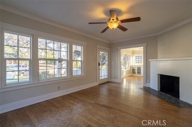
Welcome home to this adorable, sunny Craftsman bungalow. Clean and bright 1920’s cottage has historic charm with recent updates, central heat and air, and hardwood floors. Hex tile flooring in the updated kitchen and bath, original built-in buffet in the dedicated dining area, and lots of natural light throughout. Step out of the kitchen into the spacious backyard for your morning coffee, picnics or barbecues. Just walk out and pick your own oranges from the fruit tree. There’s even plenty of room for a garden. Lots of driveway parking in addition to the detached one-car garage. Convenient to Rose Bowl and Historic Old Towne with groceries and restaurants nearby.
1285 N Raymond Ave is a house located in Los Angeles County and the 91103 ZIP Code. This area is served by the Pasadena Unified attendance zone.
House Features
Washer/Dryer
Air Conditioning
Hardwood Floors
Refrigerator
- Washer/Dryer
- Air Conditioning
- Heating
- Fireplace
- Disposal
- Oven
- Range
- Refrigerator
- Breakfast Nook
- Hardwood Floors
- Tile Floors
- Dining Room
- Views
- Patio
Location
Get Directions
Near the San Gabriel Mountains, where I-210 meets State Route 134 and becomes the Foothill Freeway, rests Pasadena’s Garfield Heights neighborhood. Primarily a residential area, Garfield Heights contains a number of markets, churches, and temples. Garfield Heights residents enjoy access to neighboring parks such as La Pintoresca Park and City of Pasadena Robinson Park.
There are a host of amenities located within close proximity to Garfield Heights. Among the many amenities are the Rose Bowl Stadium, Kidspace Children’s Museum, Norton Simon Museum, Brookside Golf and Country Club, Pasadena Convention Center, Paseo Colorado, and the California Institute of Technology.
Served by several Metro Local lines and Pasadena Transit routes, getting around Garfield Height is a breeze.
Learn more about living in Garfield HeightsBelow are rent ranges for similar nearby apartments
Amenities
- Washer/Dryer
- Air Conditioning
- Heating
- Fireplace
- Disposal
- Oven
- Range
- Refrigerator
- Breakfast Nook
- Hardwood Floors
- Tile Floors
- Dining Room
- Views
- Patio
Education
| Colleges & Universities | Distance | ||
|---|---|---|---|
| Colleges & Universities | Distance | ||
| Drive: | 4 min | 1.9 mi | |
| Drive: | 9 min | 3.1 mi | |
| Drive: | 7 min | 3.4 mi | |
| Drive: | 8 min | 3.6 mi |
1285 N Raymond Ave is within 4 minutes or 1.9 miles from Fuller Theological Seminary. It is also near Art Center College of Design and Pasadena City College.
Schools


Public Elementary School
Grades K-6
454 Students
Nearby
Public Elementary School
Grades K-5
406 Students
Attendance Zone
Public Middle School
Grades 6-8
513 Students
Attendance Zone
Public High School
Grades 9-12
1,012 Students
Attendance Zone
Private Elementary, Middle & High School
Grades 1-12
270 Students
Nearby
Private Elementary & Middle School
Grades PK-8
444 Students
Nearby
Private Elementary School
Grades PK-6
39 Students
Nearby
School data provided by
 The GreatSchools Rating helps parents compare schools within a state based on a variety of school quality indicators and provides a helpful picture of how effectively each school serves all of its students. Ratings are on a scale of 1 (below average) to 10 (above average) and can include test scores, college readiness, academic progress, advanced courses, equity, discipline and attendance data. We also advise parents to visit schools, consider other information on school performance and programs, and consider family needs as part of the school selection process.
View GreatSchools Rating Methodology
Data provided by GreatSchools.org © 2025. All rights reserved.
View GreatSchools Rating Methodology
Data provided by GreatSchools.org © 2025. All rights reserved.
Transportation options available in Pasadena include Memorial Park Station, located 1.7 miles from 1285 N Raymond Ave. 1285 N Raymond Ave is near Bob Hope, located 17.4 miles or 24 minutes away, and Los Angeles International, located 25.9 miles or 42 minutes away.
| Transit / Subway | Distance | ||
|---|---|---|---|
| Transit / Subway | Distance | ||
|
|
Drive: | 4 min | 1.7 mi |
|
|
Drive: | 5 min | 2.0 mi |
|
|
Drive: | 4 min | 2.2 mi |
|
|
Drive: | 6 min | 2.6 mi |
|
|
Drive: | 5 min | 3.2 mi |
| Commuter Rail | Distance | ||
|---|---|---|---|
| Commuter Rail | Distance | ||
|
|
Drive: | 14 min | 9.9 mi |
|
|
Drive: | 19 min | 10.9 mi |
|
|
Drive: | 21 min | 10.9 mi |
|
|
Drive: | 22 min | 12.1 mi |
| Drive: | 23 min | 15.0 mi |
| Airports | Distance | ||
|---|---|---|---|
| Airports | Distance | ||
|
Bob Hope
|
Drive: | 24 min | 17.4 mi |
|
Los Angeles International
|
Drive: | 42 min | 25.9 mi |
Time and distance from 1285 N Raymond Ave.
| Shopping Centers | Distance | ||
|---|---|---|---|
| Shopping Centers | Distance | ||
| Walk: | 2 min | 0.1 mi | |
| Walk: | 19 min | 1.0 mi | |
| Walk: | 20 min | 1.1 mi |
1285 N Raymond Ave has 3 shopping centers within 1.1 miles, which is about a 20-minute walk. The miles and minutes will be for the farthest away property.
| Parks and Recreation | Distance | ||
|---|---|---|---|
| Parks and Recreation | Distance | ||
|
Kidspace Children's Museum
|
Drive: | 4 min | 1.9 mi |
|
Jet Propulsion Laboratory
|
Drive: | 4 min | 2.2 mi |
|
Eaton Canyon Nature Center
|
Drive: | 8 min | 3.7 mi |
|
Huntington Botanical Gardens
|
Drive: | 11 min | 4.7 mi |
|
Descanso Gardens
|
Drive: | 10 min | 5.6 mi |
1285 N Raymond Ave has 5 parks within 5.6 miles, including Kidspace Children's Museum, Jet Propulsion Laboratory, and Eaton Canyon Nature Center.
| Hospitals | Distance | ||
|---|---|---|---|
| Hospitals | Distance | ||
| Drive: | 5 min | 2.4 mi | |
| Drive: | 9 min | 5.1 mi | |
| Drive: | 9 min | 5.5 mi |
1285 N Raymond Ave has 3 hospitals within 5.5 miles, the nearest is Huntington Memorial Hospital which is 2.4 miles away and a 5 minute drive.
| Military Bases | Distance | ||
|---|---|---|---|
| Military Bases | Distance | ||
| Drive: | 39 min | 27.5 mi | |
| Drive: | 49 min | 31.0 mi |
1285 N Raymond Ave is 27.5 miles from Los Angeles Air Force Base, and is convenient to other military bases, including Los Alamitos Army Airfield.
You May Also Like
Similar Rentals Nearby


What Are Walk Score®, Transit Score®, and Bike Score® Ratings?
Walk Score® measures the walkability of any address. Transit Score® measures access to public transit. Bike Score® measures the bikeability of any address.
What is a Sound Score Rating?
A Sound Score Rating aggregates noise caused by vehicle traffic, airplane traffic and local sources
1285 N Raymond Ave
Pasadena, CA 91103