
$9,900
/ Month
1271 Petersen Ct
Los Altos, CA 94024
2 Weeks Ago
Favorites
1271 Petersen Ct

Favorites
Check Back Soon for Upcoming Availability
| Beds | Baths | Average SF |
|---|---|---|
| 5 Bedrooms 5 Bedrooms 5 Br | 3 Baths 3 Baths 3 Ba | 3,027 SF |
About This Property
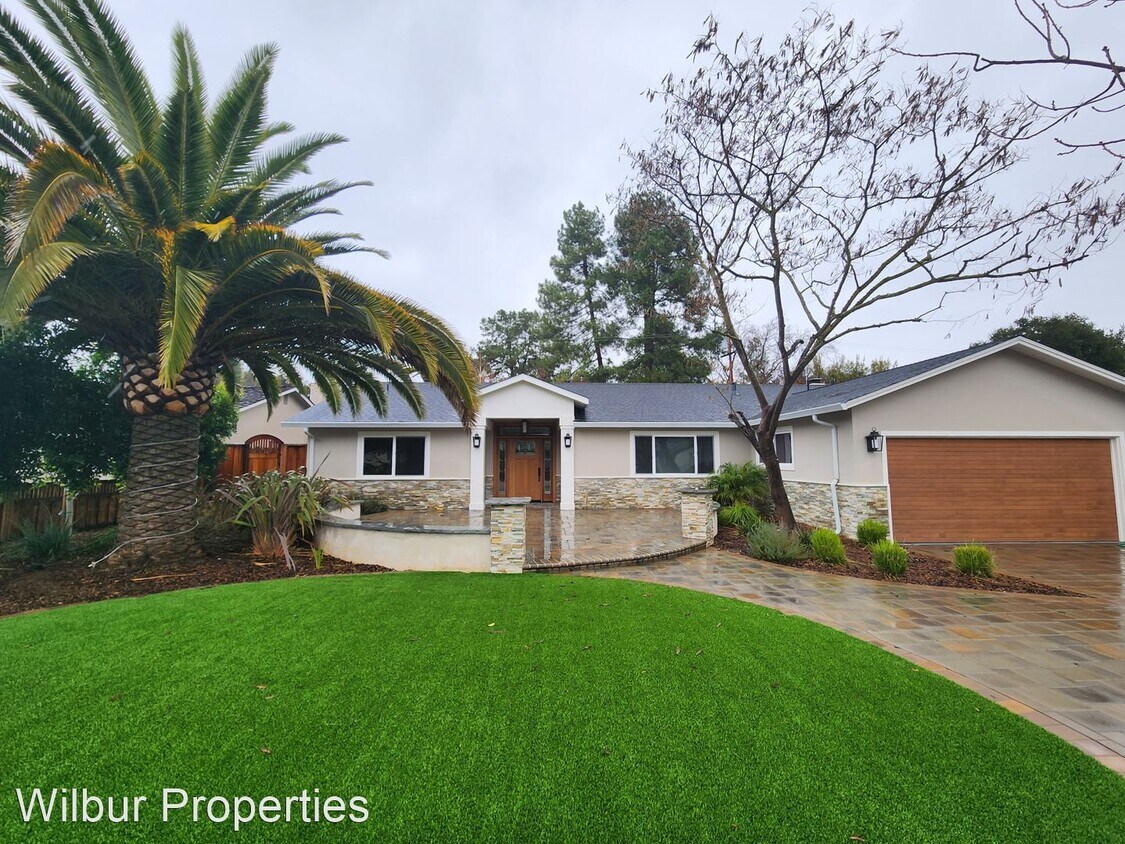
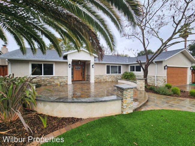
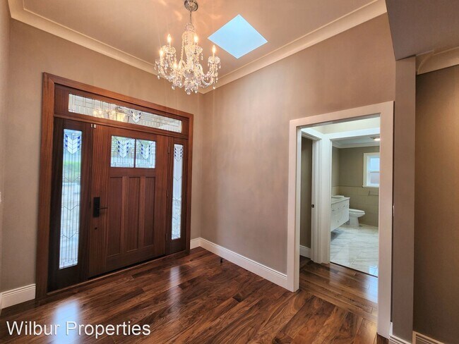
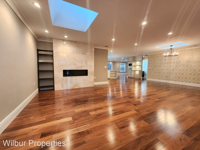
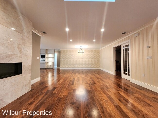
- Luxurious Single Family Home In Los Altos Available Now! - This magnificent 5 bedroom 3 bath home with 3,027 square feet of living space sits on a quiet cul-de-sac. The exquisite details include rich hardwood floors, custom lighting, crown molding, two primary suites, granite countertops, and decorative finishes. The kitchen boasts an open concept connected to the family room and dining area. It includes high end stainless steel appliances, amazing cabinetry, designer lighting, and a Carrera marble island perfect for entertaining. The irresistible landscape features multiple patio seating areas, a hot tub, a massive palm tree in the front yard, and a two car attached garage. Tenant is responsible for all utilities. Gardening included with the monthly rent. Excellent school district: Oak Avenue Elementary School Georgina P. Blach Junior High School Mountain View High School (Tenant to verify schools) This prime location is nearby parks, grocery stores, and freeway access. Minimum 12 month lease term. Applicants are subject to credit and background screening. All Wilbur Properties tenants will need to go through an application process. Each application is $50 per person over the age of 18. Please be aware of the following tenant criteria prior to setting up an appointment: 1. A credit score of greater than 700 2. Gross household income of 1.5 times or greater than the asking rent 3. Landlord reference(s) 4. Employment verification(s) This property is professionally managed by Wilbur Properties. DRE#00823559 (RLNE7865150)
1271 Petersen Ct is a house located in Santa Clara County and the 94024 ZIP Code. This area is served by the Los Altos Elementary attendance zone.
Location
Get Directions
Los Altos likes to strike a balance between the urbanized atmosphere of the Bay Area and the more rural environment of the wide-open spaces bordering the city’s southwest side. While it is mainly a residential community, the downtown area surrounding Main Street is a walkable shopping and dining district with tree-lined streets and several public parks nearby. The crime rate is quite low and the local schools are among the highest-performing in the state. Palo Alto is right next door and San Jose just a few minutes down the road, giving Los Altos residents convenient access to Silicon Valley’s greatest amenities.
Learn more about living in Los AltosBelow are rent ranges for similar nearby apartments
Education
| Colleges & Universities | Distance | ||
|---|---|---|---|
| Colleges & Universities | Distance | ||
| Drive: | 9 min | 3.9 mi | |
| Drive: | 8 min | 4.0 mi | |
| Drive: | 13 min | 6.5 mi | |
| Drive: | 17 min | 8.2 mi |
1271 Petersen Ct is within 9 minutes or 3.9 miles from Foothill Coll., Los Altos. It is also near De Anza College and Foothill College, Middlefield.
Schools


Public Elementary School
Grades K-5
367 Students
Nearby
Public Elementary School
Grades K-6
332 Students
Attendance Zone
Public Middle School
Grades 7-8
416 Students
Attendance Zone
Public High School
Grades 9-12
2,220 Students
Attendance Zone
Private Elementary & Middle School
Grades PK-8
114 Students
Nearby
Private High School
Grades 9-12
1,776 Students
Nearby
School data provided by
 The GreatSchools Rating helps parents compare schools within a state based on a variety of school quality indicators and provides a helpful picture of how effectively each school serves all of its students. Ratings are on a scale of 1 (below average) to 10 (above average) and can include test scores, college readiness, academic progress, advanced courses, equity, discipline and attendance data. We also advise parents to visit schools, consider other information on school performance and programs, and consider family needs as part of the school selection process.
View GreatSchools Rating Methodology
Data provided by GreatSchools.org © 2025. All rights reserved.
View GreatSchools Rating Methodology
Data provided by GreatSchools.org © 2025. All rights reserved.
Transportation options available in Los Altos include Mountain View Station, located 3.2 miles from 1271 Petersen Ct. 1271 Petersen Ct is near Norman Y Mineta San Jose International, located 11.3 miles or 18 minutes away, and San Francisco International, located 28.4 miles or 38 minutes away.
| Transit / Subway | Distance | ||
|---|---|---|---|
| Transit / Subway | Distance | ||
| Drive: | 8 min | 3.2 mi | |
|
|
Drive: | 8 min | 3.3 mi |
|
|
Drive: | 8 min | 3.4 mi |
|
|
Drive: | 8 min | 3.7 mi |
|
|
Drive: | 10 min | 4.6 mi |
| Commuter Rail | Distance | ||
|---|---|---|---|
| Commuter Rail | Distance | ||
| Drive: | 8 min | 3.0 mi | |
| Drive: | 8 min | 3.1 mi | |
| Drive: | 11 min | 4.8 mi | |
| Drive: | 11 min | 5.4 mi | |
| Drive: | 14 min | 6.5 mi |
| Airports | Distance | ||
|---|---|---|---|
| Airports | Distance | ||
|
Norman Y Mineta San Jose International
|
Drive: | 18 min | 11.3 mi |
|
San Francisco International
|
Drive: | 38 min | 28.4 mi |
Time and distance from 1271 Petersen Ct.
| Shopping Centers | Distance | ||
|---|---|---|---|
| Shopping Centers | Distance | ||
| Drive: | 4 min | 1.6 mi | |
| Drive: | 4 min | 1.6 mi | |
| Drive: | 5 min | 1.7 mi |
1271 Petersen Ct has 3 shopping centers within 1.7 miles, which is about a 5-minute drive. The miles and minutes will be for the farthest away property.
| Parks and Recreation | Distance | ||
|---|---|---|---|
| Parks and Recreation | Distance | ||
|
Deer Hollow Farm
|
Drive: | 8 min | 3.2 mi |
|
Rancho San Antonio County Park
|
Drive: | 9 min | 3.3 mi |
|
Redwood Grove
|
Drive: | 8 min | 3.3 mi |
|
McClellan Ranch Park
|
Drive: | 9 min | 3.6 mi |
|
Foothill College Observatory
|
Drive: | 10 min | 4.1 mi |
1271 Petersen Ct has 5 parks within 4.1 miles, including Deer Hollow Farm, Rancho San Antonio County Park, and Redwood Grove.
| Hospitals | Distance | ||
|---|---|---|---|
| Hospitals | Distance | ||
| Drive: | 3 min | 1.1 mi | |
| Drive: | 12 min | 5.8 mi | |
| Drive: | 11 min | 6.4 mi |
1271 Petersen Ct has 3 hospitals within 6.4 miles, the nearest is El Camino Hospital which is 1.1 miles away and a 3 minute drive.
| Military Bases | Distance | ||
|---|---|---|---|
| Military Bases | Distance | ||
| Drive: | 13 min | 5.4 mi |
1271 Petersen Ct is 5.4 miles and a 13 minute drive from Ames Research Center.
You May Also Like
Similar Rentals Nearby


What Are Walk Score®, Transit Score®, and Bike Score® Ratings?
Walk Score® measures the walkability of any address. Transit Score® measures access to public transit. Bike Score® measures the bikeability of any address.
What is a Sound Score Rating?
A Sound Score Rating aggregates noise caused by vehicle traffic, airplane traffic and local sources

1271 Petersen Ct
Los Altos, CA 94024