

$1,400
/ Month
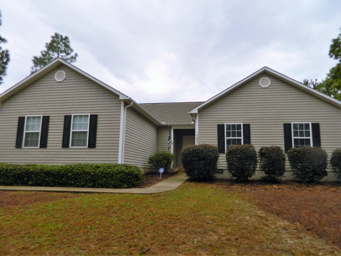
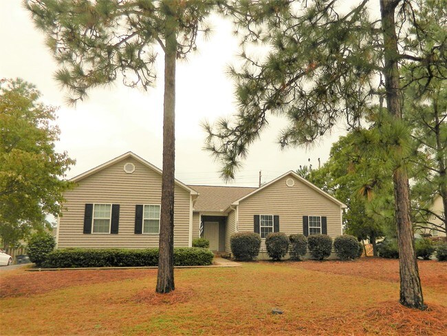
1265 Burning Tree Rd
Pinehurst, NC 28374
Favorites
1265 Burning Tree Rd

Favorites
Check Back Soon for Upcoming Availability
| Beds | Baths | Average SF |
|---|---|---|
| 3 Bedrooms 3 Bedrooms 3 Br | 2 Baths 2 Baths 2 Ba | — |
About This Property
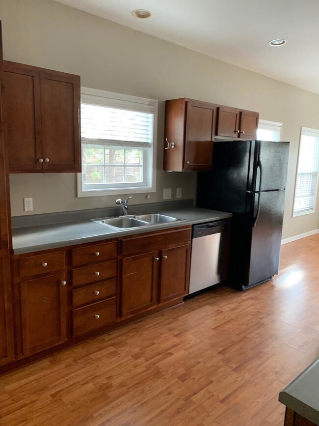
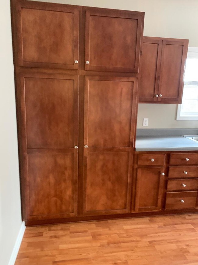
Lovely 4 bedroom single family home close to Lake Pinehurst. This home has a split bedroom plan with an open living room/ dining area and Kitchen. There is a separate laundry room between the kitchen and garage. The master bedroom is large with 2 walk in closets, double vanity in the bathroom, with a bathtub and shower. The kitchen has lots of cabinet space and 2 pantry cabinets. The lot is fully fenced. Pets upon owner approval with a non refundable pet fee. Owner to manage. Available Jan 1, possibly a few days before.
1265 Burning Tree Rd is a house located in Moore County and the 28374 ZIP Code. This area is served by the Moore County School District attendance zone.
1265 Burning Tree Rd,
Pinehurst,
NC
28374
Education
| Colleges & Universities | Distance | ||
|---|---|---|---|
| Colleges & Universities | Distance | ||
| Drive: | 19 min | 8.6 mi | |
| Drive: | 57 min | 37.4 mi | |
| Drive: | 68 min | 41.7 mi | |
| Drive: | 71 min | 44.3 mi |
1265 Burning Tree Rd is within 19 minutes or 8.6 miles from Sandhills Community College. It is also near Central Carolina Comm. Coll. and Fayetteville Tech. Comm. Coll..
Schools


Public Elementary School
Grades PK-5
322 Students
Nearby
Public Elementary School
Grades K-5
624 Students
Attendance Zone
Public Middle School
Grades 6-8
688 Students
Attendance Zone
Public High School
Grades 9-12
2,221 Students
Attendance Zone
Private Elementary, Middle & High School
Grades PK-12
139 Students
Nearby
Private Elementary, Middle & High School
Grades PK-12
49 Students
Nearby
School data provided by
 The GreatSchools Rating helps parents compare schools within a state based on a variety of school quality indicators and provides a helpful picture of how effectively each school serves all of its students. Ratings are on a scale of 1 (below average) to 10 (above average) and can include test scores, college readiness, academic progress, advanced courses, equity, discipline and attendance data. We also advise parents to visit schools, consider other information on school performance and programs, and consider family needs as part of the school selection process.
View GreatSchools Rating Methodology
Data provided by GreatSchools.org © 2026. All rights reserved.
View GreatSchools Rating Methodology
Data provided by GreatSchools.org © 2026. All rights reserved.
Walkability Near 1265 Burning Tree Rd Pinehurst, NC 28374
Getting Around
 What do Walkability, Transit, Drivability, and Bikeability mean?
Walkability measures the walking distance to day-to-day needs.
Transit measures access to public transportation.
Drivability measures congestion, parking availability, and access to major roads.
Bikeability measures the suitability for cycling.
How It Works
What do Walkability, Transit, Drivability, and Bikeability mean?
Walkability measures the walking distance to day-to-day needs.
Transit measures access to public transportation.
Drivability measures congestion, parking availability, and access to major roads.
Bikeability measures the suitability for cycling.
How It Works
Somewhat Walkable
Walkability
20
/ 100
Exceptionally Drivable
Drivability
100
/ 100
Somewhat Bikeable
Bikeability
20
/ 100
Scores provided by
-
Soundscore™
-
/ 100
Traffic
-Airport
-Businesses
-Scores provided by
HowLoud What is a Sound Score Rating? A Sound Score Rating aggregates noise caused by vehicle traffic, airplane traffic and local sources. How It WorksYou May Also Like
Similar Rentals Nearby
-
-

-

-

-
 3 Beds, 2 Baths, 2,037 sq ft$2,100Total Monthly Price12 Month LeaseTotal Monthly Price NewPrices include all required monthly fees.100 Bridle Path Cir
 -
 3 Beds, 2 Baths, 1,524 sq ft$2,400Total Monthly Price12 Month LeaseTotal Monthly Price NewPrices include all required monthly fees.2400 Longleaf Dr SW
 -
 3 Beds, 2 Baths, 1,600 sq ft$2,100Total Monthly Price12 Month LeaseTotal Monthly Price NewPrices include all required monthly fees.9 Remington Ln
 -
 3 Beds, 2 Baths, 1,510 sq ft$1,900Total Monthly PriceTotal Monthly Price NewPrices include all required monthly fees.85 Sawmill Rd W
 -
 3 Beds, 3 Baths, 1,850 sq ft$2,150Total Monthly Price12 Month LeaseTotal Monthly Price NewPrices include all required monthly fees.203 S Pine St
 -
 3 Beds, 2 Baths, 1,400 sq ft$1,600Total Monthly Price12 Month LeaseTotal Monthly Price NewPrices include all required monthly fees.902 Heather Trail
What Are Walk Score®, Transit Score®, and Bike Score® Ratings?
Walk Score® measures the walkability of any address. Transit Score® measures access to public transit. Bike Score® measures the bikeability of any address.
What is a Sound Score Rating?
A Sound Score Rating aggregates noise caused by vehicle traffic, airplane traffic and local sources.

1265 Burning Tree Rd
Pinehurst, NC 28374