
$1,500
/ Month
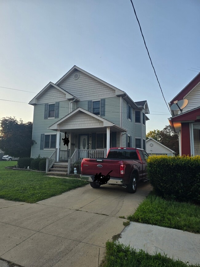
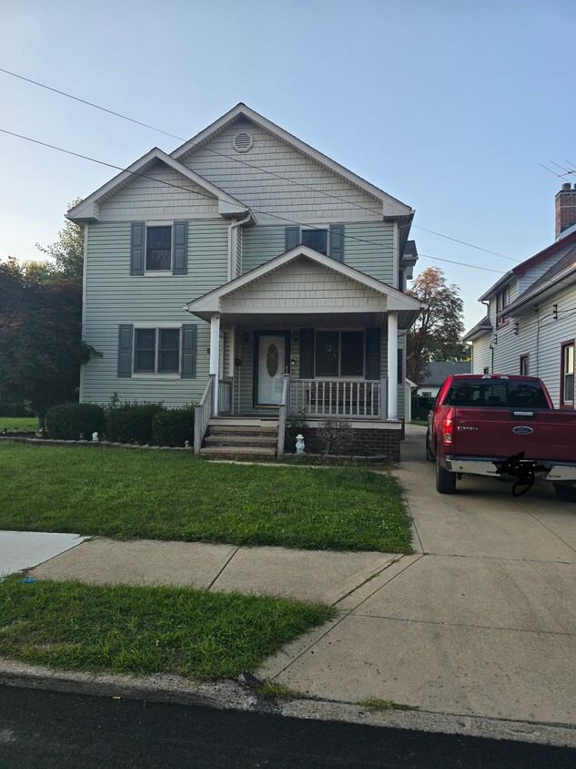
12602 Bennington Ave
Cleveland, OH 44135
Today
Favorites
216-369-6711
-
Bedrooms
4
-
Bathrooms
2.5
-
Square Feet
1,600 sq ft
-
Available
Available Oct 1
Highlights
- Basement
- Playground
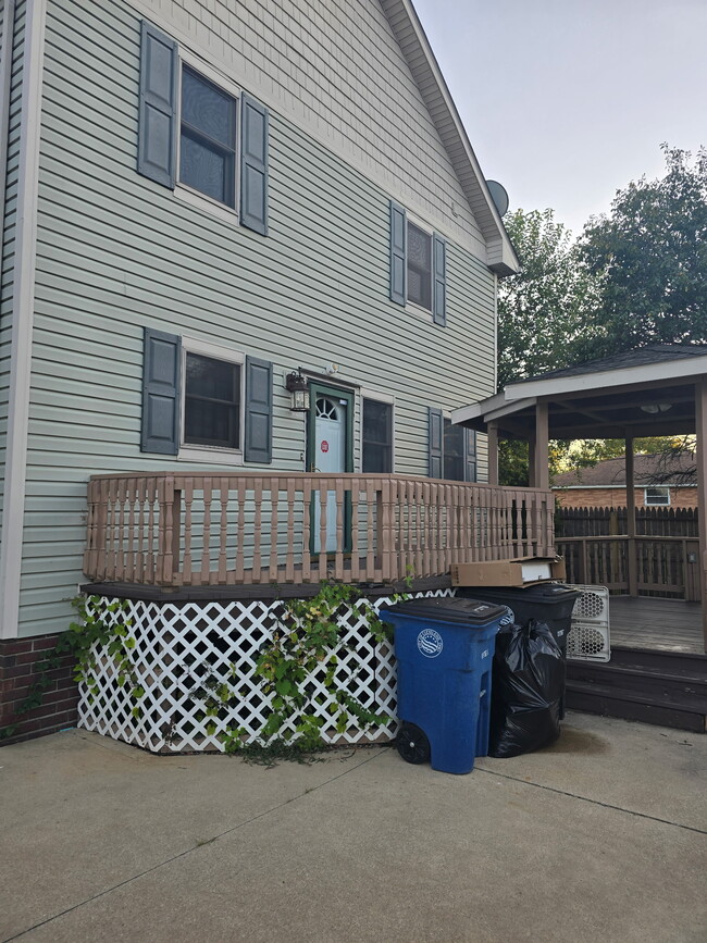
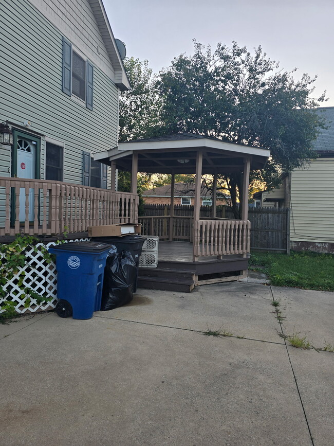
- Deck
- Double Vanities
12602 Bennington Ave

Favorites
About This Home
12 Month Lease,
$1,500 deposit,
Available Oct 1
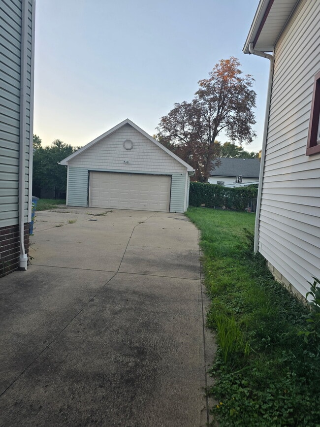
Four bedrooms, two and a half baths, dining room, office, and upstairs common area. Two car garage, full basement. Close to playgrounds. Close to shopping centers, gas stations, highways, and public transportation. 15 minutes to downtown. Deck with gazebo. Ceiling fans and central air conditioning.
12602 Bennington Ave is a house located in Cuyahoga County and the 44135 ZIP Code.
* Price shown is base rent. Excludes user-selected optional fees and variable or usage-based fees and required charges due at or prior to move-in or at move-out. Price, availability, fees, and any applicable rent special are subject to change without notice.
* Square footage definitions vary. Displayed square footage is approximate.
House Features
Air Conditioning
Washer/Dryer Hookup
Tub/Shower
Office
- Washer/Dryer Hookup
- Air Conditioning
- Heating
- Ceiling Fans
- Cable Ready
- Storage Space
- Double Vanities
- Tub/Shower
- Dining Room
- Basement
- Office
- Playground
- Deck
Fees and Policies
The fees below are based on community-supplied data and may exclude additional fees and utilities.
- Parking
-
Garage--
Contact
- Phone Number
Location
Get Directions
With fewer than 20 minutes separating Puritas-Longmead from Cleveland, the neighborhood’s ideal location ensures residents plenty of options in shopping, dining, entertainment, and cultural happenings. Residents can easily enjoy the busy urban lifestyle, living just southwest of the city, while still being able to enjoy a peaceful suburban community when returning back home. Spread out amongst Puritas-Longmead's mix of industrial and residential areas, green spaces create a vibrant environment and plenty of space to unwind. Affordable rentals make Puritas-Longmead a fantastic choice for renters who want to be near the city but don’t want to pay big city bucks.
Learn more about living in Puritas-Longmead
Education
| Colleges & Universities | Distance | ||
|---|---|---|---|
| Colleges & Universities | Distance | ||
| Drive: | 13 min | 5.3 mi | |
| Drive: | 13 min | 7.3 mi | |
| Drive: | 16 min | 9.1 mi | |
| Drive: | 15 min | 9.9 mi |
12602 Bennington Ave is within 13 minutes or 5.3 miles from Cuyahoga C.C., Western Campus. It is also near Baldwin - Wallace College and Cuyahoga C.C., Metropolitan.
Transportation options available in Cleveland include Brookpark Station, located 3.0 miles from 12602 Bennington Ave. 12602 Bennington Ave is near Cleveland-Hopkins International, located 5.0 miles or 11 minutes away.
| Transit / Subway | Distance | ||
|---|---|---|---|
| Transit / Subway | Distance | ||
| Drive: | 6 min | 3.0 mi | |
|
|
Drive: | 6 min | 3.1 mi |
| Drive: | 9 min | 3.5 mi | |
|
|
Drive: | 9 min | 3.5 mi |
|
|
Drive: | 10 min | 3.5 mi |
| Commuter Rail | Distance | ||
|---|---|---|---|
| Commuter Rail | Distance | ||
| Drive: | 18 min | 10.7 mi | |
|
|
Drive: | 22 min | 11.3 mi |
| Drive: | 20 min | 12.2 mi | |
| Drive: | 28 min | 17.5 mi | |
|
Boston Mill
|
Drive: | 36 min | 22.6 mi |
| Airports | Distance | ||
|---|---|---|---|
| Airports | Distance | ||
|
Cleveland-Hopkins International
|
Drive: | 11 min | 5.0 mi |
Time and distance from 12602 Bennington Ave.
| Shopping Centers | Distance | ||
|---|---|---|---|
| Shopping Centers | Distance | ||
| Drive: | 4 min | 1.5 mi | |
| Drive: | 6 min | 2.1 mi | |
| Drive: | 4 min | 2.1 mi |
12602 Bennington Ave has 3 shopping centers within 2.1 miles, which is about a 4-minute drive. The miles and minutes will be for the farthest away property.
| Parks and Recreation | Distance | ||
|---|---|---|---|
| Parks and Recreation | Distance | ||
|
Big Creek Reservation
|
Drive: | 6 min | 2.7 mi |
|
Cleveland Metroparks Zoo
|
Drive: | 10 min | 5.7 mi |
|
Lakefront Reservation and Edgewater Park
|
Drive: | 16 min | 6.6 mi |
|
Rocky River Nature Center
|
Drive: | 12 min | 7.0 mi |
|
West Creek Reservation
|
Drive: | 18 min | 8.1 mi |
12602 Bennington Ave has 5 parks within 8.1 miles, including Big Creek Reservation, Cleveland Metroparks Zoo, and Lakefront Reservation and Edgewater Park.
| Hospitals | Distance | ||
|---|---|---|---|
| Hospitals | Distance | ||
| Drive: | 10 min | 4.9 mi | |
| Drive: | 12 min | 5.5 mi | |
| Drive: | 11 min | 6.5 mi |
12602 Bennington Ave has 3 hospitals within 6.5 miles, the nearest is Fairview Hospital which is 4.9 miles away and a 10 minute drive.
| Military Bases | Distance | ||
|---|---|---|---|
| Military Bases | Distance | ||
| Drive: | 88 min | 73.9 mi | |
| Drive: | 93 min | 77.0 mi |
12602 Bennington Ave is 73.9 miles from Mansfield Lahm Airport Air Guard Station, and is convenient to other military bases, including Camp Perry Air Guard Station.
Amenities
- Washer/Dryer Hookup
- Air Conditioning
- Heating
- Ceiling Fans
- Cable Ready
- Storage Space
- Double Vanities
- Tub/Shower
- Dining Room
- Basement
- Office
- Deck
- Playground
12602 Bennington Ave Photos
What Are Walk Score®, Transit Score®, and Bike Score® Ratings?
Walk Score® measures the walkability of any address. Transit Score® measures access to public transit. Bike Score® measures the bikeability of any address.
What is a Sound Score Rating?
A Sound Score Rating aggregates noise caused by vehicle traffic, airplane traffic and local sources
12602 Bennington Ave
Cleveland, OH 44135