

$2,880 / Month
1255 N Los Robles Ave Unit 31
Pasadena, CA 91104
2 Weeks Ago
Favorites
1255 N Los Robles Ave Unit 31

Favorites
Check Back Soon for Upcoming Availability
| Beds | Baths | Average SF |
|---|---|---|
| 3 Bedrooms 3 Bedrooms 3 Br | 2 Baths 2 Baths 2 Ba | 1,040 SF |
About This Property
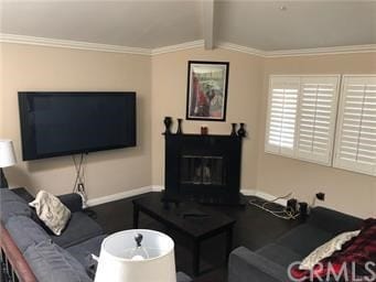
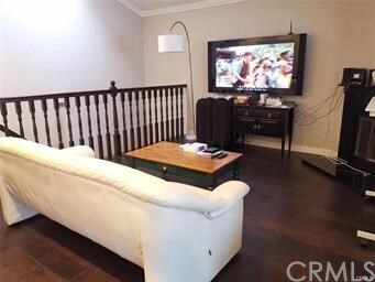
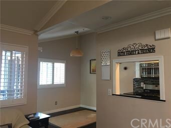
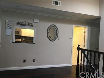
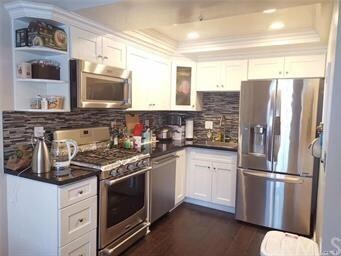
Gated Community in Quiet Area. Rent includes Water/Trash/HOA Due/Refrigerator/Dryer/Washer/Large TV. Totally Remodeled, 2 Car Garage Can Direct Access Inside the House, Master Bedroom in Downstairs Has Sliding Door To Patio Area, Two Bedrooms Upstairs With New Bathroom, Vaulted Ceilings in Family w/Fireplace. Kitchen With Quartz Counter Tops, New Cabinets And Stainless Steel Appliances, Eating Area Off Balcony, Hardwood Floors Throughout, New Paint, New Led Lights, New windows, New Wood Shutters. 220 Volt in garage for E-charging. First Month Rent + Security Deposit to Move In. Easy to Show, See Remarks Please.
1255 N Los Robles Ave is a condo located in Los Angeles County and the 91104 ZIP Code. This area is served by the Pasadena Unified attendance zone.
Condo Features
- Fireplace
Location
Get Directions
Near the San Gabriel Mountains, where I-210 meets State Route 134 and becomes the Foothill Freeway, rests Pasadena’s Garfield Heights neighborhood. Primarily a residential area, Garfield Heights contains a number of markets, churches, and temples. Garfield Heights residents enjoy access to neighboring parks such as La Pintoresca Park and City of Pasadena Robinson Park.
There are a host of amenities located within close proximity to Garfield Heights. Among the many amenities are the Rose Bowl Stadium, Kidspace Children’s Museum, Norton Simon Museum, Brookside Golf and Country Club, Pasadena Convention Center, Paseo Colorado, and the California Institute of Technology.
Served by several Metro Local lines and Pasadena Transit routes, getting around Garfield Height is a breeze.
Learn more about living in Garfield HeightsBelow are rent ranges for similar nearby apartments
Amenities
- Fireplace
Education
| Colleges & Universities | Distance | ||
|---|---|---|---|
| Colleges & Universities | Distance | ||
| Drive: | 3 min | 1.5 mi | |
| Drive: | 6 min | 2.9 mi | |
| Drive: | 7 min | 3.2 mi | |
| Drive: | 10 min | 3.5 mi |
1255 N Los Robles Ave Unit 31 is within 3 minutes or 1.5 miles from Fuller Theological Seminary. It is also near Pasadena City College and Caltech.
Schools


Public Elementary School
Grades K-6
454 Students
Nearby
Public Elementary School
Grades K-5
406 Students
Attendance Zone
Public Middle School
Grades 6-8
513 Students
Attendance Zone
Public High School
Grades 9-12
1,012 Students
Attendance Zone
Private Elementary & Middle School
Grades 2-9
Nearby
Private Elementary & Middle School
Grades PK-8
444 Students
Nearby
Private Middle & High School
Grades 7-12
18 Students
Nearby
School data provided by
 The GreatSchools Rating helps parents compare schools within a state based on a variety of school quality indicators and provides a helpful picture of how effectively each school serves all of its students. Ratings are on a scale of 1 (below average) to 10 (above average) and can include test scores, college readiness, academic progress, advanced courses, equity, discipline and attendance data. We also advise parents to visit schools, consider other information on school performance and programs, and consider family needs as part of the school selection process.
View GreatSchools Rating Methodology
Data provided by GreatSchools.org © 2025. All rights reserved.
View GreatSchools Rating Methodology
Data provided by GreatSchools.org © 2025. All rights reserved.
Transportation options available in Pasadena include Memorial Park Station, located 1.8 miles from 1255 N Los Robles Ave Unit 31. 1255 N Los Robles Ave Unit 31 is near Bob Hope, located 17.8 miles or 24 minutes away, and Los Angeles International, located 26.6 miles or 42 minutes away.
| Transit / Subway | Distance | ||
|---|---|---|---|
| Transit / Subway | Distance | ||
|
|
Drive: | 4 min | 1.8 mi |
|
|
Drive: | 5 min | 2.2 mi |
|
|
Drive: | 4 min | 2.2 mi |
|
|
Drive: | 5 min | 2.7 mi |
|
|
Drive: | 6 min | 3.0 mi |
| Commuter Rail | Distance | ||
|---|---|---|---|
| Commuter Rail | Distance | ||
|
|
Drive: | 14 min | 10.3 mi |
|
|
Drive: | 19 min | 11.5 mi |
|
|
Drive: | 21 min | 11.6 mi |
|
|
Drive: | 21 min | 11.7 mi |
| Drive: | 23 min | 15.6 mi |
| Airports | Distance | ||
|---|---|---|---|
| Airports | Distance | ||
|
Bob Hope
|
Drive: | 24 min | 17.8 mi |
|
Los Angeles International
|
Drive: | 42 min | 26.6 mi |
Time and distance from 1255 N Los Robles Ave Unit 31.
| Shopping Centers | Distance | ||
|---|---|---|---|
| Shopping Centers | Distance | ||
| Walk: | 8 min | 0.4 mi | |
| Walk: | 12 min | 0.6 mi | |
| Walk: | 13 min | 0.7 mi |
1255 N Los Robles Ave Unit 31 has 3 shopping centers within 0.7 mile, which is about a 13-minute walk. The miles and minutes will be for the farthest away property.
| Parks and Recreation | Distance | ||
|---|---|---|---|
| Parks and Recreation | Distance | ||
|
Kidspace Children's Museum
|
Drive: | 6 min | 2.5 mi |
|
Jet Propulsion Laboratory
|
Drive: | 5 min | 2.7 mi |
|
Eaton Canyon Nature Center
|
Drive: | 7 min | 3.3 mi |
|
Huntington Botanical Gardens
|
Drive: | 10 min | 4.3 mi |
|
Descanso Gardens
|
Drive: | 11 min | 6.1 mi |
1255 N Los Robles Ave Unit 31 has 5 parks within 6.1 miles, including Kidspace Children's Museum, Jet Propulsion Laboratory, and Eaton Canyon Nature Center.
| Hospitals | Distance | ||
|---|---|---|---|
| Hospitals | Distance | ||
| Drive: | 5 min | 2.8 mi | |
| Drive: | 8 min | 4.7 mi | |
| Drive: | 10 min | 6.0 mi |
1255 N Los Robles Ave Unit 31 has 3 hospitals within 6.0 miles, the nearest is Huntington Memorial Hospital which is 2.8 miles away and a 5 minute drive.
| Military Bases | Distance | ||
|---|---|---|---|
| Military Bases | Distance | ||
| Drive: | 39 min | 28.1 mi | |
| Drive: | 49 min | 31.4 mi |
1255 N Los Robles Ave Unit 31 is 28.1 miles from Los Angeles Air Force Base, and is convenient to other military bases, including Los Alamitos Army Airfield.
You May Also Like
Similar Rentals Nearby


What Are Walk Score®, Transit Score®, and Bike Score® Ratings?
Walk Score® measures the walkability of any address. Transit Score® measures access to public transit. Bike Score® measures the bikeability of any address.
What is a Sound Score Rating?
A Sound Score Rating aggregates noise caused by vehicle traffic, airplane traffic and local sources
1255 N Los Robles Ave
Pasadena, CA 91104