

$2,200
/ Month
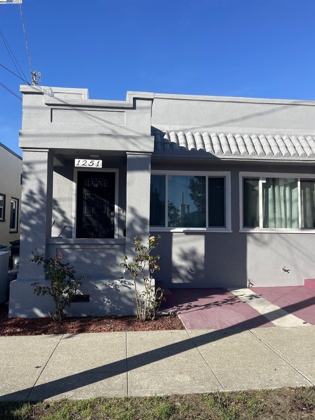
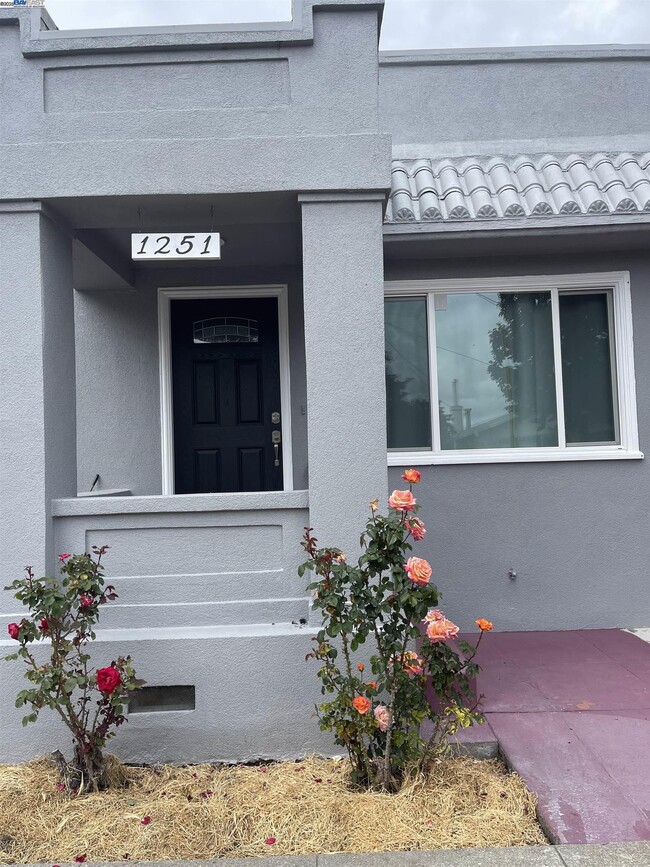
1251 Burnett St
Berkeley, CA 94702
Today
|
Edit
Favorites
510-703-2886
-
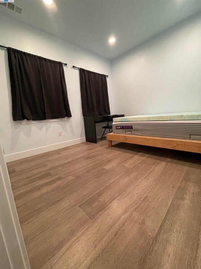
Bedrooms
1
-
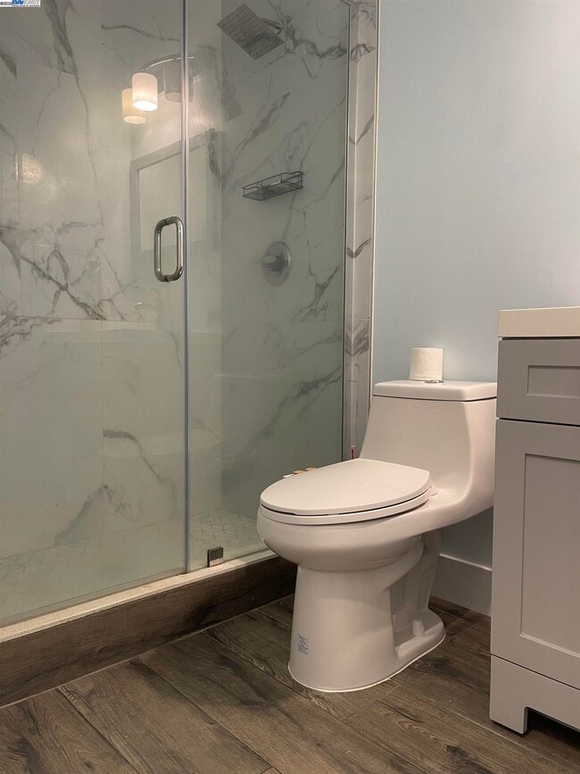
Bathrooms
1
-
Square Feet
520 sq ft
-
Available
Available Now
Highlights
- Wood Flooring
- Cottage
- Cooling Available
- Tile Flooring
- Concrete Flooring
- Heat Pump System
1251 Burnett St

Favorites
About This Home
Available Now
New remodel with all hardwood floors update kitchen and all the band new appliance. Property locate in a nice neighborhoods and very convenient location close to public transportation park and shopping . Apply with RentSpree
1251 Burnett St is a townhome located in Alameda County and the 94702 ZIP Code. This area is served by the Berkeley Unified attendance zone.
* Price shown is base rent. Excludes user-selected optional fees and variable or usage-based fees and required charges due at or prior to move-in or at move-out. Price, availability, fees, and any applicable rent special are subject to change without notice.
* Square footage definitions vary. Displayed square footage is approximate.
Home Details
Home Type
Duplex
Year Built
Built in 1922
Bedrooms and Bathrooms
1 Full Bathroom
1 Bedroom
Flooring
Wood
Tile
Concrete
Home Design
Cottage
Bungalow
Rolled or Hot Mop Roof
Stucco
Interior Spaces
1-Story Property
Kitchen
Free-Standing Range
Dishwasher
Laundry
Washer and Dryer Hookup
Listing and Financial Details
Assessor Parcel Number 5316295
Lot Details
3,128 Sq Ft Lot
Back Yard
Parking
Off-Street Parking
Utilities
Cooling Available
Gas Water Heater
Heat Pump System
Community Details
Overview
No Home Owners Association
Berkeley Subdivision
Contact
- Listed by Heng Chieng | Intero Real Estate Services
- Phone Number
- Contact
-
Source
 Bay East Association of REALTORS ®
Copyright© 2026 Bay East, Contra Costa, bridgeMLS. All rights reserved. All information provided by the listing agent/broker is deemed reliable but is not guaranteed and should be independently verified.
Location
Get Directions
Southwest Berkeley is bounded by University Avenue to the north, Sacramento Street to the East, Alcatraz Avenue to the south and the San Francisco Bay to the west. Southwest Berkeley comprises a fascinating mix of the educational and the industrial. Less dense than the more inland parts of Berkeley, Southwest Berkeley has a diverse mix of apartment and home rentals that will delight students and families alike. Convenient access to the illustrious university make this a great option for students and staff, but any renter will love the restaurant and retail options that make this walkable locale so convenient.
Learn more about living in Southwest Berkeley
Education
| Colleges & Universities | Distance | ||
|---|---|---|---|
| Colleges & Universities | Distance | ||
| Drive: | 6 min | 2.1 mi | |
| Drive: | 8 min | 3.2 mi | |
| Drive: | 10 min | 3.4 mi | |
| Drive: | 10 min | 4.1 mi |
1251 Burnett St is within 6 minutes or 2.1 miles from Berkeley City College. It is also near Samuel Merritt University and UC Berkeley.
Schools


Public Elementary School
Grades K-5
459 Students
Attendance Zone
Public Elementary School
Grades K-5
395 Students
Attendance Zone
Public Elementary School
Grades K-5
270 Students
Nearby
Public Middle School
Grades 6-8
871 Students
Attendance Zone
Public High School
Grades 9-12
3,204 Students
Attendance Zone
Private Elementary & Middle School
Grades PK-8
440 Students
Nearby
Private Elementary School
Grades K
20 Students
Nearby
School data provided by
 The GreatSchools Rating helps parents compare schools within a state based on a variety of school quality indicators and provides a helpful picture of how effectively each school serves all of its students. Ratings are on a scale of 1 (below average) to 10 (above average) and can include test scores, college readiness, academic progress, advanced courses, equity, discipline and attendance data. We also advise parents to visit schools, consider other information on school performance and programs, and consider family needs as part of the school selection process.
View GreatSchools Rating Methodology
Data provided by GreatSchools.org © 2026. All rights reserved.
View GreatSchools Rating Methodology
Data provided by GreatSchools.org © 2026. All rights reserved.
Transportation options available in Berkeley include Ashby Station, located 1.0 mile from 1251 Burnett St. 1251 Burnett St is near Metro Oakland International, located 13.7 miles or 23 minutes away, and San Francisco International, located 22.7 miles or 36 minutes away.
| Transit / Subway | Distance | ||
|---|---|---|---|
| Transit / Subway | Distance | ||
|
|
Walk: | 19 min | 1.0 mi |
|
|
Drive: | 5 min | 1.9 mi |
|
|
Drive: | 6 min | 2.0 mi |
|
|
Drive: | 6 min | 2.2 mi |
|
|
Drive: | 6 min | 2.2 mi |
| Commuter Rail | Distance | ||
|---|---|---|---|
| Commuter Rail | Distance | ||
|
|
Drive: | 4 min | 1.4 mi |
|
|
Drive: | 5 min | 2.0 mi |
|
|
Drive: | 11 min | 4.9 mi |
| Drive: | 14 min | 8.5 mi | |
| Drive: | 17 min | 10.2 mi |
| Airports | Distance | ||
|---|---|---|---|
| Airports | Distance | ||
|
Metro Oakland International
|
Drive: | 23 min | 13.7 mi |
|
San Francisco International
|
Drive: | 36 min | 22.7 mi |
Time and distance from 1251 Burnett St.
| Shopping Centers | Distance | ||
|---|---|---|---|
| Shopping Centers | Distance | ||
| Drive: | 5 min | 1.6 mi | |
| Drive: | 5 min | 1.7 mi | |
| Drive: | 5 min | 1.7 mi |
1251 Burnett St has 3 shopping centers within 1.7 miles, which is about a 5-minute drive. The miles and minutes will be for the farthest away property.
| Parks and Recreation | Distance | ||
|---|---|---|---|
| Parks and Recreation | Distance | ||
|
San Francisco Bay Trail (at Emeryville)
|
Drive: | 3 min | 1.2 mi |
|
Strawberry Creek Park
|
Drive: | 4 min | 1.5 mi |
|
Willard Park
|
Drive: | 6 min | 1.9 mi |
|
Habitot Children's Museum
|
Drive: | 6 min | 2.0 mi |
|
Cedar-Rose Park
|
Drive: | 6 min | 2.3 mi |
1251 Burnett St has 5 parks within 2.3 miles, including Strawberry Creek Park, San Francisco Bay Trail (at Emeryville), and Willard Park.
| Hospitals | Distance | ||
|---|---|---|---|
| Hospitals | Distance | ||
| Drive: | 5 min | 1.6 mi | |
| Drive: | 5 min | 1.8 mi | |
| Drive: | 8 min | 3.2 mi |
1251 Burnett St has 3 hospitals within 3.2 miles, the nearest is Alta Bates Summit Medical Center - Alta Bates Campus which is 1.6 miles away and a 5 minute drive.
| Military Bases | Distance | ||
|---|---|---|---|
| Military Bases | Distance | ||
| Drive: | 14 min | 5.7 mi | |
| Drive: | 15 min | 7.5 mi |
1251 Burnett St is 5.7 miles from Oakland Army Base, and is convenient to other military bases, including Military Reservation.
You May Also Like
Similar Rentals Nearby


What Are Walk Score®, Transit Score®, and Bike Score® Ratings?
Walk Score® measures the walkability of any address. Transit Score® measures access to public transit. Bike Score® measures the bikeability of any address.
What is a Sound Score Rating?
A Sound Score Rating aggregates noise caused by vehicle traffic, airplane traffic and local sources

1251 Burnett St
Berkeley, CA 94702