

$4,500 / Month
1246 Melanie Way
Livermore, CA 94550
2 Weeks Ago
Favorites
-
Bedrooms
4
-
Bathrooms
3
-
Square Feet
2,268 sq ft
1246 Melanie Way

Favorites
About This Home
$4,500 deposit
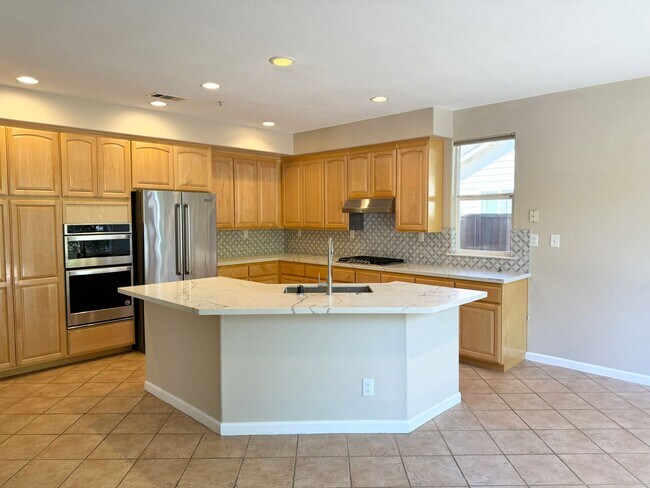
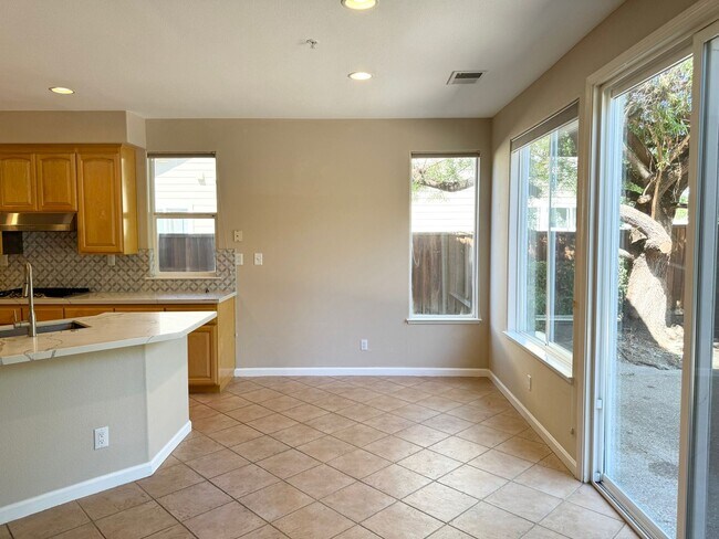
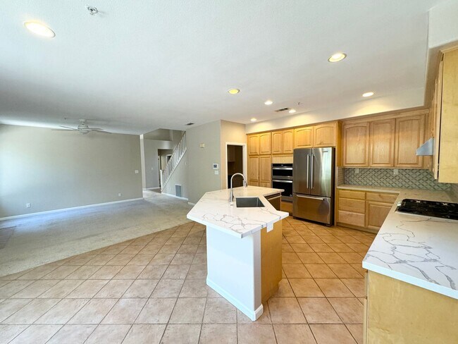
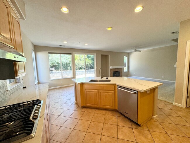
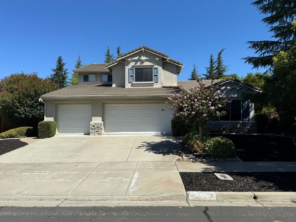
This inviting home is a true gem. It boasts fresh paint and new carpet, while the master bath features elegant tile flooring. The two bathrooms upstairs include a convenient Jack-and-Jill setup and a bedroom and bathroom on the ground floor. Enjoy the comfort of dual-zone heating and air, a brand-new water heater, stylish Hunter Douglas blinds, and a charming fireplace in the family room. The house is near the ACE train stop and conveniently close to schools, shops, and parks. The refrigerator is included, and the property features an extra-large lot. This home is perfect for entertaining with an open floor plan, spacious family and living rooms, and a large front and back yard with water-resistant landscaping for easy maintenance. Additionally, the sizable three-car garage provides ample storage space. Set in a fantastic neighborhood with easy access to Highway 580, this residence offers a beautiful place to call home. Reach out to Robert to schedule a tour! Property Requirements 650 Plus Credit Score Total income to be at least 3 times the monthly rent I understand and agree that by applying to lease with this company, I will have to create either a pet/animal profile or a no-pet profile using our firm’s third-party screening service. Robert Ventura Best Property Management CA BRE 01374185
1246 Melanie Way is a house located in Alameda County and the 94550 ZIP Code. This area is served by the Livermore Valley Joint Unified attendance zone.
* Price shown is base rent and may not include non-optional fees and utilities.
Price, availability, fees, and any applicable rent special are subject to change without notice.
* Square footage definitions vary. Displayed square footage is approximate.
Location
Get Directions
The cities of Livermore, Dublin and Pleasanton form a loosely shaped triangle within California's Tri-Valley region, a cluster of three small valleys about 33 miles east of San Francisco and 35 miles northeast of San Jose. Known for its Mediterranean climate, rolling hills and historic vineyards, this once bucolic region now boasts three separate downtown areas, a bustling business community and some of the best wineries in the state.
At the eastern end of the region lies the city of Livermore. Once known as Livermores, Livermore Ranch and Nottingham, the city sits at the center of Livermore Valley, a historic region dotted with more than 5,000 acres of mostly family-owned vineyards. A pastoral neighborhood known for its charming yet functional hilltop windmills, Livermore hosts the internationally recognized and sometimes controversial center of scientific research, Lawrence Livermore National Laboratories.
Learn more about living in Dublin/Pleasanton/Livermore
Education
| Colleges & Universities | Distance | ||
|---|---|---|---|
| Colleges & Universities | Distance | ||
| Drive: | 12 min | 7.3 mi | |
| Drive: | 17 min | 12.2 mi | |
| Drive: | 23 min | 15.9 mi | |
| Drive: | 32 min | 19.4 mi |
1246 Melanie Way is within 12 minutes or 7.3 miles from Las Positas College. It is also near San Joaquin Delta, Mtn. House and Diablo Valley Coll, San Ramon.
Schools


Public Elementary School
Grades K-5
478 Students
Nearby
Public Elementary School
Grades K-5
587 Students
Attendance Zone
Public Middle School
Grades 6-8
547 Students
Attendance Zone
Public High School
Grades 9-12
1,765 Students
Attendance Zone
Private Elementary School
Grades PK-3
64 Students
Nearby
Private Elementary, Middle & High School
Grades K-12
Nearby
School data provided by
 The GreatSchools Rating helps parents compare schools within a state based on a variety of school quality indicators and provides a helpful picture of how effectively each school serves all of its students. Ratings are on a scale of 1 (below average) to 10 (above average) and can include test scores, college readiness, academic progress, advanced courses, equity, discipline and attendance data. We also advise parents to visit schools, consider other information on school performance and programs, and consider family needs as part of the school selection process.
View GreatSchools Rating Methodology
Data provided by GreatSchools.org © 2025. All rights reserved.
View GreatSchools Rating Methodology
Data provided by GreatSchools.org © 2025. All rights reserved.
Transportation options available in Livermore include Dublin Pleasanton Station, located 12.7 miles from 1246 Melanie Way. 1246 Melanie Way is near Metro Oakland International, located 31.5 miles or 39 minutes away, and Norman Y Mineta San Jose International, located 34.3 miles or 49 minutes away.
| Transit / Subway | Distance | ||
|---|---|---|---|
| Transit / Subway | Distance | ||
|
|
Drive: | 16 min | 12.7 mi |
| Commuter Rail | Distance | ||
|---|---|---|---|
| Commuter Rail | Distance | ||
| Walk: | 17 min | 0.9 mi | |
| Drive: | 7 min | 3.6 mi | |
| Drive: | 8 min | 3.9 mi | |
| Drive: | 20 min | 10.6 mi | |
| Drive: | 20 min | 10.7 mi |
| Airports | Distance | ||
|---|---|---|---|
| Airports | Distance | ||
|
Metro Oakland International
|
Drive: | 39 min | 31.5 mi |
|
Norman Y Mineta San Jose International
|
Drive: | 49 min | 34.3 mi |
Time and distance from 1246 Melanie Way.
| Shopping Centers | Distance | ||
|---|---|---|---|
| Shopping Centers | Distance | ||
| Drive: | 2 min | 1.2 mi | |
| Drive: | 3 min | 1.8 mi | |
| Drive: | 4 min | 2.4 mi |
1246 Melanie Way has 3 shopping centers within 2.4 miles, which is about a 4-minute drive. The miles and minutes will be for the farthest away property.
| Parks and Recreation | Distance | ||
|---|---|---|---|
| Parks and Recreation | Distance | ||
|
Brushy Peak Regional Preserve
|
Drive: | 10 min | 4.8 mi |
|
Los Vaqueros Watershed
|
Drive: | 11 min | 6.3 mi |
|
Shadow Cliffs Regional Recreation Area
|
Drive: | 16 min | 8.3 mi |
|
Del Valle Regional Park
|
Drive: | 24 min | 8.5 mi |
|
Carnegie State Vehicle Recreation Area
|
Drive: | 18 min | 10.2 mi |
1246 Melanie Way has 5 parks within 10.2 miles, including Brushy Peak Regional Preserve, Los Vaqueros Watershed, and Shadow Cliffs Regional Recreation Area.
| Hospitals | Distance | ||
|---|---|---|---|
| Hospitals | Distance | ||
| Drive: | 15 min | 10.9 mi |
1246 Melanie Way is 10.9 miles and a 15 minute drive from Stanford Health Care - ValleyCare.
You May Also Like
Similar Rentals Nearby


What Are Walk Score®, Transit Score®, and Bike Score® Ratings?
Walk Score® measures the walkability of any address. Transit Score® measures access to public transit. Bike Score® measures the bikeability of any address.
What is a Sound Score Rating?
A Sound Score Rating aggregates noise caused by vehicle traffic, airplane traffic and local sources
1246 Melanie Way
Livermore, CA 94550